Miami’s Mixed Weather Bag: Sun, Clouds, and Occasional Showers!
By
Amy Freeze
This week in Miami and the Southeast, temperatures fluctuate, and unexpected showers may catch you off guard! Be ready for what’s coming with our comprehensive forecast.
Stay updated with this week’s Miami and Southeast weather forecast. Expect a mix of clouds, sunshine, and occasional showers!
Welcome to your comprehensive weather update for Miami and the Southeast. This week, we’re looking at varied conditions—from partly cloudy skies in Miami with gentle breezes to scattered showers across the region, reaching into parts of the Florida Panhandle. As the weather fluctuates, keep an eye on temperature variations and potential storm warnings. Plus, the UV index has hit extreme levels in Miami, prompting extra precautions. Wrap up with our detailed 7-day forecast to plan your week ahead.
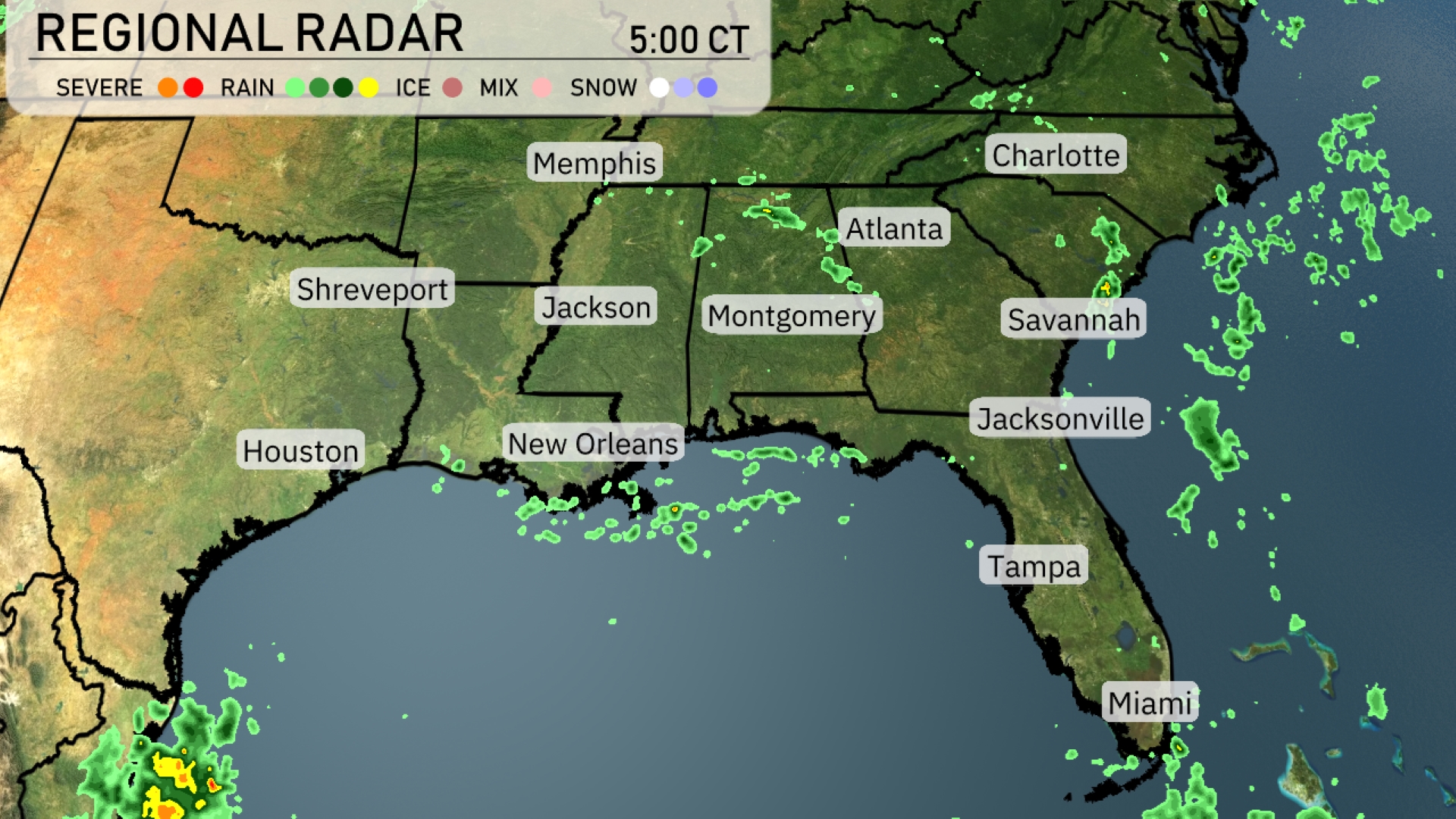
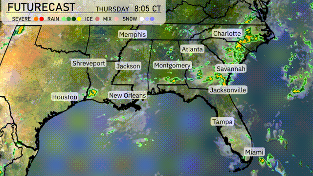
Across the Southeast, we see scattered showers popping up near New Orleans and stretching into parts of the Florida Panhandle. These showers are extending into the Gulf, forming a band that nudges gently towards the coast. In Georgia, particularly around Atlanta, light precipitation is developing, hinting at more widespread rain as the system progresses northeast. Meanwhile, Memphis and surrounding areas remain relatively dry, with a few clouds but no precipitation expected imminently.
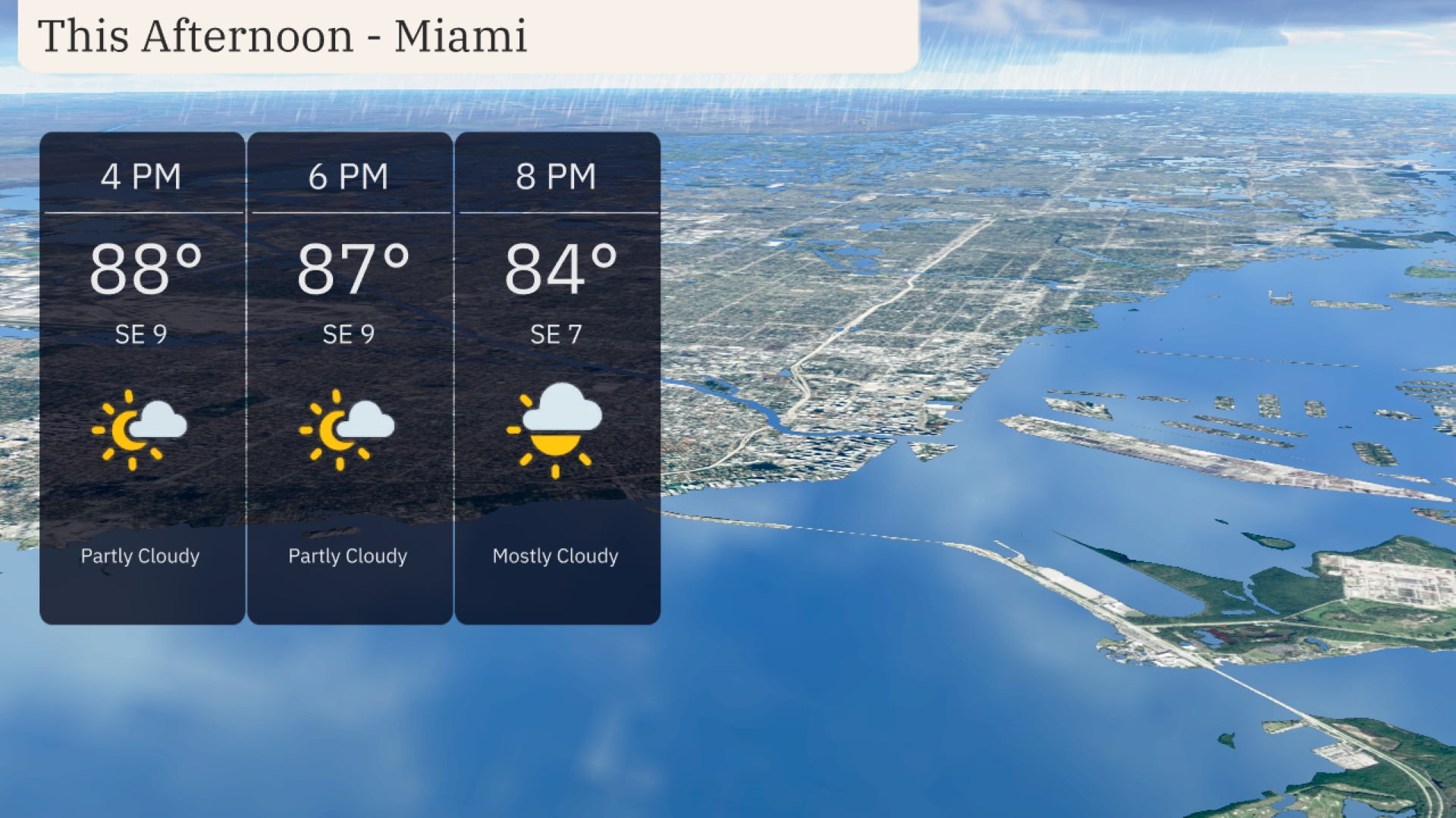
This afternoon in Miami, temperatures will hover around 88 degrees at 4 PM, cooling slightly to 87 degrees by 6 PM, and further to 84 degrees by 8 PM. Expect a partly cloudy sky initially, transitioning to mostly cloudy by the evening. Winds will remain gentle from the southeast direction at around 9 miles per hour, easing to 7 miles per hour late into the afternoon.
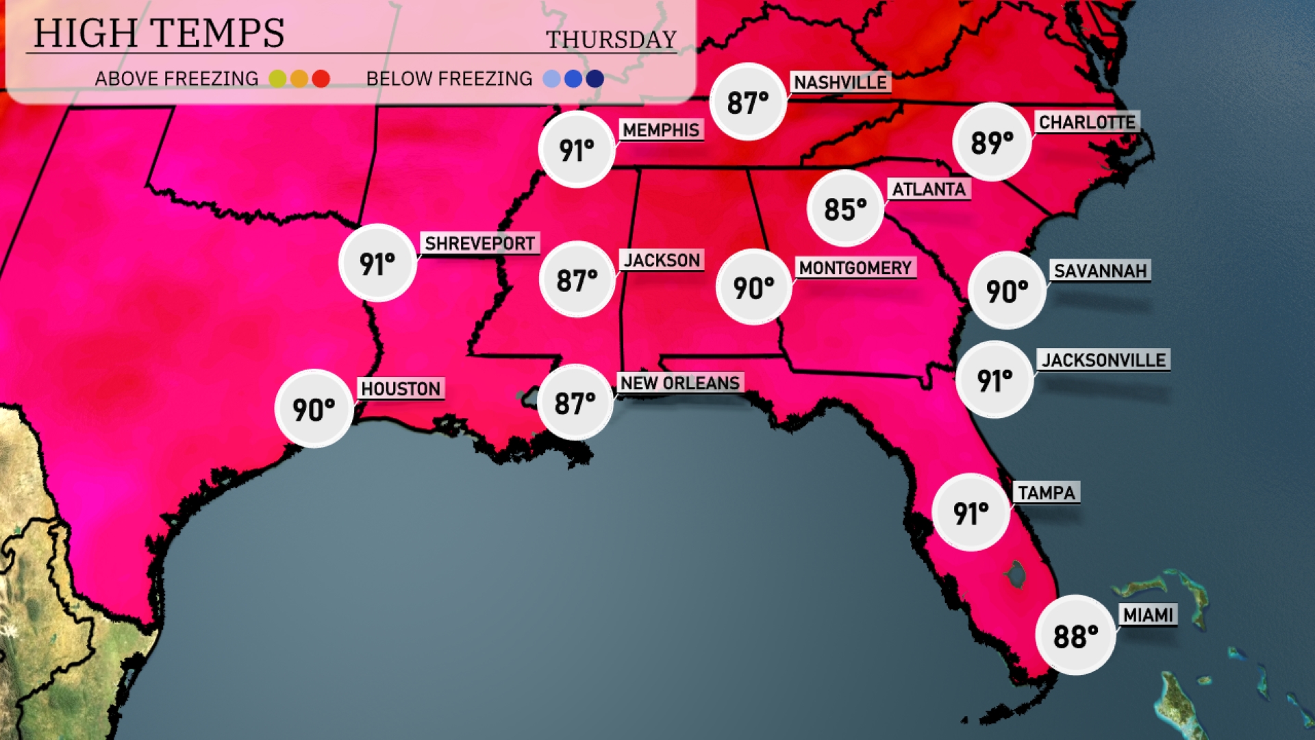
In the Southeast today, we’re seeing a range of warmer temperatures across the region. Jacksonville and Savannah are both hitting a high of 91 degrees, while Miami is a bit cooler at 88. Over in New Orleans, expect temperatures to reach 87 degrees, and in Jackson, we’re forecasting a high of 87 as well. Montgomery is slightly warmer today at 90 degrees, while Atlanta comes in at 85. It’s important to stay hydrated and be mindful of the heat, especially in these areas today!
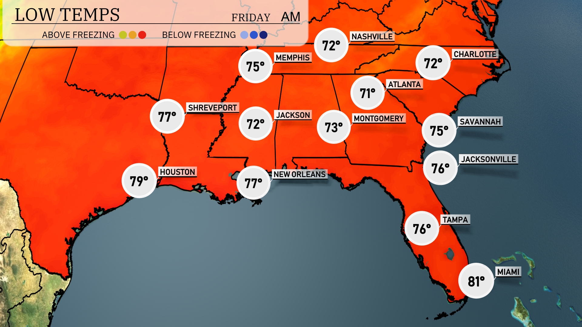
Tonight, temperatures are expected to dip to 72 degrees in Memphis and Nashville. Jackson will see a low of 72, while Montgomery dips to 73. Shreveport will stay warmer at 77 degrees, along with New Orleans also holding steady at 77. Expect mild conditions in the coastal cities, with Tampa at 76 and Miami remaining warm at 81 degrees.
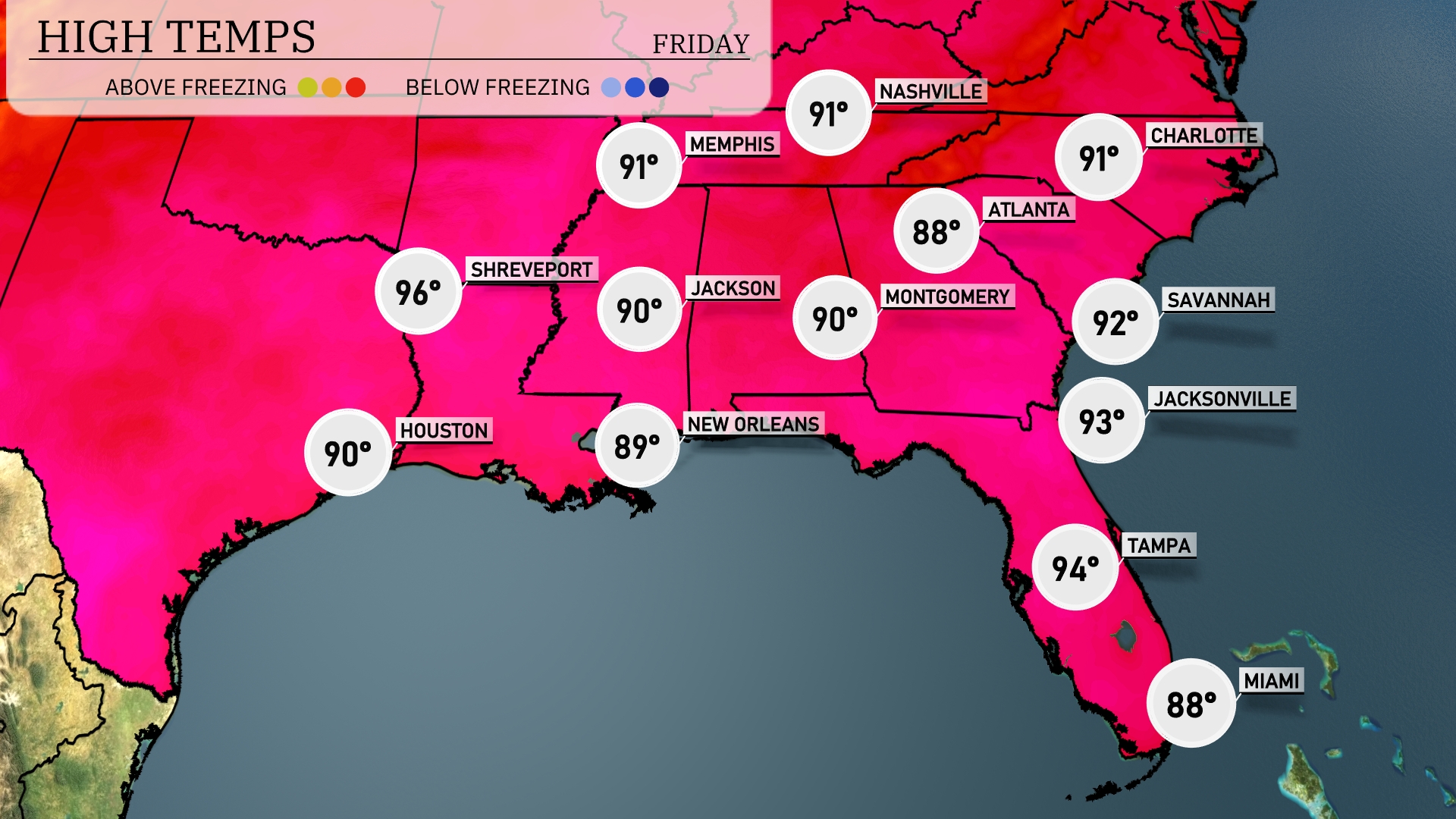
Tomorrow, Shreveport will experience a hot high of 96 degrees, while temperatures in Houston will reach a warm 90 degrees. Memphis is expecting a high of 91 degrees, and Nashville will also see highs around 91 degrees. Moving south, New Orleans will be slightly cooler at 89 degrees, and Montgomery will match that temperature. Jacksonville and Tampa can expect highs of 93 and 94 degrees respectively, indicating a trend of above-average temperatures across the Southeast due to persistent high pressure in the region.
A weather system is driving showers and thunderstorms into the Southeast from Louisiana to Georgia, including parts of Florida. Expect storms with heavy rain and localized flooding risks especially from Jackson to Jacksonville through Friday morning. A cold front stalls in the region, maintaining cloudy and damp conditions with cooler temperatures hovering in the mid-70s. Thunderstorms could produce gusty winds and brief downpours, especially through Alabama and Mississippi. The unsettled weather pattern holds through Friday evening, clearing up slightly by Saturday morning.
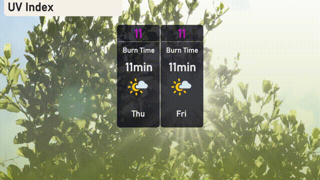
For Thursday in Miami, the UV index reaches an extreme level of 11, with sunburn possible in just 11 minutes. On Friday, be equally cautious as the index remains at 11. Consider wearing sunscreen, hats, and sunglasses to minimize exposure.