Breaking Weather: Sunny Miami and Storms Across the Southeast
By
Amy Freeze
Meteorologist Amy Freeze guides you through sunny spells in Miami and incoming storms across the Southeast. Stay prepared with our detailed forecast.
Catch up on Miami’s sunny forecast and the approaching storms across the Southeast in our latest weather report by Amy Freeze.
Welcome to your essential weather update with Amy Freeze. This afternoon in Miami, enjoy partly sunny skies before a line of storms makes its way towards the Southeast. We’re tracking rain in Houston, showers in Louisiana, and dry spells in Atlanta. With detailed insights on temperature changes and storm predictions, our forecast prepares you for each shift in the weather landscape from today through the next seven days. Stay informed and ready!
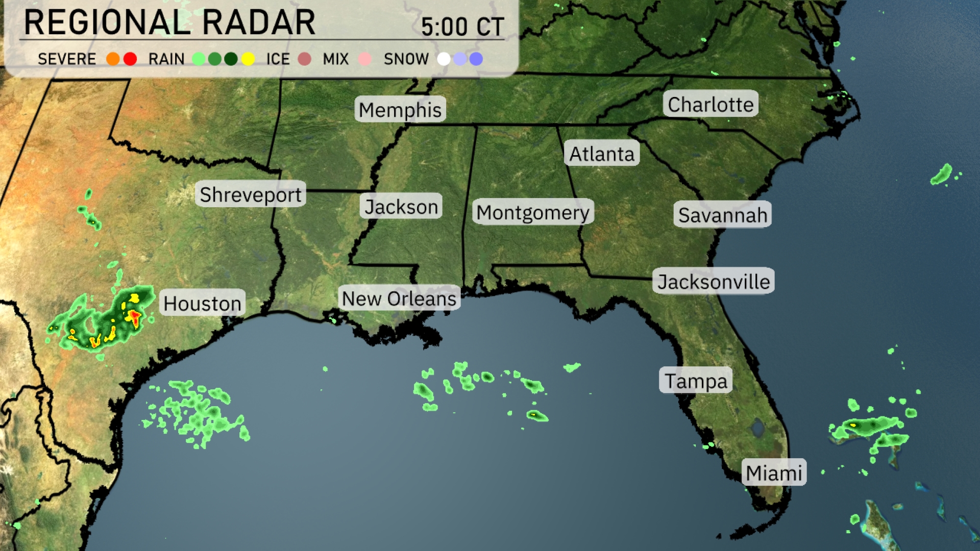
A line of storms is sweeping eastward towards Houston, with significant rainfall impacting the area. Meanwhile, light rain showers are developing off the coast of Louisiana and moving inland towards New Orleans. The rest of the Southeastern region, including cities like Atlanta, Charlotte, and Jacksonville, remains relatively cloud-free and dry for now. Coastal waters off Tampa and Miami are witnessing some rain showers, but these are not currently affecting the land. Prepare for changing weather conditions as these systems progress further inland.
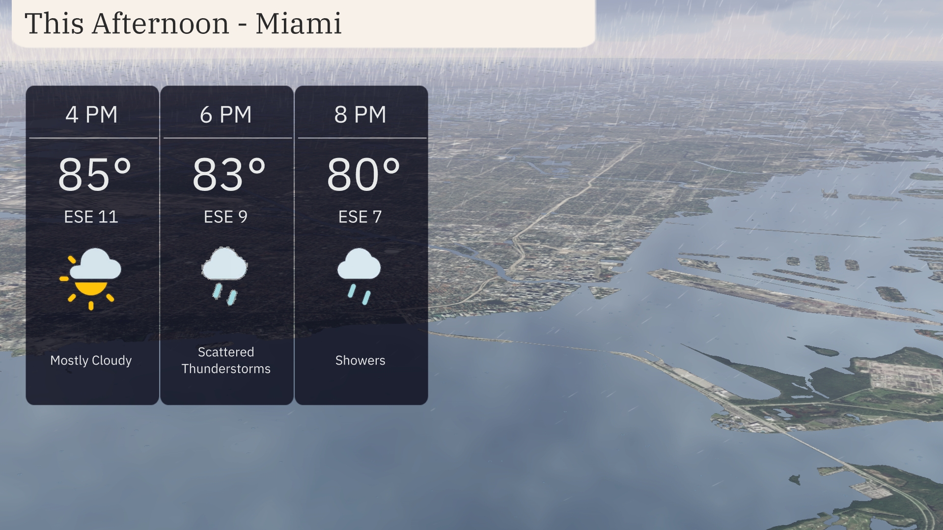
Temperatures in Miami this afternoon will be in the 80s, with a high of 85 degrees at 4 PM. Winds will be from the east-southeast at 11 mph, providing a gentle breeze under mostly cloudy skies. By 6 PM, temperatures dip to 83 degrees as scattered thunderstorms move into the area with east-southeast winds at 9 mph. Showers continue into the evening with a temperature of 80 degrees at 8 PM and winds easing to 7 mph.
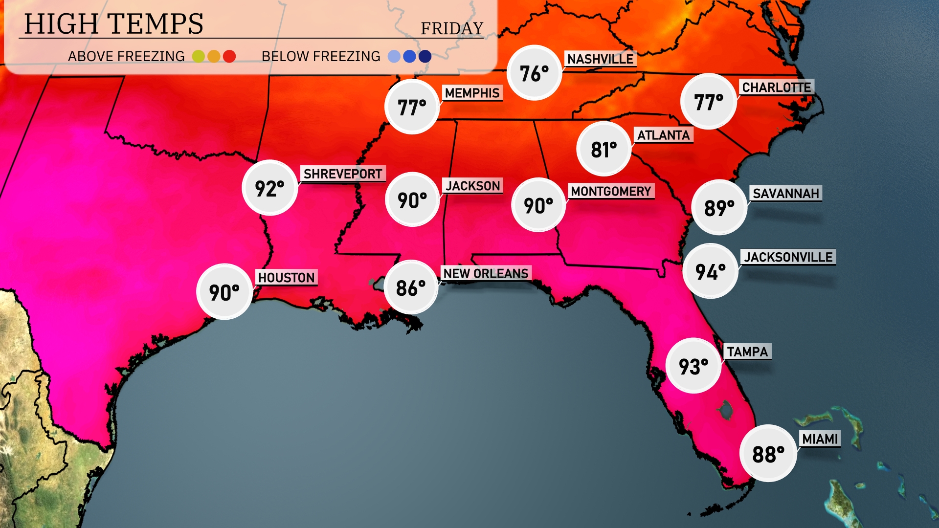
Today in New Orleans, expect a high of 86 degrees, while Houston will hit 90. Jackson and Montgomery are also forecasted to reach a warm 90 degrees. Over in Jacksonville, temperatures will soar to 94 degrees, making it one of the hottest spots in the region. To the northeast, Atlanta will enjoy milder weather with a high of 81 degrees. In contrast, Nashville is cooler, with a high of just 76 degrees as clouds linger.
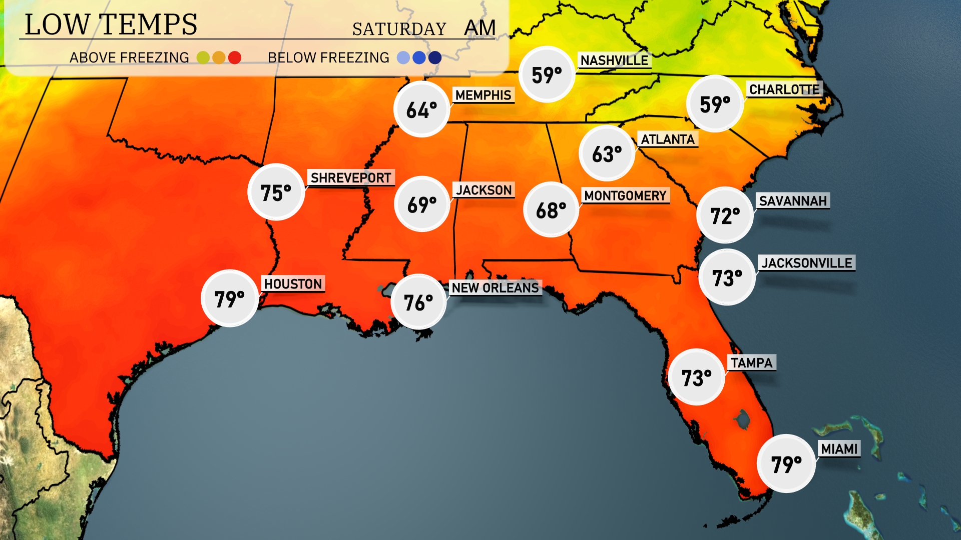
Tonight Memphis drops to 64 degrees, while Nashville sees a dip to 59 degrees. Montgomery will be at 68, and Jackson settles at 69 degrees. Savannah and Jacksonville remain warmer, with lows around 72 and 73 degrees, respectively. New Orleans will cool to 76, providing a comfortable but slightly cooler evening.
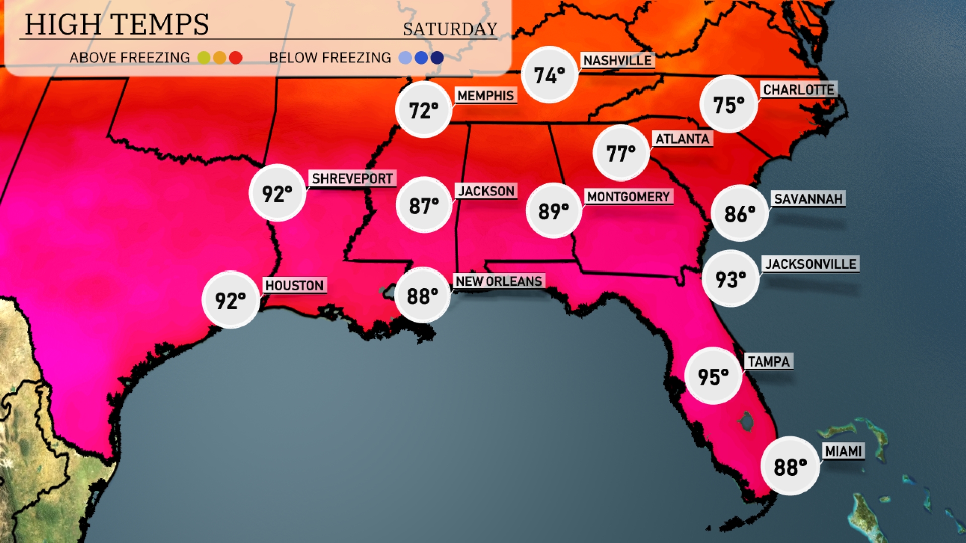
Tomorrow Atlanta can expect to reach a warm 77 degrees, while Memphis will hit 72. Montgomery temperatures will climb to 89 degrees, and New Orleans is forecasted at 88 degrees. Jacksonville will see a high of 93, and Tampa could reach a sizzling 95.
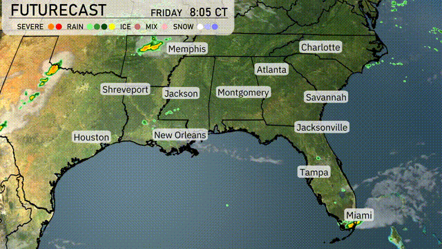
A frontal system is approaching the Southeast, bringing scattered storms and rainfall from Jackson to New Orleans by late Friday evening. Expect potential severe weather with gusty winds and heavy rain, particularly in southern Mississippi and Louisiana. As the front advances, areas from Atlanta to Charlotte might experience afternoon showers and thunderstorms on Saturday. Temperatures across the region will range from the mid-70s in Memphis to the upper 80s in Miami. By Saturday evening, the system moves east, bringing clearer skies and cooler conditions into Sunday.
The UV index in Miami today will be extreme at 11, with a burn time of about 11 minutes in direct sunlight.