Miami Shines while the Southeast Faces Stormy Weather Patterns
By
Amy Freeze
Explore how Miami enjoys sunny skies while neighboring regions brace for storms. Detailed forecasts inside!
In Miami, expect sunny skies with temperatures warming throughout the day, while the Southeast U.S. prepares for stormy weather. Read on for detailed city forecasts, temperature trends and safety tips.
Welcome to our detailed weather forecast with meteorologist Amy Freeze. Miami greets the day with sunshine and clear skies, promising pleasant temperatures. In contrast, the broader Southeast region faces storm challenges. From the gusty storms in New Orleans to the heavy rains across Mississippi and Alabama, get latest forecasts for key cities. Learn preparation tips for adverse weather conditions and how these patterns influence local temperatures. Keep updated with Amy Freeze’s weather insights.
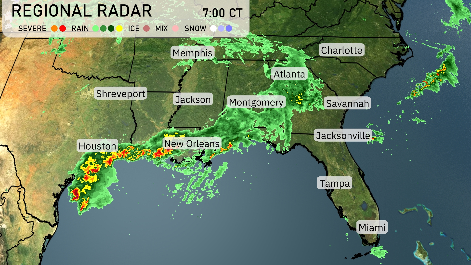
Along the Gulf Coast, New Orleans is experiencing heavy rain with periods of intense thunderstorms passing through. Rain showers extend into portions of Mississippi and Alabama, with Jackson and Montgomery both seeing consistent rainfall. Meanwhile, Atlanta and Charlotte are currently under the influence of widespread rain, which is gradually moving toward the eastern part of Georgia. In contrast, Tampa and Miami remain dry with clear skies, offering a pleasant start to the day.
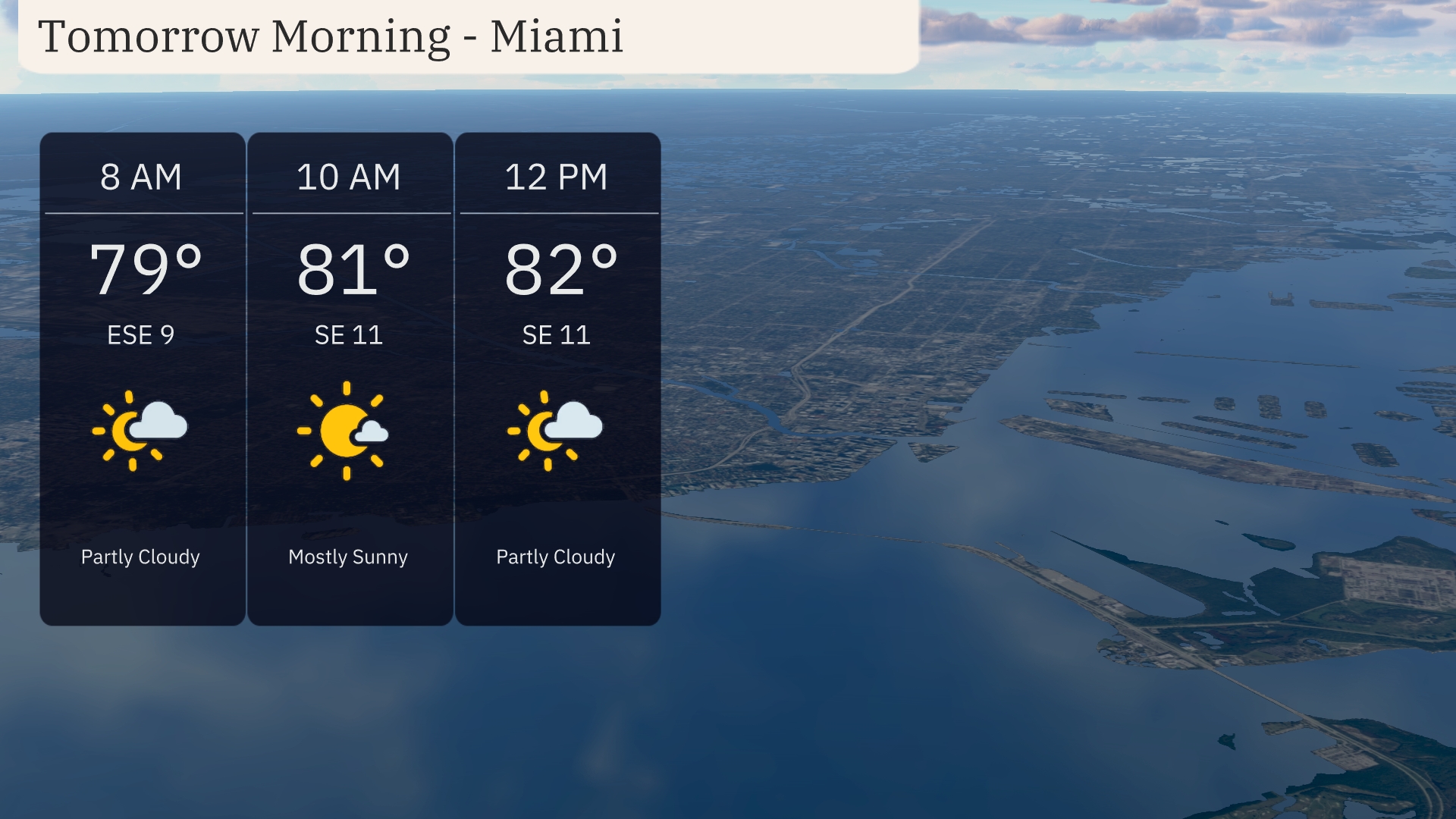
For tomorrow morning in Miami, temperatures will start at 79 degrees at 8 AM under partly cloudy skies with winds from the east-southeast at 9 miles per hour. By 10 AM, the temperature increases slightly to 81 degrees with mostly sunny skies, and winds shift to the southeast at 11 miles per hour. At midday, expect it to be 82 degrees with a mix of sun and clouds and continued southeast winds at 11 miles per hour.
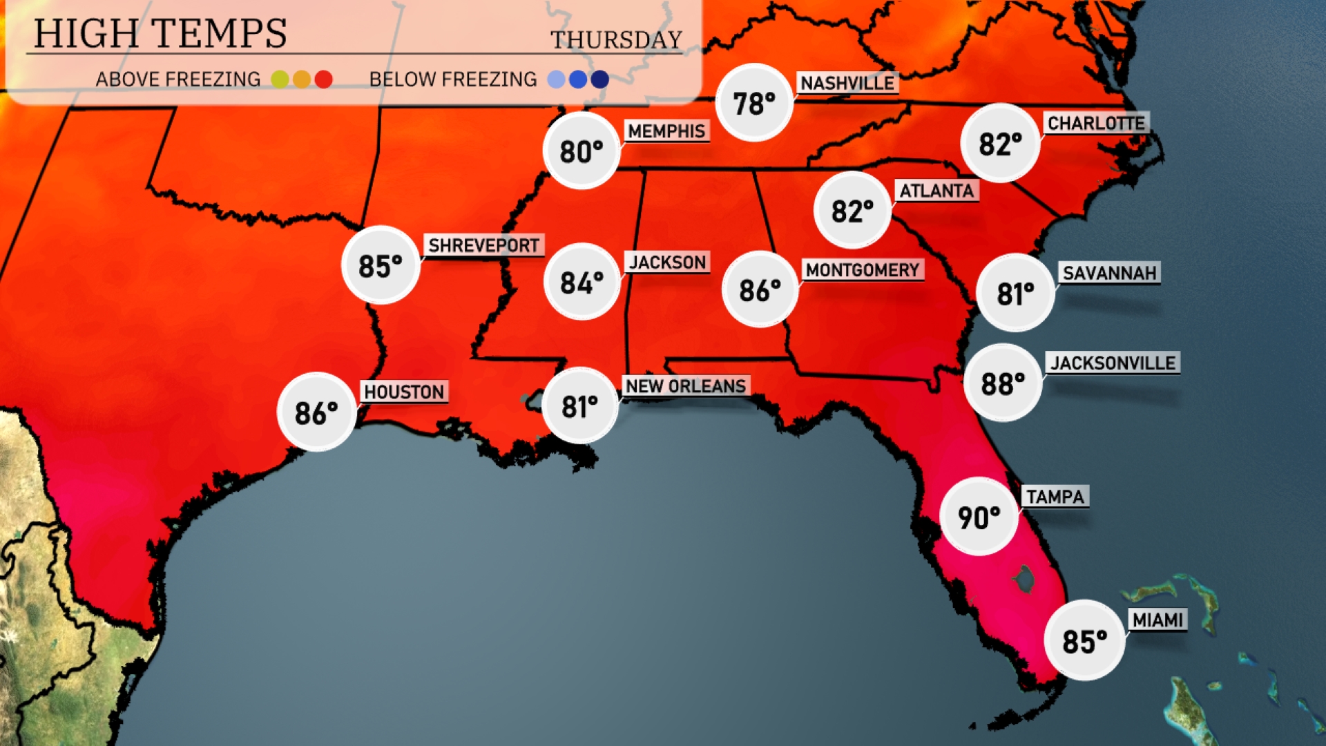
Tomorrow’s high temperatures in the Southeast will soar above average, bringing warm conditions across the region. Atlanta can expect a high of 82 degrees, while Nashville sees a pleasant 78 degrees. Over in Montgomery, temperatures are predicted to reach 86 degrees, and Jacksonville will be on the warmer side at 88 degrees. Tampa is set to hit a sweltering 90 degrees, making it one of the hottest spots in the region. A combination of high pressure and sunny skies will influence these above-normal temperatures throughout the Southeast.
A cold front is pushing through the Southeast, bringing thunderstorms from New Orleans to Atlanta. Heavy rain is anticipated early Wednesday across Mississippi and Alabama, moving into Montgomery during the morning commute. Isolated severe storms with gusty winds may occur, particularly around Gulfport and Mobile. Expect accumulations near 1 to 2 inches, potentially causing localized flooding in low-lying areas. Post-front, cooler and drier air settles in, with temperatures dropping by 5 to 10 degrees as skies clear by late Wednesday into Thursday.
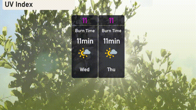
The UV index in Miami is peaking at 11, making it very high on both Wednesday and Thursday. Expect a quick burn time of just 11 minutes in direct sunlight, so it’s essential to apply sunscreen generously and seek shade during midday hours.
For the 7-day forecast in Miami:
Wednesday: Partly cloudy with a high of 83 degrees and a low of 76.
Thursday: Expect partly cloudy skies again, with the high reaching 84 degrees and a low of 77.
Friday: Another day of partly cloudy weather with temperatures climbing to 84 degrees and a nighttime low of 77.
Saturday: Continued partly cloudy conditions, look for a high of 84 degrees and a low of 78.
Sunday: Mostly cloudy skies, maintaining a high of 84 degrees and a low of 78.
Monday: Look out for scattered thunderstorms with a high of 83 degrees and a low of 77.
Tuesday: Thunderstorms late in the day, temperatures will reach a high of 83 degrees with a low of 76.