Miami Weather Tonight: Clear Skies and Gentle Breezes
By
Amy Freeze
Experience the serene evening weather in Miami as we cover the subtle shifts and prepare for scattered showers across the Southeast. From city sunsets to incoming storms, here's what to expect.
Tonight’s weather in Miami looks promising with mostly clear skies and a gentle southeast breeze. Find out more about what’s happening weather-wise across the Southeast in our full blog post!
Welcome to your detailed evening weather report for Miami and the broader Southeast as of July 21, 2025. Tonight, Miami delights with partly cloudy skies and a soft breeze, perfect for an evening stroll along the beach. Meanwhile, a quick glance over the Southeast reveals varying conditions—from scattered showers in Jacksonville to dry spells in Memphis and Houston. Dive deeper into our forecast to uncover what the rest of the week holds, especially with a weak cold front on the horizon promising scattered thunderstorms.
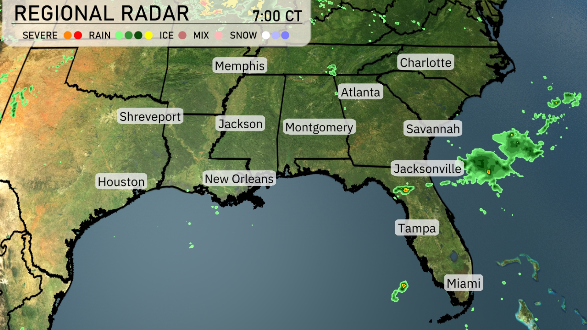
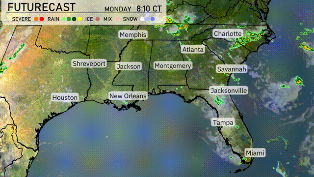
Across the Southeast, the radar displays scattered showers primarily affecting Jacksonville, moving inland from the Atlantic. Atlanta and Charlotte are under increasing cloud cover, preparing for incoming rain later in the day. While Memphis and Shreveport are currently dry, some scattered showers are lingering along the Gulf Coast, particularly near New Orleans. Houston remains clear, but eyeing a potential for storms developing to the west.
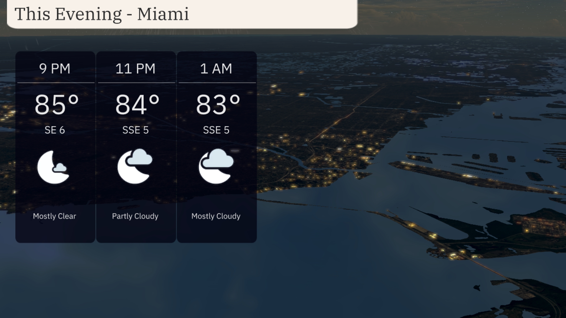
This evening in Miami, expect mostly clear skies at 9 PM with temperatures around 85 degrees and a southeast wind at 6 mph. By 11 PM, clouds begin to increase, bringing partly cloudy conditions with temperatures easing to 84 degrees and a south-southeast wind at 5 mph. As we approach 1 AM, skies become mostly cloudy, with temperatures slightly cooling to 83 degrees and consistent light breezes from the south-southeast.
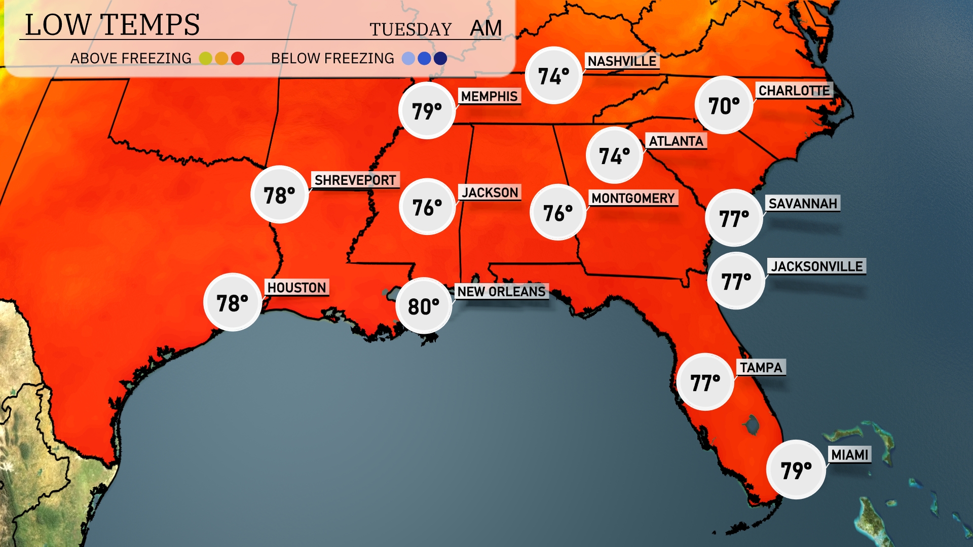
Tonight, Memphis is expected to cool down to 74 degrees. Atlanta will also see a low of 74 degrees, while Montgomery will drop to 76. Both Jackson and Shreveport will stay a bit warmer with lows around 78 degrees. Expect temperatures to remain slightly milder in New Orleans at 80 degrees and in Miami at 79.
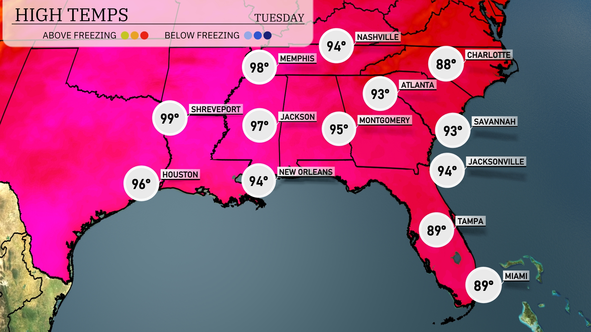
Tomorrow in the Southeast, we’ll see some scorching highs. Shreveport is leading the pack with a sizzling 99 degrees, while Jackson is expected to hit 97 degrees. In New Orleans, temperatures will reach 94 degrees, and Montgomery will see a high of 95. Atlanta is slightly cooler at 93 degrees, with Savannah also expecting 93 degrees.
A weak cold front approaches the Southeast, bringing scattered thunderstorms and showers, primarily impacting areas from New Orleans to Atlanta on Tuesday. Expect the heaviest rainfall between Montgomery and Jacksonville, with potential downpours throughout the afternoon. Spotty storms could cause brief gusty winds and isolated flooding in low-lying areas. Afternoon highs will remain in the high 80s to low 90s, with cooler and drier air arriving late Wednesday.
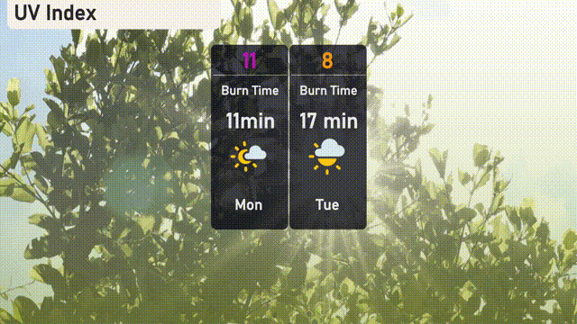
This Monday in Miami, we’re seeing an extreme UV index of 11, so sunburn could occur in just 11 minutes. For Tuesday, the UV index remains high at 8, with sunburn possible in about 17 minutes.
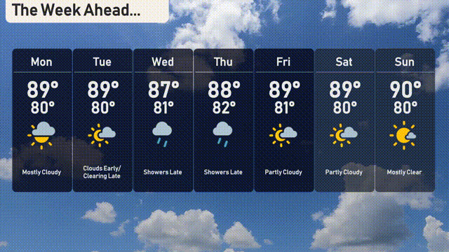
For the 7 Day Outlook in Miami:
Monday: Mostly cloudy with a high of 89 degrees and a low of 80 degrees.
Tuesday: Clouds early, but clearing late. High of 89 degrees and a low of 80 degrees.
Wednesday: Watch for showers late, with a slightly cooler high of 88 degrees and a low of 82 degrees.
Thursday: Showers continue late, with temperatures peaking at 88 degrees and dipping to 81 degrees overnight.
Friday: Partly cloudy skies, expect a high of 89 degrees and a low of 81 degrees.
Saturday: Partly cloudy with a daytime high of 89 degrees and a nighttime low of 80 degrees.
Sunday: Mostly clear skies to round out the week with a high of 90 degrees and a low of 80 degrees.