Weather Watch: Miami’s Evening Forecast and Week Ahead with Amy Freeze
By
Amy Freeze
Meteorologist Amy Freeze provides an in-depth look at the weather conditions sweeping across Miami and the Southeast, detailing evening temperatures, storm predictions, and much more.
Catch the latest weather updates for Miami with Amy Freeze! Discover the detailed forecast for tonight and the upcoming week as we tackle temperatures, storms, and sunshine.
Welcome to your comprehensive weather guide for Miami and the Southeast, brought to you by meteorologist Amy Freeze. Tonight, Miami can expect warm temperatures with partly cloudy skies transitioning throughout the evening. The region sees varied weather with storms lined up from Houston to Montgomery. Keep reading to uncover detailed forecasts for further insights into the potential morning commutes affected by early thunderstorms, and what the week ahead holds in terms of weather patterns across Miami and neighboring states.
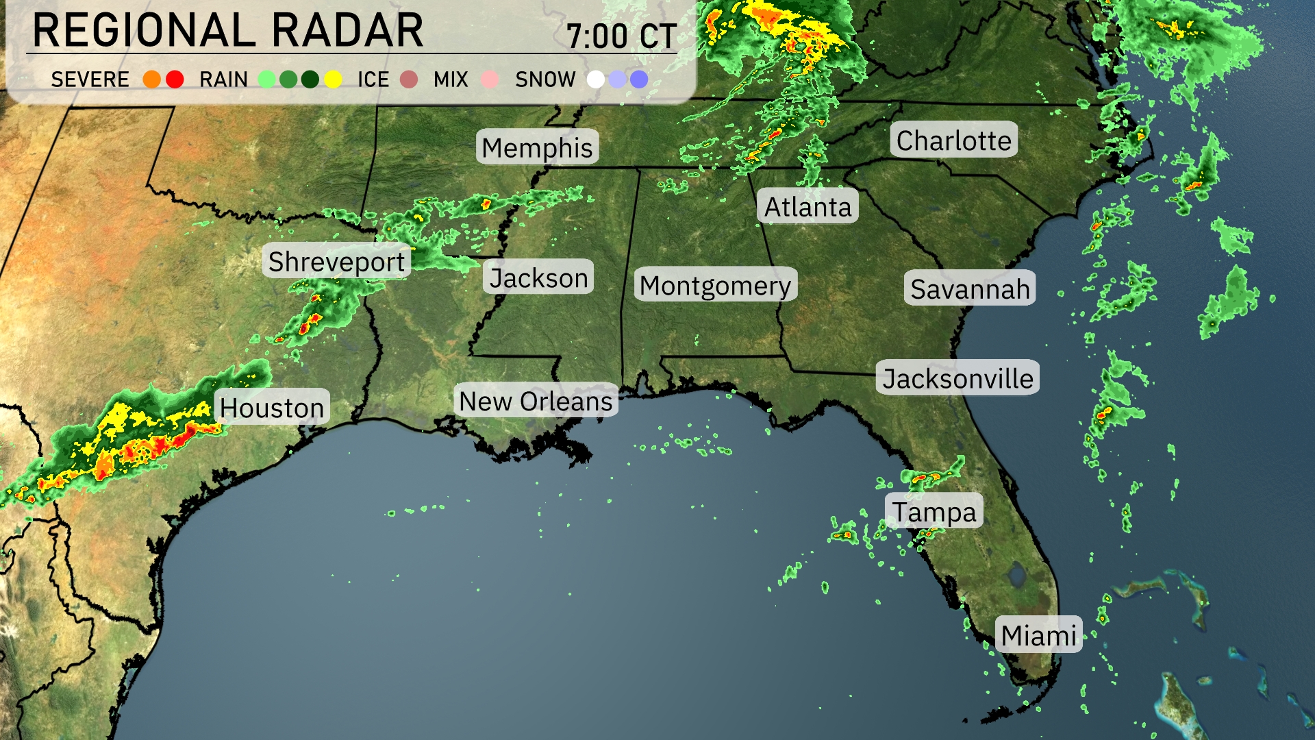
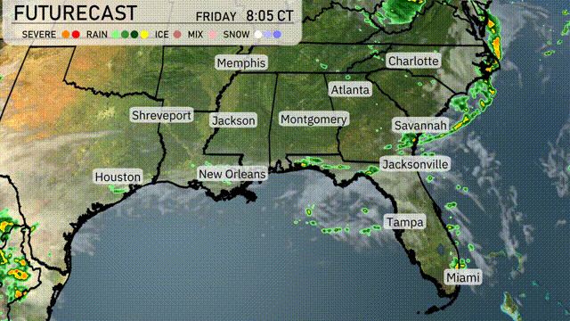
An active weather system is bringing rain and thunderstorms across parts of the Southeast. Houston is under a line of severe storms moving eastward. Showers and storms are advancing from Shreveport towards Jackson. Over in the eastern portion of the region, Charlotte and Montgomery are experiencing rain showers as a line of precipitation stretches across the states. Areas like Savannah, Jacksonville, and Miami are currently clear.
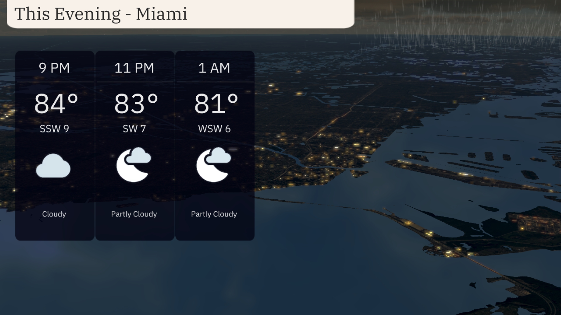
This evening in Miami, temperatures will remain warm, beginning at 84 degrees at 9 PM and gradually dipping to 81 degrees by 1 AM. Expect a cloud cover with mostly cloudy skies transitioning to partly cloudy conditions as the night progresses. Winds are breezy, coming from the south-southwest at 9 miles per hour initially and shifting to west-southwest at 6 miles per hour overnight.
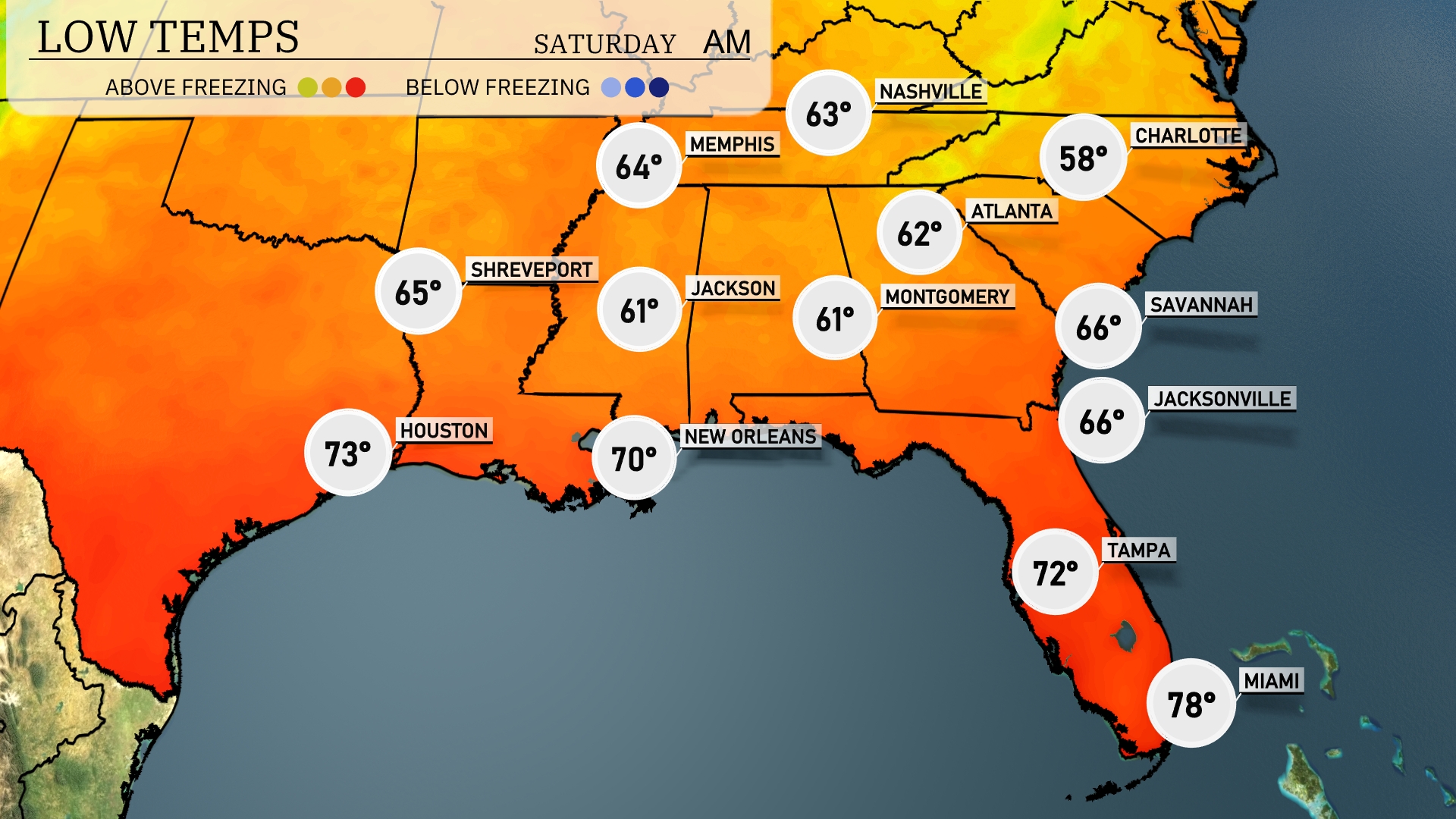
Tonight Nashville will see a low of 63 degrees, while Atlanta cools to 62. In Alabama, Montgomery will reach 61 degrees and Jackson, Mississippi, will also experience a low of 61. Further south, New Orleans stays warmer at 70 degrees, but Tampa on the Gulf Coast will see a low of 72. Miami remains mild at 78 degrees,
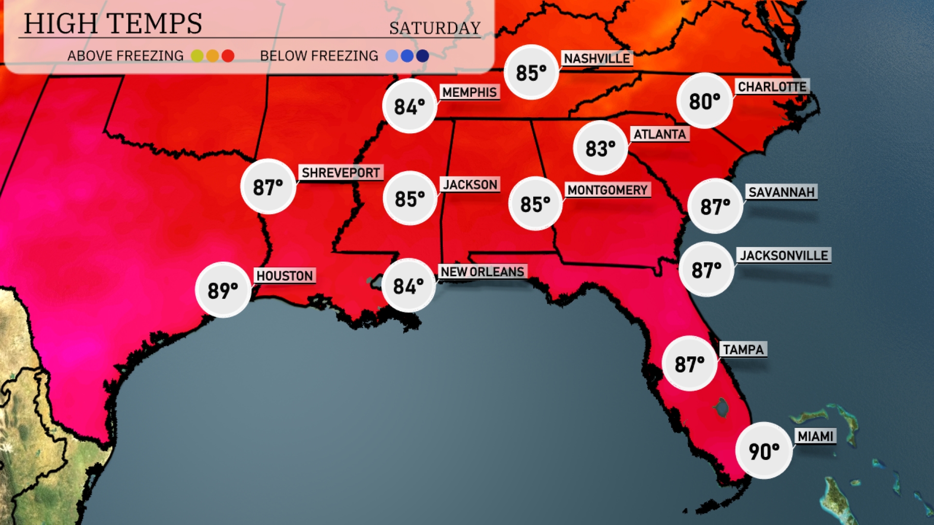
Tomorrow Atlanta will reach 83 degrees, while Jacksonville and Savannah could see highs of 87 degrees. Houston is set to have a high of 89 degrees, and New Orleans will reach 84 degrees. Miami stands out with a sizzling high of 90 degrees, reinforcing the warm trend across the region.
A line of storms will stretch from New Orleans to Montgomery tomorrow, as a cold front moves in from Texas across the Southeast. Expect scattered thunderstorms in areas from Jackson to Atlanta early in the day, potentially causing disruptions during the morning commute. Heavy downpours could lead to localized flooding, particularly in lower-lying areas. As the front progresses, the threat of severe thunderstorms, with gusty winds and hail, will increase across Alabama and Georgia. By evening, conditions should begin to clear, bringing a drop in temperatures and calmer skies.
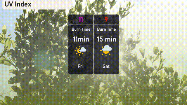
For your Friday in Miami, the UV index is extremely high at 11, indicating a risk of skin damage with only 11 minutes of direct sun exposure. Saturday sees a slightly lower UV index of 9, where you’ll still find a burn risk in about 15 minutes of sunshine.
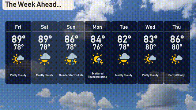
For the 7-day outlook in Miami:
Friday: Partly cloudy skies with a warm high of 89 degrees and a low of 78 degrees.
Saturday: Mostly cloudy conditions, maintaining a high of 89 degrees and a low of 78 degrees..
Sunday: Thunderstorms roll in with temperatures reaching 86 degrees for the high and 78 degrees for the low.
Monday: Scattered thunderstorms continue with a high of 84 degrees and a low of 76 degrees.
Tuesday: Thunderstorms persist, with temperatures around 82 degrees and a low of 77 degrees.
Wednesday: Partly cloudy skies as the weather clears, with a high of 83 degrees and a low of 79 degrees.
Thursday: The week rounds off with partly cloudy conditions and temperatures rising slightly to a high of 86 degrees and a low of 80 degrees.