Navigating Through Clouds: Miami’s Evening Weather and Week Ahead
By
Amy Freeze
Explore the shifting skies of Miami with our evening and weekly weather forecast - thunderstorms included! Learn how to stay prepared and comfortable amidst Florida's ever-changing climate.
Tonight in Miami, anticipate partly cloudy skies with a warm touch as we discuss storm predictions and temperature gradients across the Southeast.
This detailed post reveals the intricacies of Miami’s evening and weekly weather patterns. From tonight’s mild temperatures to the promise of an active weather week, we cover the essentials of what to expect across the region, including severe thunderstorm alerts and climate safety tips. Dive deep into our analysis as we prepare you for a week of diverse weather in Florida.
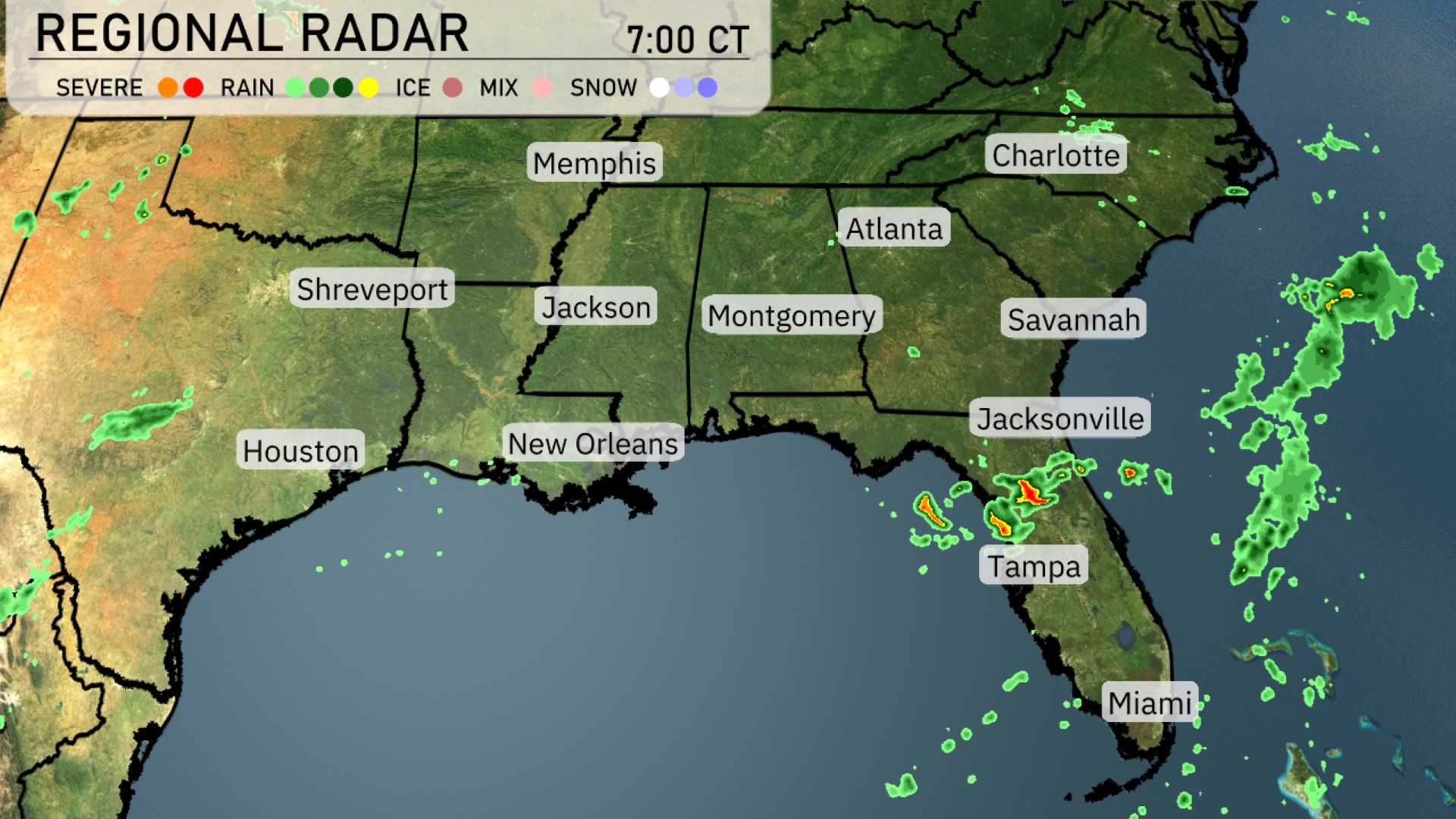
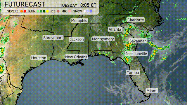
A line of thunderstorms is moving across the Gulf of Mexico towards Florida, bringing significant rain to the Tampa area. Heavier pockets of rain with potential severe thunderstorms are forming just off the coast of Jacksonville, gradually moving northward. Meanwhile, it’s mostly clear over New Orleans and Houston, providing a break from stormy conditions. Light precipitation is also scattered around eastern Louisiana.
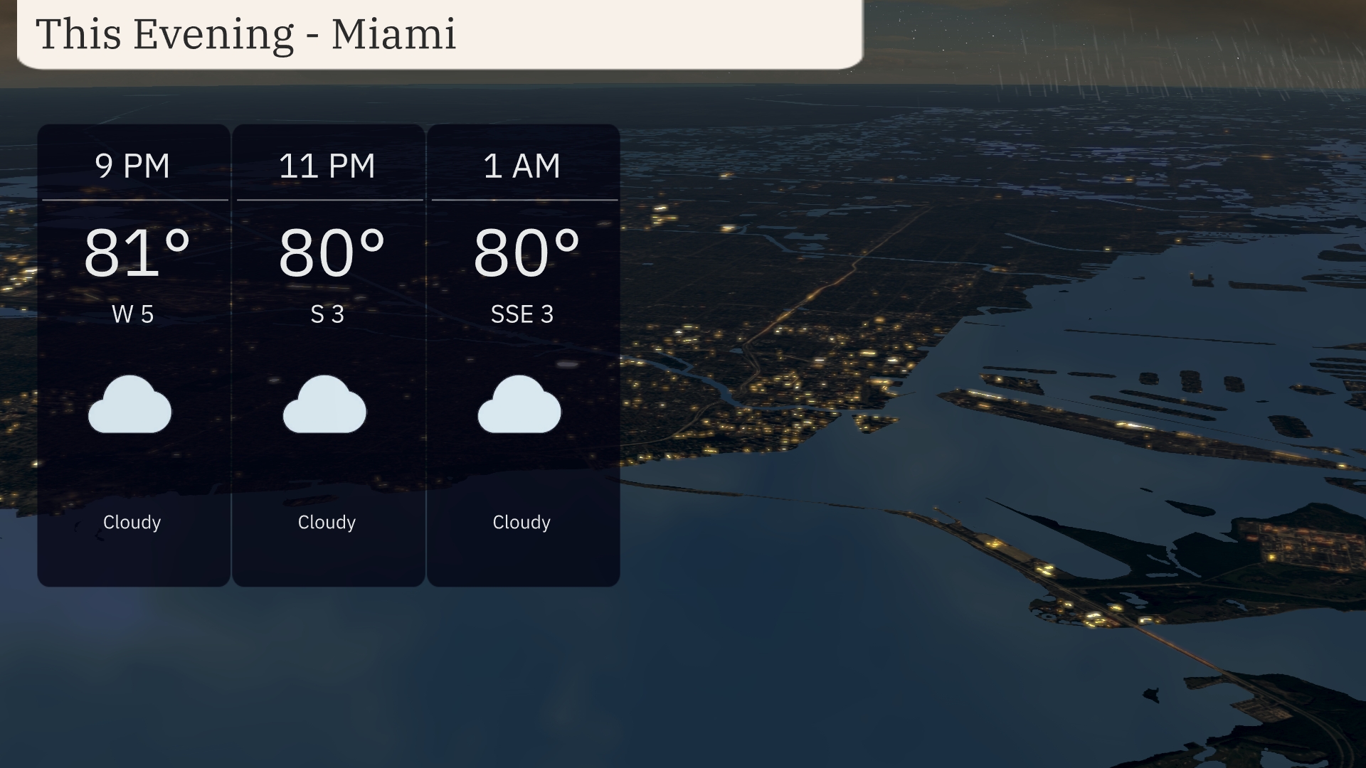
Temperatures in Miami this evening remain warm, holding steady around 81 degrees at 9 PM, and gently decreasing to 80 degrees by 1 AM. Expect persistent cloud cover throughout the evening. Winds are mild, shifting from the west at 5 mph to a gentle south-southeast breeze at 3 mph. A calm and cloudy night is on the cards, perfect for indoor relaxation.
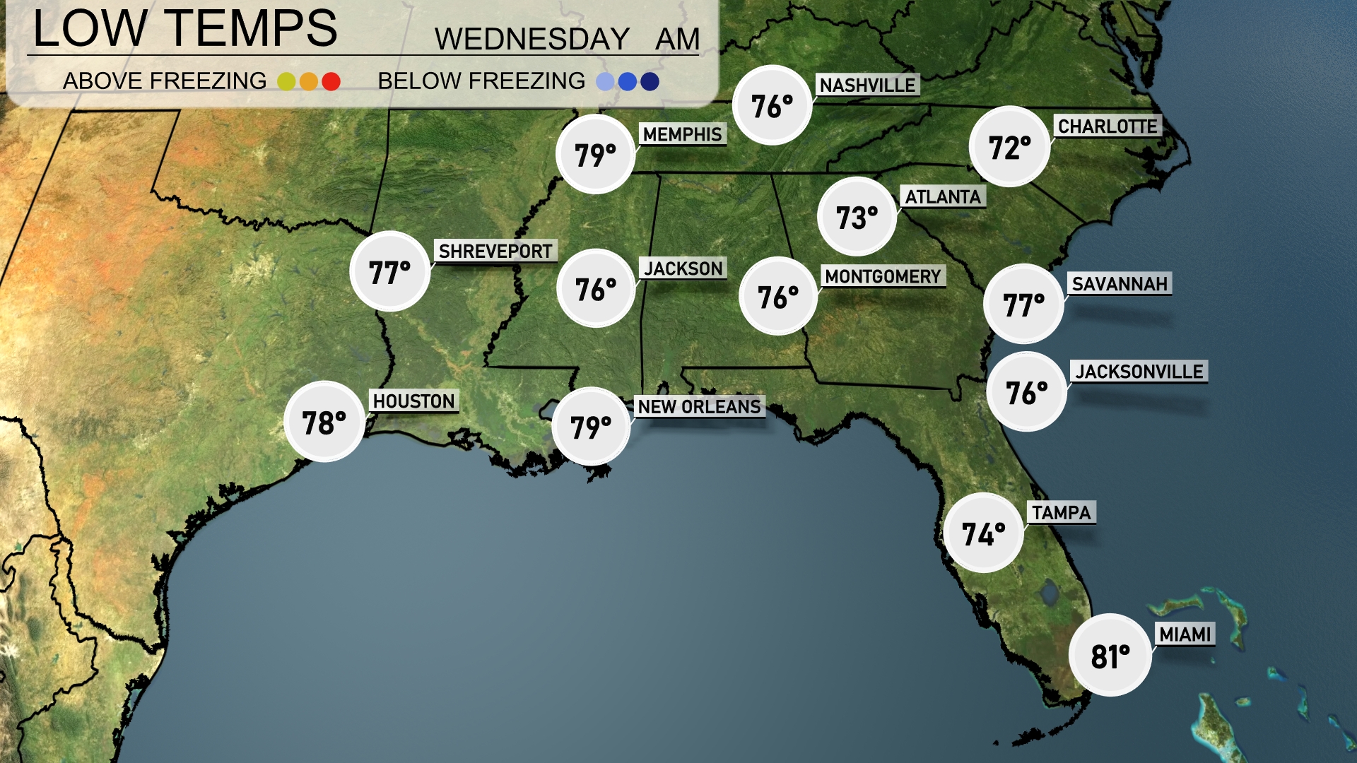
Tonight, temperatures in the Southeast will drop significantly, with Memphis seeing a low of 76 degrees. Jackson is expected to cool down to 76, while Montgomery will also drop to 76 degrees. In Florida, Tampa will cool to 74 degrees and Jacksonville is set for a low of 76. Expect a milder night in Miami, with temperatures only falling to 81 degrees.
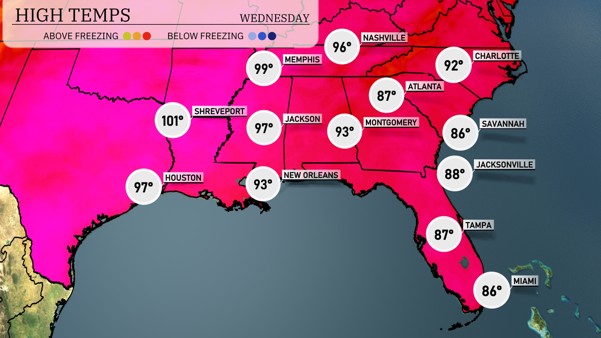
Tomorrow, Memphis will reach a scorching high of 99 degrees, with Shreveport even hotter at 101. Houston isn’t far behind, expecting a high of 97 degrees. In contrast, Atlanta will have a warm but slightly more moderate day with a high of 92. Further south, Miami will see temperatures peaking at 86 degrees, while Jacksonville rounds it out with a high of 88.
Across the Southeast, expect an active weather day with showers and thunderstorms from Jacksonville to Savannah. A cold front moves into the region, bringing embedded thunderstorms as it advances eastward from Shreveport and New Orleans towards Atlanta and Montgomery. This weather system could produce heavy downpours and gusty winds, increasing the risk of localized flooding. In Miami, the weather remains relatively dry and warm, though scattered thunderstorms are possible. Keep an eye on conditions, especially in areas prone to flash flooding.
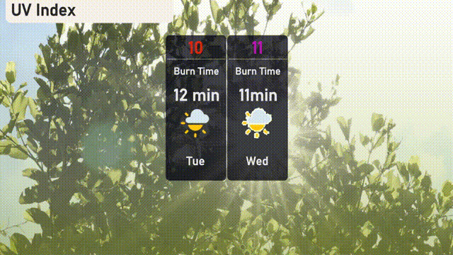
In Miami, the UV index is expected to be very high at 10 on Tuesday and jumps to 11 on Wednesday. On Tuesday, expect a burn time of 12 minutes, which decreases to just 11 minutes on Wednesday. It’s crucial to apply sunscreen regularly and stay in the shade when possible to protect against harmful UV rays!
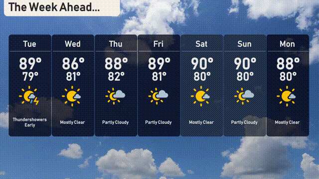
For the 7-day forecast in Miami:
Tuesday: Expect thundershowers early with a high of 89 degrees and a low of 79 degrees.
Wednesday: Mostly clear conditions prevail, with the temperature reaching 88 degrees and a low of 81 degrees.
Thursday: Another chance for a partly cloudy day, peaking at 88 degrees, with a low of 82 degrees.
Friday: Partly cloudy skies continue, with temperatures rising to 89 degrees and dropping to 81 degrees at night.
Saturday: Mostly clear skies brighten the day, with a high of 90 degrees and a low near 80 degrees.
Sunday: A mostly sunny and pleasant day anticipated, the high reaching 90 degrees, cooling to 80 degrees.
Monday: The start of the week sees mostly clear skies, with temperatures hitting 88 degrees and a nighttime low of 80 degrees.