Mysteries of Miami’s Weather: From Sunny Skies to Stormy Horizons
By
Amy Freeze
Unveiling the fluctuating weather conditions in Miami and across the Southeast, from sun-filled afternoons to impending thunderstorms. Get the latest insights into what’s brewing in your skies!
Miami greets the day with partly cloudy skies and a promise of a warm 87 degrees. Throughout the Southeast, weather patterns showcase storms and clear skies. Tonight, expect various temperature dips across cities, with Miami holding warm at 79 degrees.
This week, Miami’s skies are showcasing a palette of conditions. Today, expect partly sunny scenarios with a breeze cutting through the humidity. Look forward to a mixed bag of showers and clear skies across the region with temperatures peaking at 87 degrees. Diving deeper into the week, a cold front may introduce more robust storm activities, affecting extensive areas from Houston to Savannah. Always be prepared with the latest updates and insights, only here at https://amyfreeze.ai/
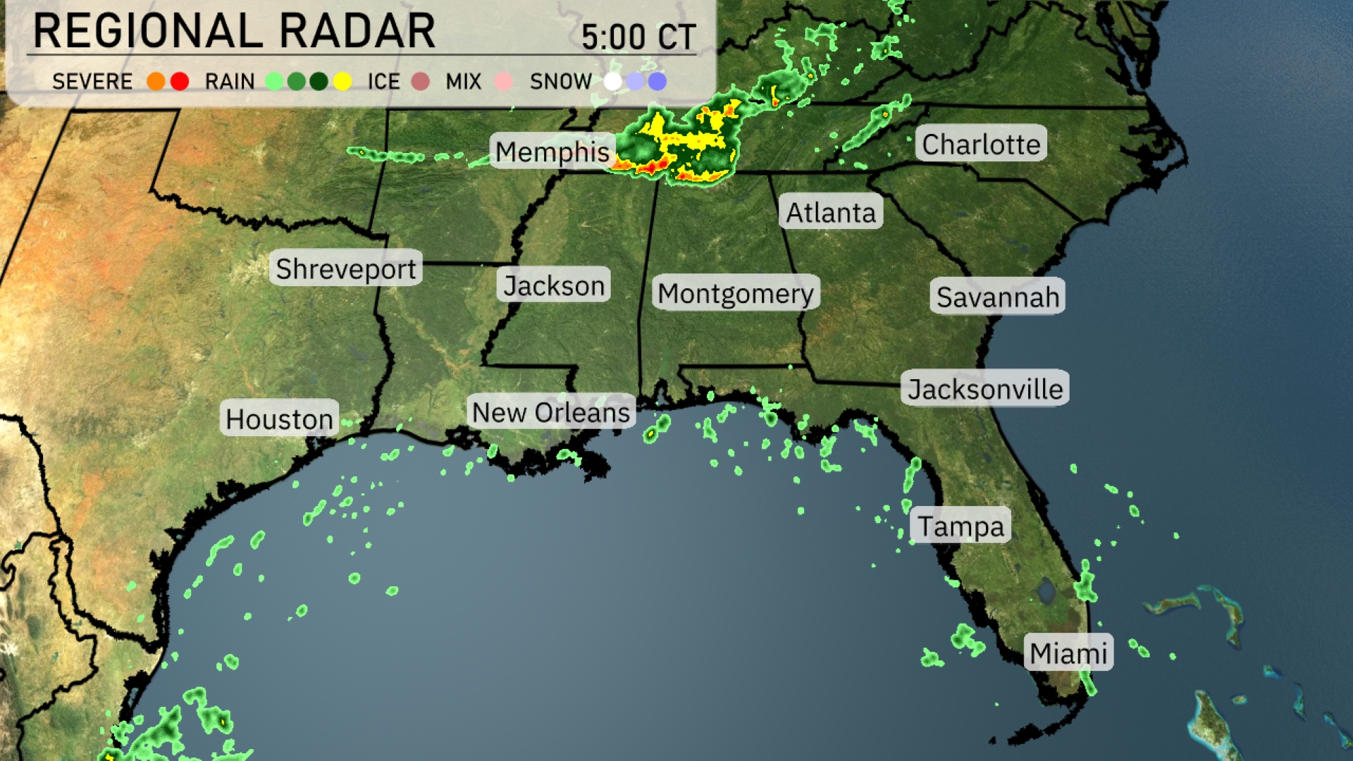
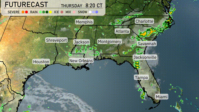
The Southeast region is experiencing a dynamic weather pattern this morning. Storms are concentrated around Memphis, moving towards the northeast with vigorous intensity. While Shreveport enjoys clearer skies, showers are sweeping through central Mississippi and moving towards Jackson. Additionally, the light rain is developing near New Orleans, indicating a wet day ahead for the Gulf Coast.
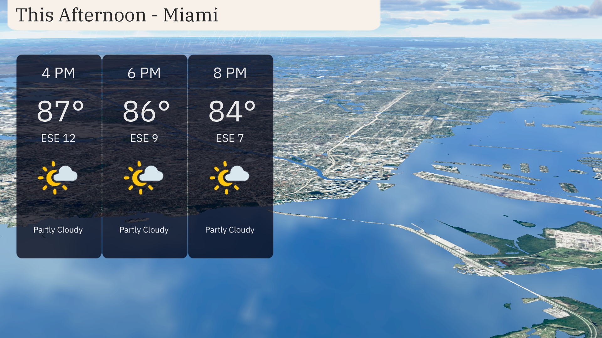
Temperatures in Miami for this afternoon will be warm, starting at 87 degrees by 4 PM and cooling slightly to 84 degrees by 8 PM. Expect partly cloudy skies with a comfortable breeze from the east-southeast, averaging 12 miles per hour at 4 PM and decreasing to 7 miles per hour by 8 PM.
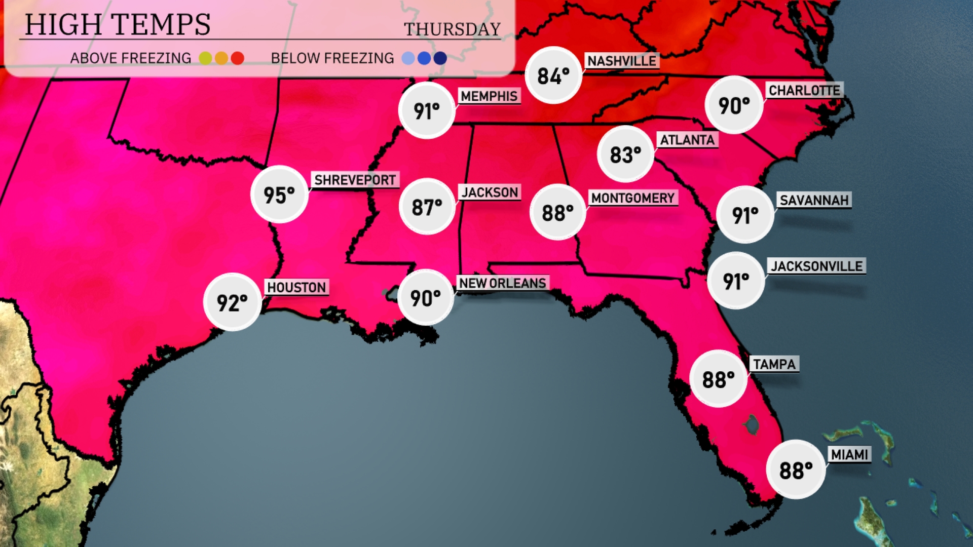
Today’s high temperatures are impressive across the Southeast. Shreveport is heating up to a sweltering 95 degrees, while Houston will experience a warm 92. New Orleans and Jackson will both reach around 90 and 87 degrees respectively. The coastal cities are enjoying slightly cooler temperatures, with Tampa and Miami settling at a comfortable 88 degrees. Savannah and Jacksonville are tied at 91 degrees, showcasing the typical summertime warmth in the region.
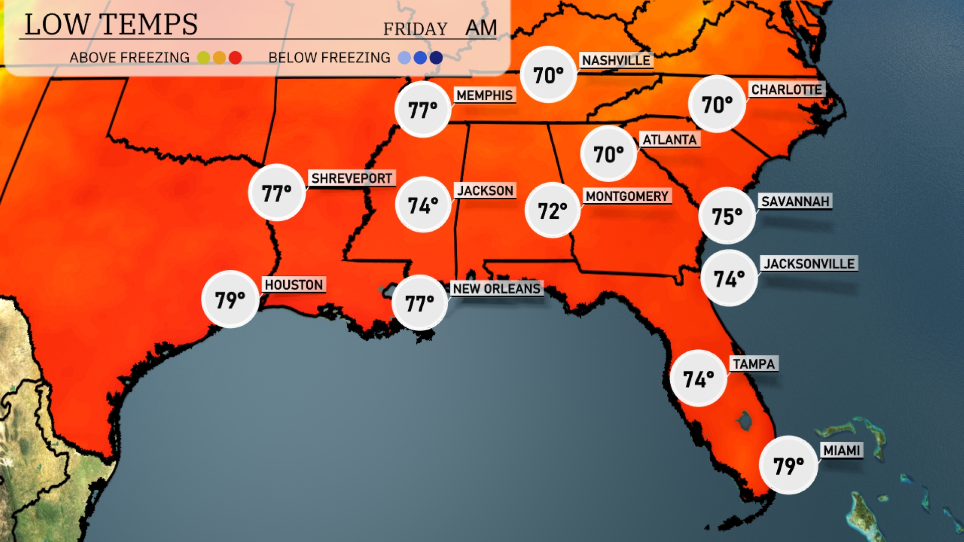
Tonight, Memphis will fall to 74 degrees, while Nashville sees a low of 70. Expect Jackson to cool down to 74, with Montgomery slightly cooler at 72. Atlanta will register a low temperature of 70 degrees, and farther south, Tampa remains comfortably warm at 74 with Miami at 79 degrees.
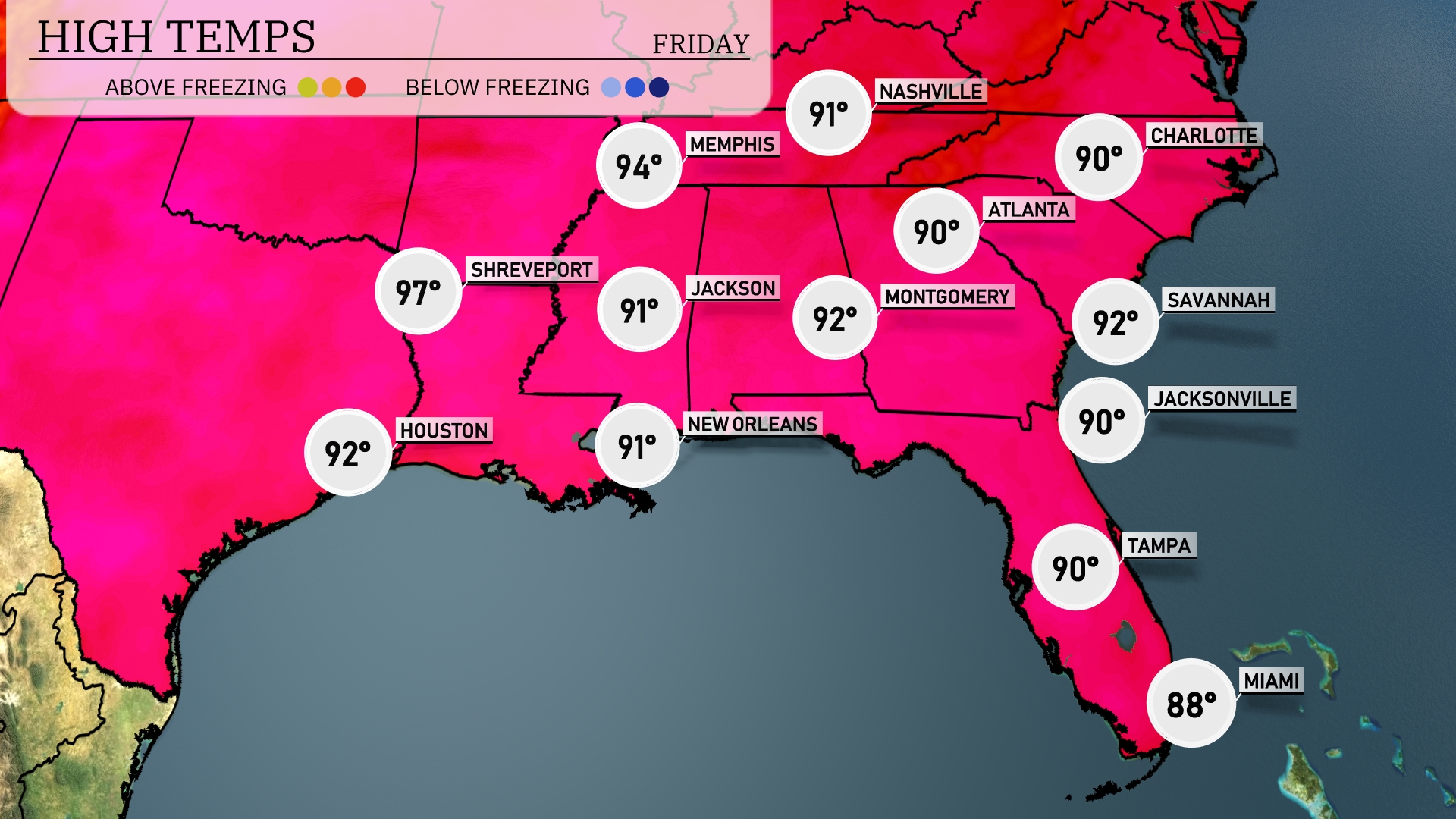
Tomorrow, Shreveport will see a high of 97 degrees, while Houston will reach 92. Memphis is expected to hit 94 degrees, with Jackson not far behind at 91. Most of the Southeast will experience warm temperatures, including Montgomery and Atlanta both forecasted to reach 90 degrees. Miami will be slightly cooler at 88 degrees, indicating a consistent warm pattern across the region.
A cold front pushes eastward, bringing showers and thunderstorms from Houston through New Orleans and into Montgomery by late evening. Expect a line of storms with heavy rain and gusty winds impacting Montgomery and extending towards Jackson. Moving into Thursday morning, the unsettled weather continues to spread across the Southeast, with potential storms developing from Jacksonville to Savannah. Charlotte could experience scattered thunderstorms as the day progresses.
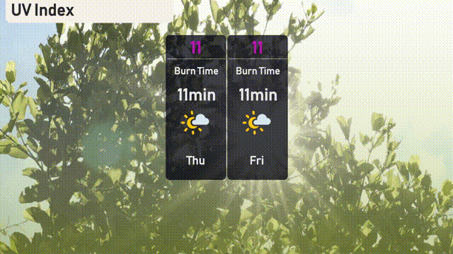
The UV index in Miami for Thursday and Friday is extreme, both days reaching a value of 11, with sun exposure risks that could lead to burns in just 11 minutes.