Catching Rays and Dodging Showers: Miami’s April Weather Forecast
By
Amy Freeze
Dive into a detailed breakdown of Miami’s week-long weather forecast from clear skies to potential storms. Delivered with the precision you seek by Meteorologist Amy Freeze.
Catch the latest weather trends in Miami with Meteorologist Amy Freeze as we cover everything from peaceful mornings to stormy evenings in the Southeast. Stay ahead of the weather!
Miami Afternoon News – 04/09/2025
Meteorologist Amy Freeze here with your Southeast Forecast update. With clear skies and a possibility of showers later in the week, this guide provides all you need to plan each day in Miami. Stay informed and prepared for changes, and make the most of the sun when it shines!
For more updates, read our full blog post: https://amyfreeze.ai/miami-weather-forecast-amy-freeze
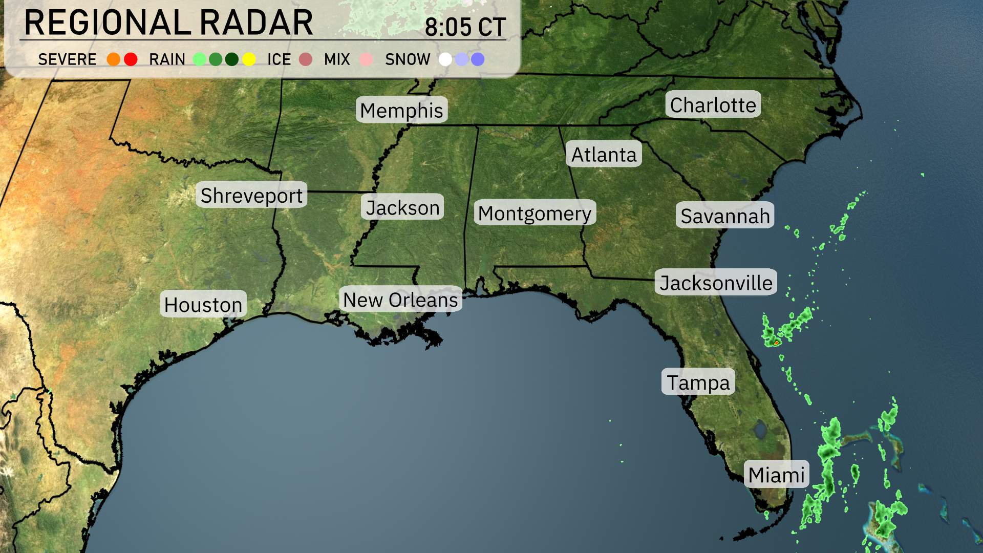
The Southeast region is experiencing mainly clear skies, offering a peaceful morning across the area. We’re seeing scattered showers just off the Atlantic coast to the east of Florida, particularly near Jacksonville and Miami, though land remains mostly dry. As you head north into South Carolina, clear conditions prevail, making it a great day for outdoor activities. Farther inland, cities like Atlanta and Montgomery are basking in sunshine. New Orleans and the western Gulf Coast, including Houston, are enjoying mild weather without any signs of precipitation.
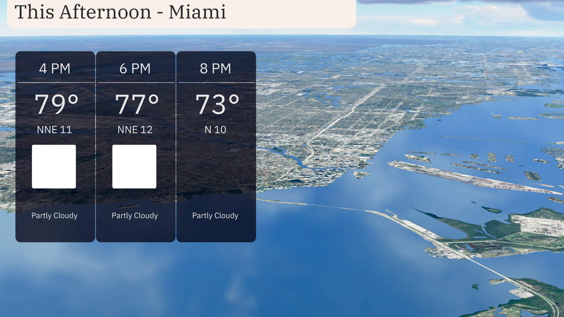
For the afternoon in Miami, temperatures peak at 79 degrees under partly cloudy skies with a wind from the north-northeast at 11 miles per hour. By 6 PM, temperatures gently slide to 77 degrees as the northerly breeze continues at 12 miles per hour. Clouds linger as we move into the evening, contributing to a partly cloudy setting. At 8 PM, plan for 73 degrees with a northerly wind easing slightly to 10 miles per hour.
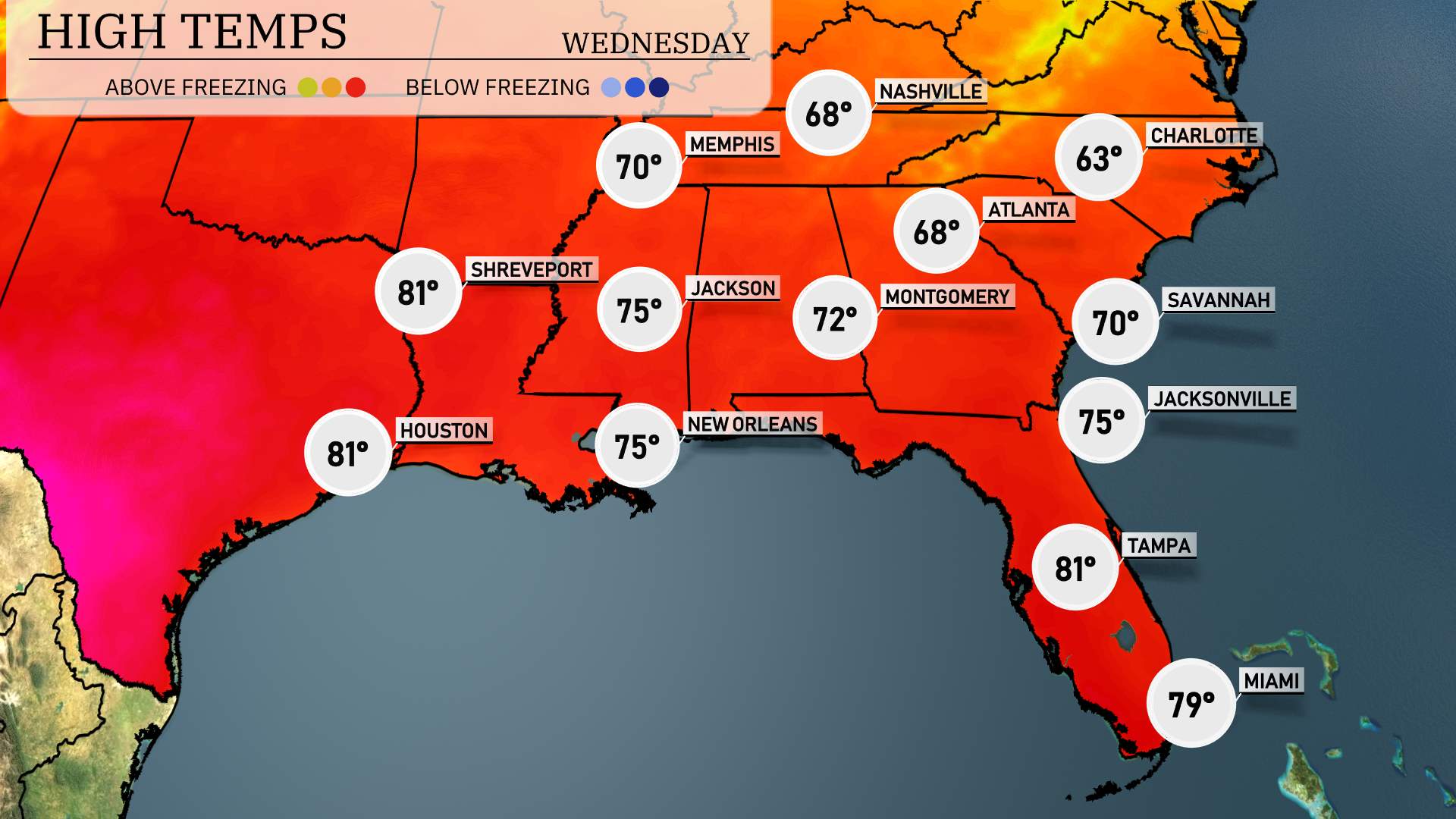
In Shreveport, we’re seeing a warm high of 81 degrees, while Houston shares that warmth, also reaching 81. Over in Jackson, the temperature is a comfortable 75 degrees. Heading to New Orleans, expect a similar pattern with a high of 75.
As we move to the Florida coast, Tampa is basking in sunshine with a high of 81 degrees, while Miami warms slightly more at 79 degrees. In contrast, further up the coast, Jacksonville has a high of 75 degrees, with Savannah hitting 70.
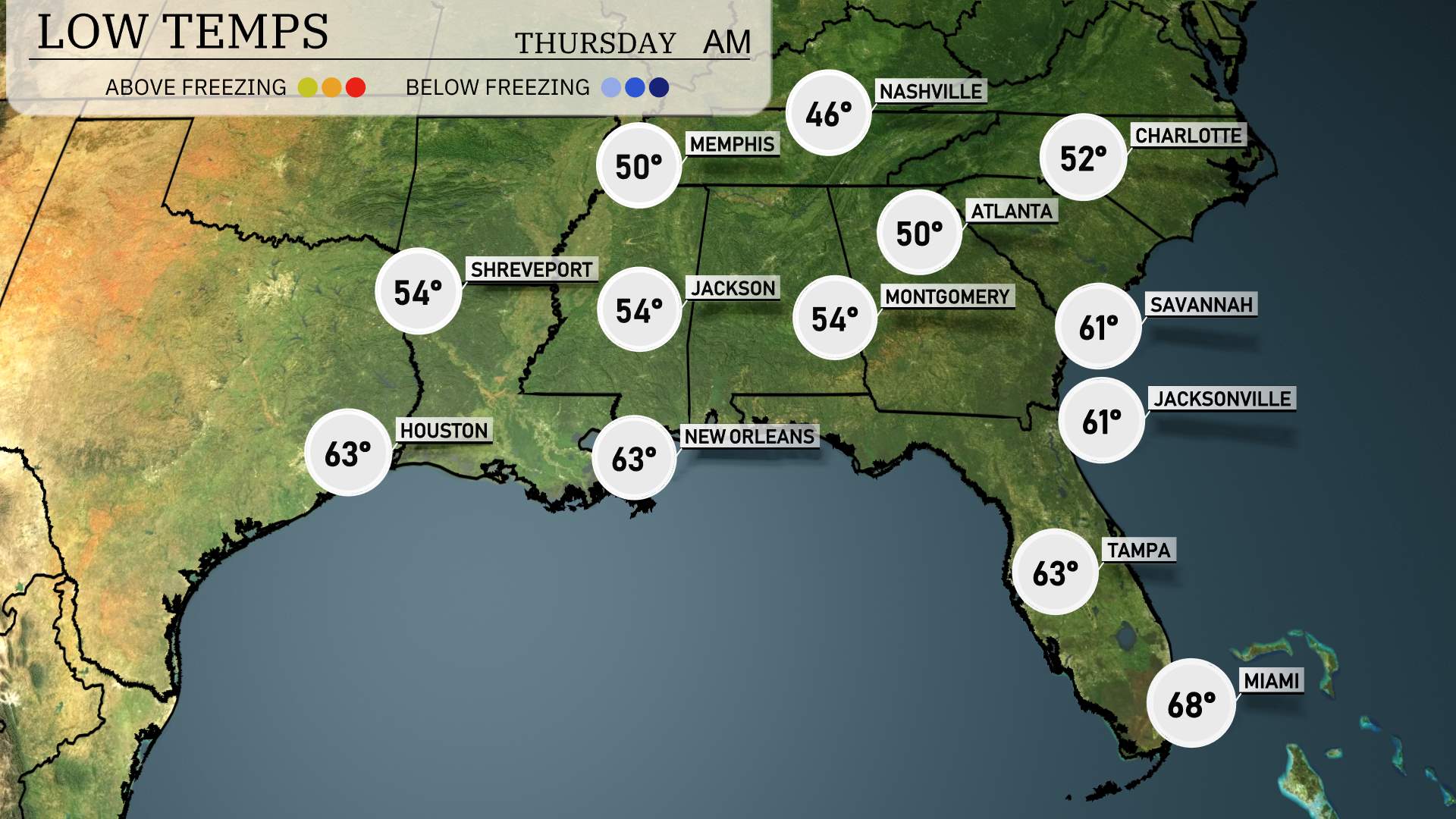
Memphis will drop to 46 degrees, while Nashville cools down to 50. Shreveport is expected to see a low of 54 degrees, and Jackson will also settle at 54. Over in Montgomery, the temperature will dip to 54 degrees. Atlanta will be a bit cooler at 50, while Charlotte sees a low of 52. Further south, Tampa will rest at a mild 63 degrees, and Miami will remain warmer at 68.
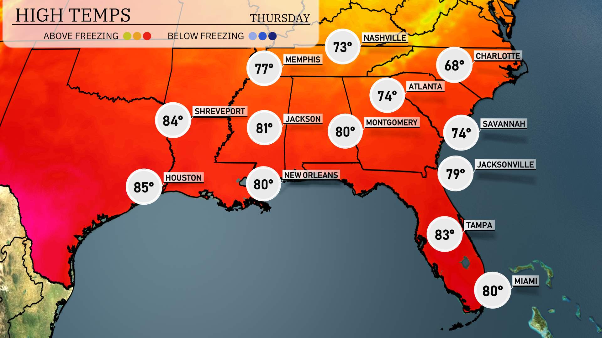
Tomorrow’s temperature forecast for the Southeast shows notable warmth across the region. Key cities are set to experience highs above average for this time of year. Houston tops the charts at a sizzling 85 degrees, while Shreveport reaches 84. Jackson is looking at a pleasant 81 degrees, which is also above the seasonal norm.
Moving east, New Orleans and Montgomery are both expected to hit 80 degrees, signaling a warm day ahead. Atlanta will see a high of 74 degrees, with Savannah slightly warmer at 74 as well. Jacksonville is poised for 79 degrees, while Tampa near the coast anticipates a high of 83 degrees.
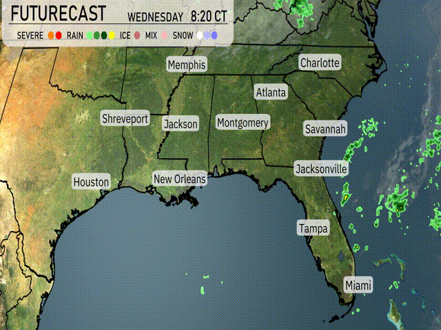
A cold front will push through the Southeast starting Wednesday afternoon, bringing potential thunderstorms from Houston to Shreveport and Jackson. Heavy rain is likely to impact New Orleans overnight into Thursday, with up to two inches possible, increasing flood concerns. By early Thursday, showers will reach Montgomery, Birmingham, and Atlanta, potentially disrupting morning commutes. Expect strong winds accompanying storms through this region. Temperatures will drop behind the front, especially across Mississippi and Alabama, leading to cooler conditions by late Thursday. Jacksonville and Savannah will see storm systems arriving by Thursday evening. Remain alert for severe weather alerts across these areas as the front approaches.
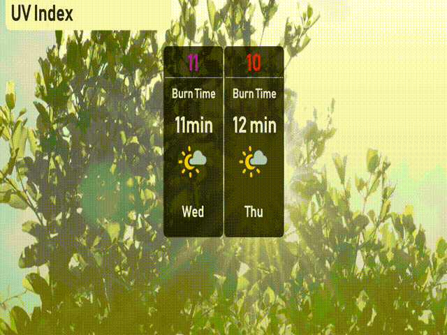
For Miami, Wednesday’s UV index is extremely high at 11, meaning sunburn can occur in just 11 minutes of exposure. Thursday won’t be much different, with a UV index of 10 and a burn time of 12 minutes.