Navigating the Skies of Miami: A Week of Sun, Showers, and Surprises
By
Amy Freeze
Join Amy Freeze as she breaks down the dynamic weather patterns over Miami this week—from stunning clear skies to unexpected rainy twists!
Amy Freeze brings you the latest weather updates for Miami and the Southeast. From sunny days to unexpected showers—know what to expect and plan your week accordingly!
Meteorologist Amy Freeze here with your complete guide to this week’s weather in Miami. Zooming in from clear sunny skies to sudden showers spiraling along the coast, we have it all covered in our comprehensive forecast. Keep an eye on our daily updates for the latest changes and prepare for the week with insights on temperatures, potential storms, and our detailed seven-day weather outlook. Stay informed and enjoy the diverse weather dynamics of Miami!
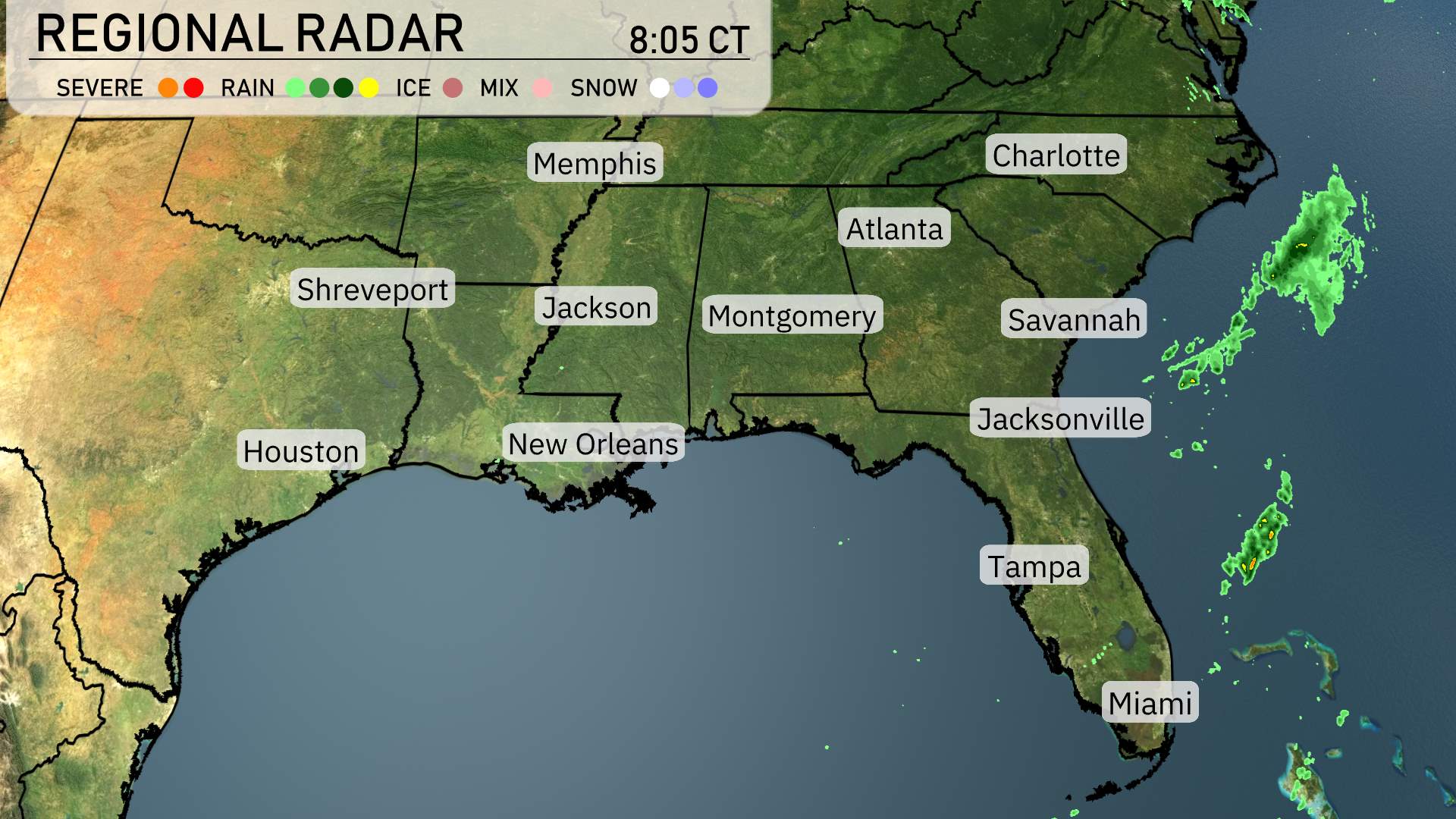
The Southeastern radar reveals an engaging mix of weather conditions today. Rain is moving inland over southern Florida, particularly affecting areas around Miami and Tampa with showers spiraling along the coast. Northern Florida, including Jacksonville, remains mostly clear, enjoying a break from any significant precipitation.
Across Georgia and the Carolinas, skies are clear, providing pleasant outdoor conditions. Parts of Alabama, near Montgomery, are also free from rain with scattered clouds that are not generating any significant weather changes.
In Texas and surrounding areas, places like Houston are currently experiencing clear skies without signs of storms or rain. As we look farther north, regions like Memphis and Shreveport show calm conditions on the radar.
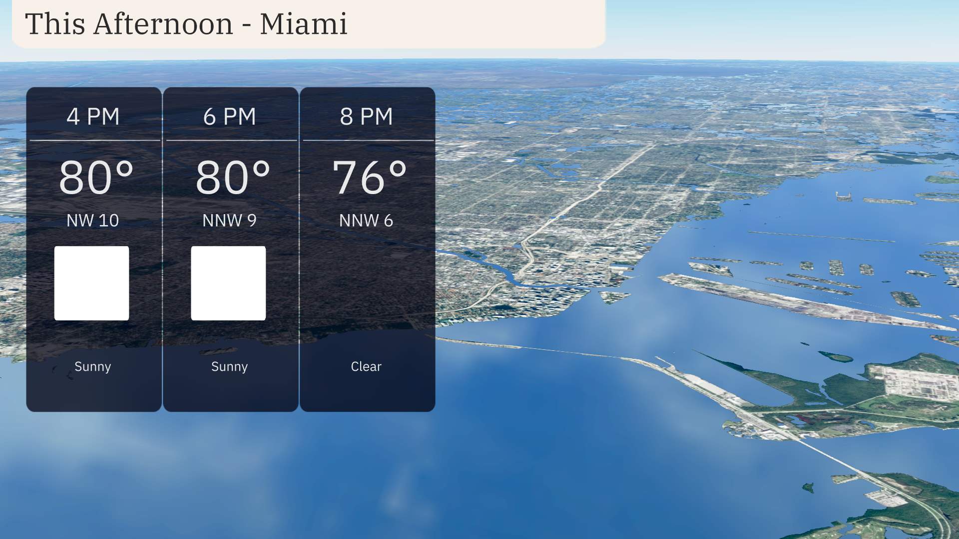
Afternoon conditions in Miami feature temperatures holding steady around 80 degrees with a north-northwest wind at 10 miles per hour, decreasing slightly as the afternoon progresses. Expect sunny skies to remain dominant, providing a bright and clear atmosphere. As the day transitions toward evening, temperatures begin to dip to 76 degrees by 8 PM, accompanied by a gentle northwest breeze at 6 miles per hour.
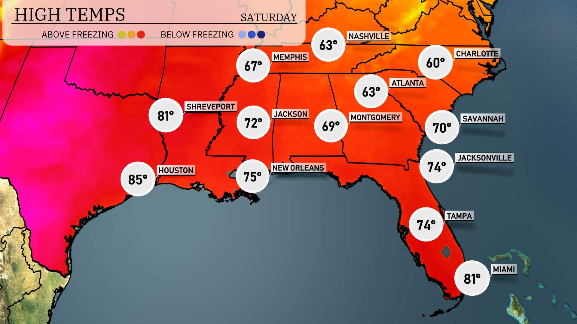
Starting with Louisiana, Shreveport is feeling quite warm with a high of 81 degrees, while New Orleans reaches 75. Heading east to Mississippi, Jackson sees a high of 72 degrees.
In Alabama, Montgomery is a bit cooler at 69 degrees. Over in Georgia, Atlanta is sitting at 63 degrees, with Savannah slightly warmer at 70.
Moving to Florida, Jacksonville hits 74 degrees, and Tampa is right there with a high of 74 as well. Down in Miami, temperatures climb to a comfortable 81 degrees, contrasting with the cooler air in the northern parts of the region.
Memphis will see a low of 33 degrees, plunging into the freezing range. Nashville isn’t far behind at 35. Over in Shreveport, temperatures will dip to 57 degrees, while Jackson will cool down to 51. Montgomery is forecasting a low of 50 degrees. Atlanta is expected to see a low of 30, making it one of the colder spots tonight. Meanwhile, Tampa will remain milder with a low of 57, and Miami rounds out the reports at a warm 67 degrees.
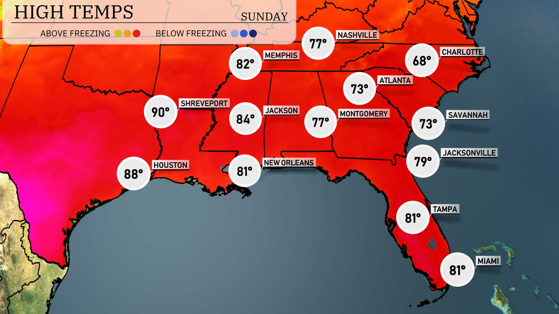
Tomorrow’s high temperatures in the Southeast will be notably warm, with several cities experiencing readings significantly above average for April.
In Shreveport, Louisiana, expect a high of 90 degrees, which is well above the seasonal norm. Houston will see a warm afternoon reaching 88 degrees. Jackson, Mississippi, isn’t far behind with a high of 84 degrees.
In New Orleans, anticipate a pleasant 81 degrees, while Montgomery, Alabama, should get to a comfortable 77 degrees. Atlanta will experience highs around 73 degrees, still reflecting the warm trend.
Tampa and Miami will both hit a high of 81 degrees, providing a balmy day for residents there. Meanwhile, Jacksonville, Florida, will warm up to 79 degrees, adding to the overall warm pattern in the region.
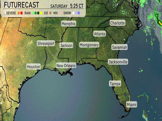
On the futurecast for the Southeast, a developing storm system will bring active weather conditions. Thunderstorms are forecast to track northeast from Texas towards Louisiana, Mississippi, and Alabama late tonight into early Sunday. With these storms, there’s a potential for heavy rain and gusty winds, especially near the Gulf Coast. A frontal boundary moves closer to Jacksonville and Savannah by late afternoon Sunday, increasing the chance of showers. Be on alert for potential severe weather including strong thunderstorms in parts of eastern Alabama and western Georgia through Sunday afternoon.
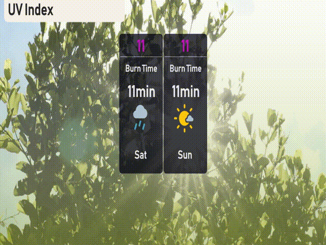
The UV index in Miami is at its peak with an extreme level of 11 for both Saturday and Sunday. With this strong sunlight, burn times can occur in as little as 11 minutes