Sunny Spells and Stormy Skies: Navigating Miami’s Weather Wonders
By
Amy Freeze
Explore the fluctuating weather patterns of Miami and the Southeast with meteorologist Amy Freeze. From soothing sunny days to severe storm warnings, understand what's happening outside your door.
Catch up on Miami’s latest weather trends from sunny afternoons to looming storms. Meteorologist Amy Freeze breaks down the Southeast’s weather, ensuring you’re fully prepared!
Greetings from the heart of changing weathers! This is Amy Freeze taking you through the intricate patterns of Miami’s climate. This blog offers a detailed look into our current weather with insights into how temperatures shift and storms approach. We explore each element—from soothing sunny skies over Miami to the dramatic shift towards gusty storms sweeping from Jackson to Montgomery. I break down predictions by regions, discuss the implications for your daily plans, and provide expert tips for staying safe and enjoying the weather!
On the Regional Radar, we’re seeing quite an active weather setup across the Southeast. A significant line of severe storms is making its way from Jackson towards Montgomery, bringing lightning and gusty winds. Meanwhile, areas like Shreveport and Memphis are experiencing persistent rain showers that are tracking northeast.
The conditions become more intense as we move further east, with Atlanta currently under a band of heavy rain. If you’re in Charlotte, get ready, as these rain showers are slowly making their way in your direction.
Down south, New Orleans is seeing some scattered rain, with the occasional heavier burst; however, the conditions are clearer towards Houston. Coastal cities like Savannah and Charleston are having some reprieve with scattered clouds, but Jacksonville is shaking off some showers as they move offshore.
In Northern Florida and around Tampa, skies are starting to clear, offering a more tranquil atmosphere. Keep an umbrella handy if you’re planning to head out, especially if you’re near the areas impacted currently, as this setup keeps shifting eastward.
This afternoon in Miami, temperatures hover around 82 degrees at 3 PM, with partly cloudy skies creating a pleasant atmosphere. As we move closer to 5 PM, expect mostly sunny conditions with temperatures slightly decreasing to 81 degrees. Winds are blowing from the southeast at 14 miles per hour, gradually easing to 12 miles per hour later in the afternoon. By 7 PM, conditions shift to mostly clear skies, as temperatures further decrease to 79 degrees with a gentler southeast breeze at 9 miles per hour. Enjoy the beautiful Miami weather!
Starting off in New Orleans, we’re looking at a warm day with a high of 81 degrees. Jackson is slightly cooler at 68 degrees, while Birmingham heats up to 77. Over in Montgomery, temperatures rise to 75.
Moving east, Atlanta sees a pleasant high of 82 degrees, and in Savannah, we ramp it up to 84. In Jacksonville, brace yourselves for a hot one as we hit 90 degrees!
Looking down to Florida, Tampa stands out with a high of 88 degrees. Meanwhile, Miami will enjoy a comfortable 82 degrees.
Tonight in the Southeast, temperatures will dip significantly, bringing a chilly start to many areas. In Memphis, expect a low of 34 degrees, while Nashville will be slightly colder at 33 degrees. Shreveport is forecasting a low of 41, and Jackson will match that with 41 degrees as well. Montgomery will see a low of 43 degrees, and in Atlanta, temperatures are expected to drop to 43 degrees as well. Moving further south, New Orleans should stay a bit warmer at 50 degrees. Coastal cities like Jacksonville will experience 55 degrees, while Savannah is forecasting 52 degrees.
Expect a warm-up across the Southeast tomorrow, with significant above-average temperatures in many areas. Atlanta is forecasted to reach a high of 70 degrees, while temperatures rise to 66 in Shreveport. New Orleans will see a pleasant 61 degrees.
In contrast, Jacksonville is set to sizzle with a high of 90 degrees, possibly making it one of the hottest spots in the region. Savannah won’t be far behind, hitting 82 degrees. Tampa is also looking warm at 88 degrees. Miami is expected to hit 84 degrees, contributing to the overall warm trend.
This surge in temperatures is influenced by a ridge of high pressure, enabling warmer air to spread across the region. As a result, residents should prepare for milder conditions than what is typically expected this time of year.
A cold front is set to impact the Southeast tonight, ushering in a line of strong thunderstorms from Mississippi to Georgia. Expect intense rainfall and gusty winds, with possible severe weather risks tomorrow, especially along the Gulf Coast. Heavy downpours bring the threat of localized flooding from New Orleans through Atlanta. By midday tomorrow, showers extend farther east to Jacksonville and Savannah. Cooler air follows the front, bringing a more mild pattern into midweek. Stay alert for weather updates over the next 48 hours.
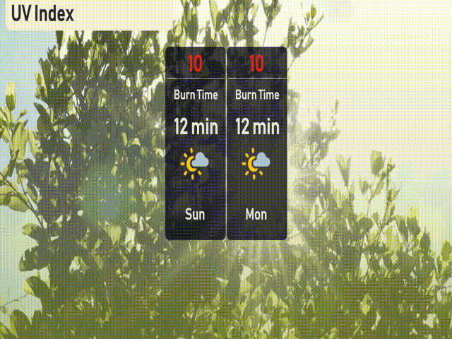
The UV index in Miami is soaring to a very high 10 for both Sunday and Monday, with a quick burn time of just 12 minutes.