Sunny Starts and Thunderous Evenings: Your Southeast Weather Guide
By
Amy Freeze
Explore the nuances of Miami’s dynamic weather, from delightful sunny mornings to the potential thunderstorms that could reshape your day. Our comprehensive guide dives into the weekly forecast and what these changes mean for you.
Get ready for a week filled with weather surprises in Miami and across the Southeast! From sunny skies to sudden showers, our latest blog post has all the details you need to stay prepared.
This week in Miami, expect a blend of radiant sunny mornings and potential stormy afternoons. We’re covering each day’s forecast, analyzing patterns, and preparing you for what might come your way. Whether you’re planning outdoor activities or need to navigate a storm, we’ve got your back. Find out more about the upcoming weather changes and how they could affect your week in our detailed blog at https://amyfreeze.ai/.
The Southeast region is currently enjoying mostly clear skies, with some notable exceptions. Light rain showers are moving offshore into the Atlantic from Savannah to Jacksonville, while Miami experiences scattered showers. Inland areas like Memphis and Atlanta remain dry under partly cloudy conditions. A few showers are also seen along the Gulf, just south of New Orleans.
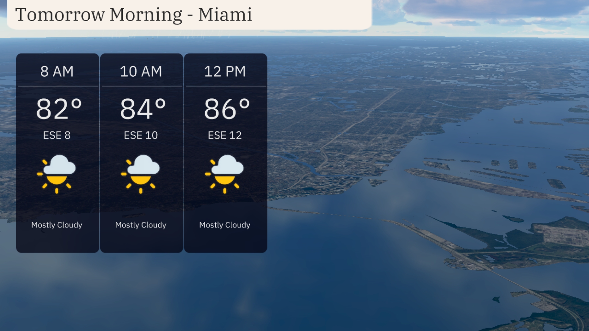
Miami starts the morning mostly cloudy with temps at 82 degrees at 8 AM. By 10 AM, expect slight warming to 84 degrees with an east-southeast breeze at 10 mph. Clouds remain into mid-morning, as temperatures rise further to 86 degrees by noon with winds of 12 mph.
Tomorrow in the Southeast, Shreveport is expected to hit a blistering 96 degrees, while Houston follows closely with a high of 92. Memphis will also see a warm day, reaching 95 degrees. Atlanta is shaping up to be quite warm at 93 degrees, and Montgomery hits 91. Miami remains on the milder side with a high of 87 degrees.
Expect an active weather day across the Southeast as a frontal boundary approaches from the west. Scattered thunderstorms and heavy downpours are set to move through Alabama, Georgia, and the Florida Panhandle late tomorrow morning, with the potential for localized flooding. Keep an eye on the skies in Montgomery and Atlanta, as strong gusty winds could accompany these storms. By afternoon, showers extend into the Carolinas, with temperatures dropping slightly behind the front. Areas from Jacksonville to Savannah should prepare for a wet commute with rainfall continuing into the evening hours.
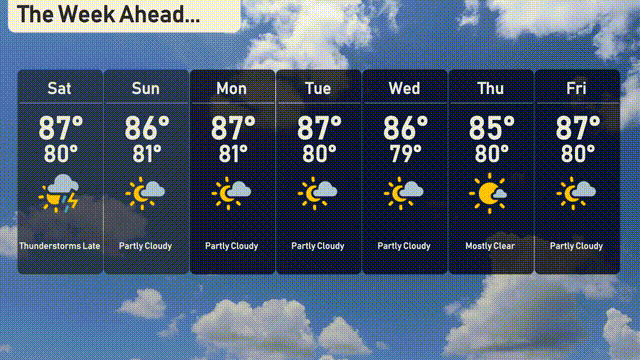
The UV index in Miami on Saturday will be extreme, reaching a level of 11, with a burn time of just 11 minutes in direct sunlight. On Sunday, it’s slightly lower but still very high at 9, and a burn time of 15 minutes is expected.
Saturday: Thunderstorms late in the day, with a high reaching 87 degrees and a low of 80 degrees.
Sunday: Partly cloudy skies with a daytime high of 86 degrees and cooling to 81 degrees at night.
Monday: Expect partly cloudy conditions with temperatures peaking at 87 degrees and dipping to 81 degrees.
Tuesday: Another partly cloudy day with highs around 87 degrees and lows near 80 degrees.
Wednesday: Sunny and pleasant with a high of 86 degrees and a low of 79 degrees.
Thursday: Mostly clear skies, bringing a high of 85 degrees and a low of 80 degrees.
Friday: Enjoy partly cloudy conditions with temperatures climbing to 87 degrees and an overnight low of 80 degrees.