Sunshine and Storms: A Glimpse Into Southeast’s Varied Weather
By
Amy Freeze
Tomorrow's forecast in Miami shows partly cloudy skies with a breeze, while severe storms prepare to hit New Orleans. Read on for your detailed weather guide from Miami to Memphis.
Navigate your day with our detailed weather update for Miami and the Southeast! From clear skies in Miami to looming storms in New Orleans. Full details on our blog!
This week in weather brings Miami a taste of partly cloudy mornings while severe weather threatens to reshuffle plans across the Southeast. With temperature peaks and vital UV index warnings, our comprehensive guide ensures you’re fully prepared whatever the weather. Discover how each major city in the Southeast is expected to fare in the coming days, and how to best prepare for Miami’s extreme sun exposure.
Severe thunderstorms are developing around New Orleans, pushing northeast toward Jackson while showers extend further into Mississippi. The radar highlights some rain activity reaching southeast Alabama, with areas such as Montgomery expecting on-and-off showers. Cloud cover is increasing over the central and northern parts of the Southeast, including cities like Atlanta and Charlotte, suggesting a transition to wetter conditions as systems move in.
Temperatures in Miami for tomorrow morning start at 83 degrees at 8 AM, reaching 87 degrees by noon, with partly cloudy skies. Expect a light southeast wind around 9 to 13 miles per hour throughout the morning.
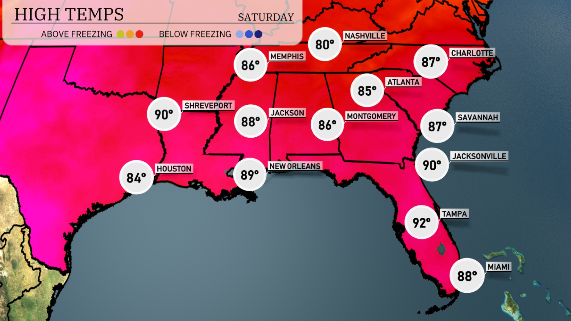
Tomorrow in Atlanta, expect a high of 85 degrees, slightly above average for this time of year. Memphis will reach 86 degrees, while Nashville sees a pleasant high of 80 degrees. Down in New Orleans, temperatures are going up to 89 degrees, and Houston will enjoy a warm 84 degrees. Jacksonville will hit 90 degrees, and farther south, Tampa is projected to reach a sizzling 92 degrees.
A cold front is pushing through the Southeast, bringing widespread thunderstorms that could be severe, especially from Jackson to Atlanta by early Thursday. Expect heavy rain across Alabama and the Florida Panhandle, with potential for localized flooding. Temperatures will drop after the front passes, bringing much cooler air into Friday. Lingering showers can be expected in New Orleans and Savannah through Thursday evening.
Miami’s UV index is expected to reach an extreme value of 11 on both Friday and Saturday. With burn times of just 11 minutes in direct sunlight, it’s crucial to take precautions.
For the 7-day forecast in Miami:
Friday: Partly cloudy skies with a warm high of 87 degrees and a low of 81 degrees.
Saturday: Similar conditions with highs reaching 87 degrees and lows at 80 degrees.
Sunday: Expect partly cloudy weather again, with the temperature peaking at 87 degrees and dipping to 80 degrees overnight.
Monday: A mostly clear day with temperatures reaching up to 87 degrees and a low of 80 degrees.
Tuesday: Partly sunny skies dominate, with a high of 87 degrees and lows around 81 degrees.
Wednesday: Slightly warmer with an expected high of 88 degrees and a low of 81 degrees under partly sunny skies.
Thursday: Partly cloudy conditions return with temperatures around 87 degrees and a low of 80 degrees.