Weather Whirlwind in Miami: Sunny Days and Thunderous Nights
By
Amy Freeze
Explore the swings in Miami's weather from sunny days to stormy evenings. Stay updated with our detailed Southeast forecast.
This week in Miami sees a mix of weather from clear skies to potential thunderstorms. Be prepared as we transition from warm sunny days to possible stormy nights.
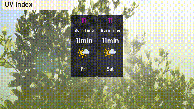
Miami and the Southeast are on a weather rollercoaster this week, featuring partly cloudy skies, high temperatures, and incoming storms. As Miami enjoys relatively comfortable conditions, a cold front is set to bring thunderstorms and potential flooding in area. With the UV index hitting 11, it’s crucial to protect yourself from direct sunlight.
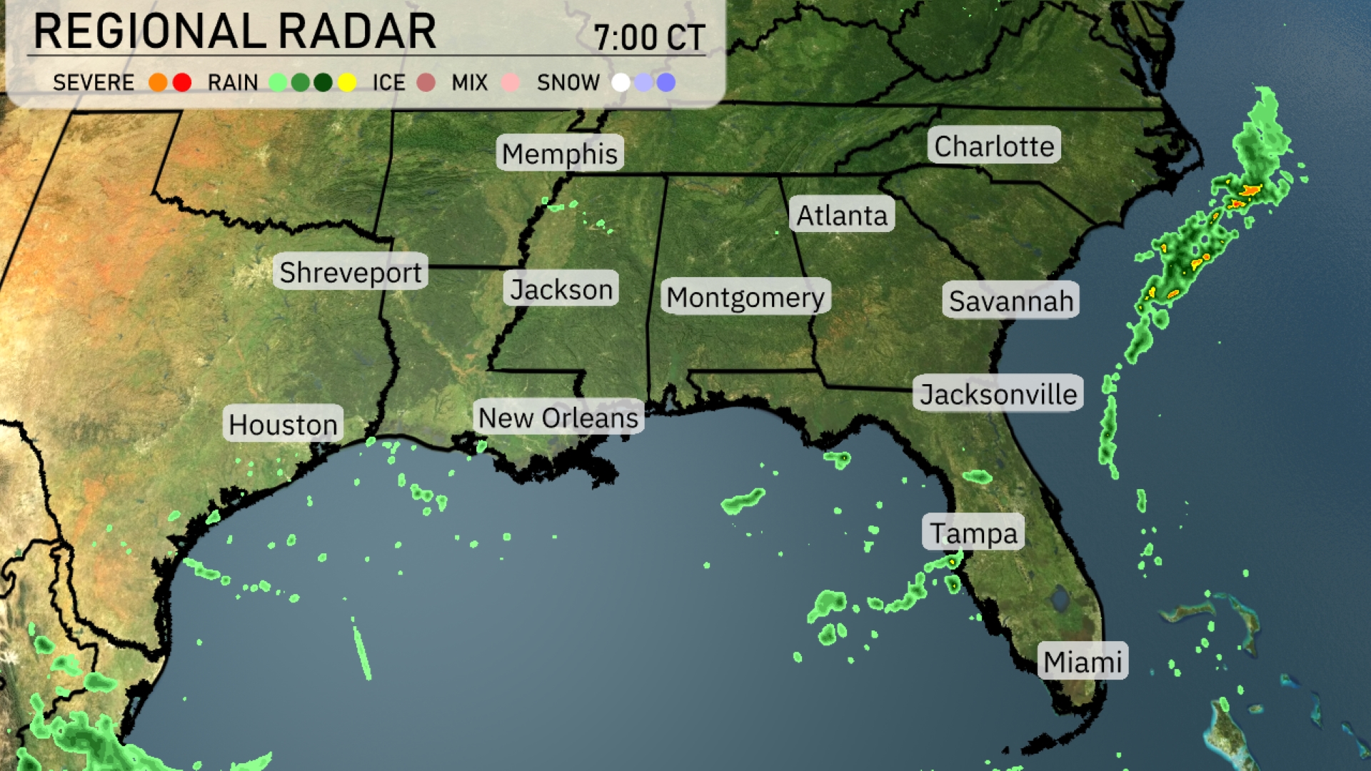
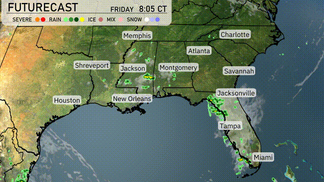
Showers are moving off the west coast of Florida near Tampa and Miami, gently clearing as they head out to sea. A few spotty rain showers can be seen along the Gulf Coast near New Orleans and Houston. Meanwhile, the rest of the Southeast, including cities like Atlanta, Charlotte, and Jackson, enjoys clear skies with expanding sunshine.
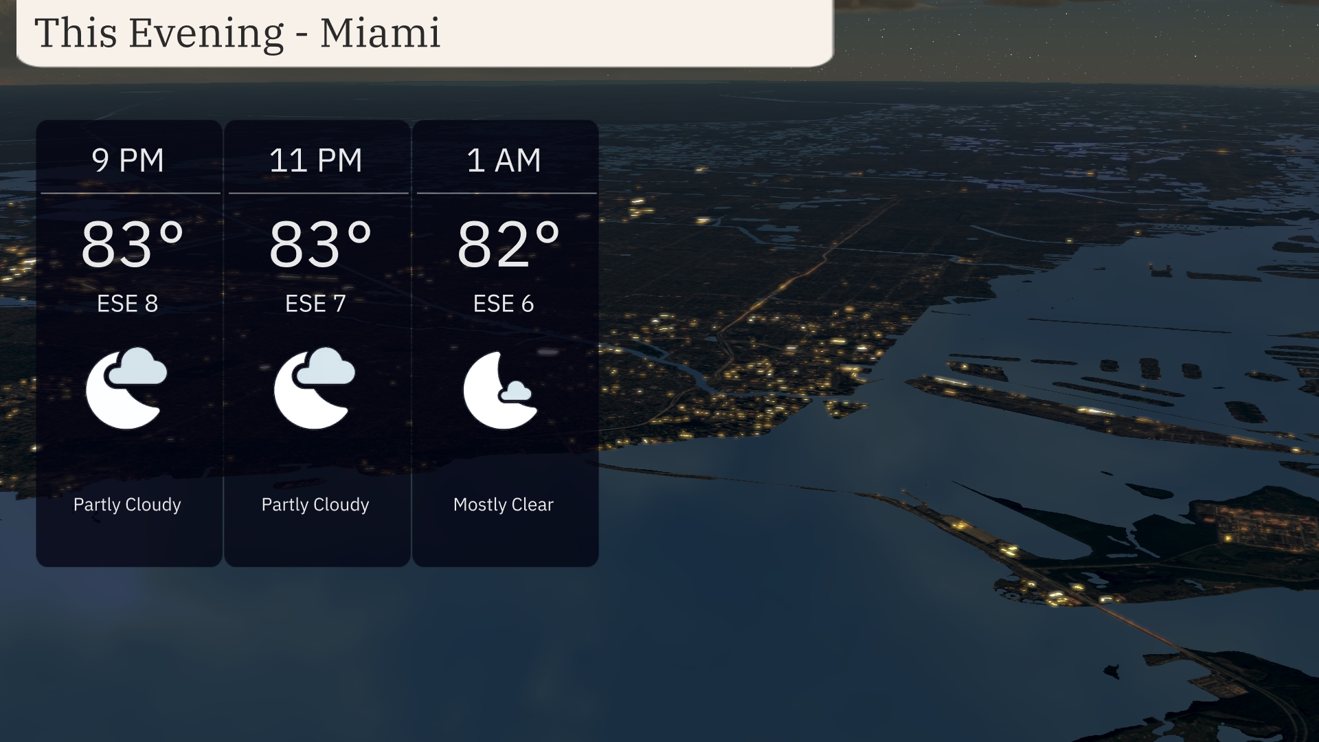
This evening in Miami, anticipate partly cloudy skies transitioning to mostly clear conditions by 1 AM. Temperatures will hold steady at 83 degrees around 9 PM and 11 PM, slightly cooling to 82 degrees at 1 AM. An easterly breeze will persist with winds from the southeast at 8 to 7 miles per hour through the evening.
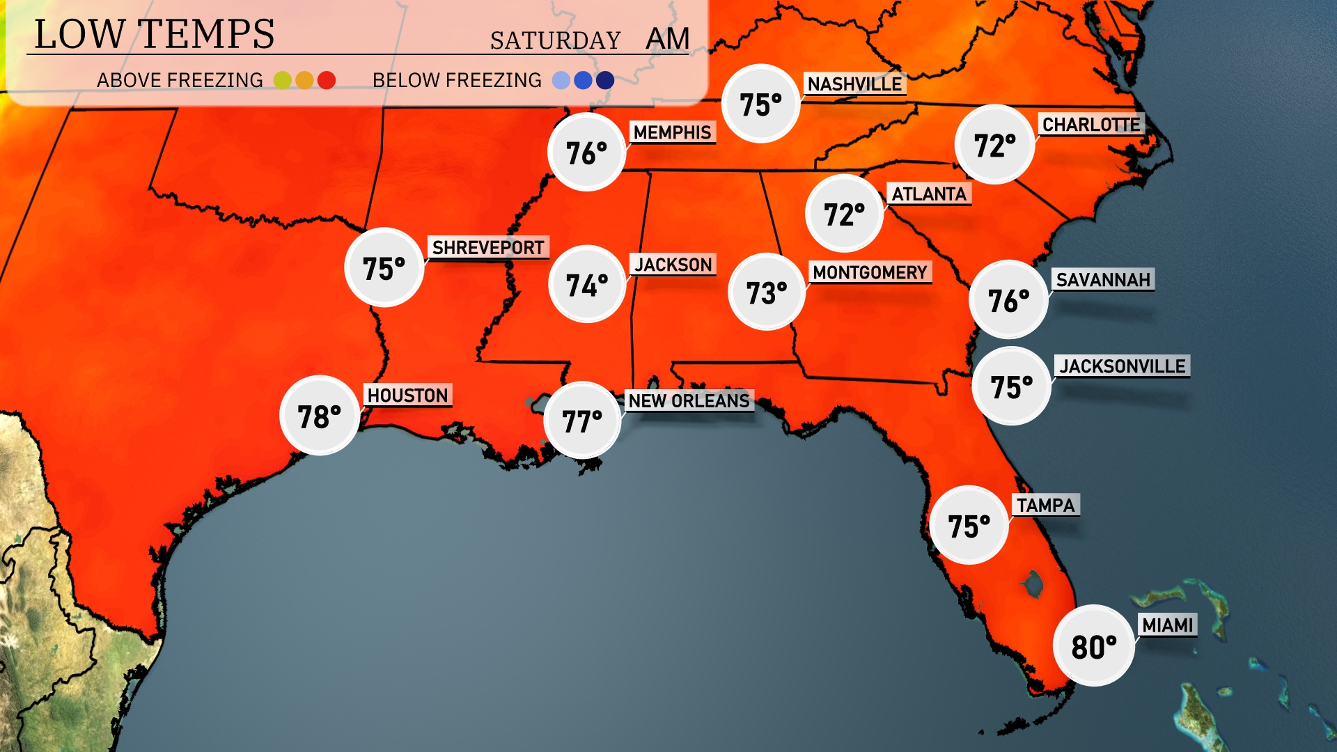
Tonight, temperatures in the Southeast will drop into the 70s, with Memphis hitting a low of 75 degrees. Jackson will stay slightly cooler at 74 degrees, while Shreveport is expected to reach 75. In Alabama, Montgomery will see a low of 73 degrees, and Atlanta will also cool down to 72 degrees. Miami remains warm, with a mild 80 degrees expected overnight.
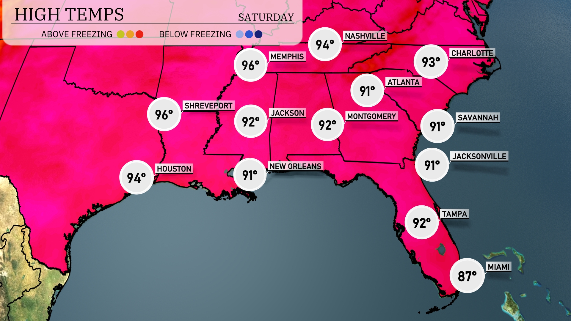
Tomorrow in the Southeast, expect a scorching day with temperatures rising significantly. Memphis is forecasted to reach 96 degrees, while Nashville will hit a high of 94. Shreveport should see a warm 96 degrees and New Orleans will be slightly cooler at 91. In Florida, Jacksonville and Tampa will both see highs of 91 and 92 degrees, respectively, while Miami warms up to 87.
In the Southeast, a cold front is set to usher in storms on Friday night, particularly around Jackson, Montgomery, and into the Florida Panhandle. Expect scattered thunderstorms progressing eastward toward Atlanta and Savannah. With this front, localized heavy rain is possible, leading to potential flooding in prone areas. Temperatures will drop slightly behind the front, providing some relief from the recent heat.
The UV index in Miami will reach a very high level of 11 on Friday and Saturday, with a burn time of around 11 minutes in direct sunlight. With such intense UV exposure, it’s crucial to use high SPF sunscreen and wear protective clothing.
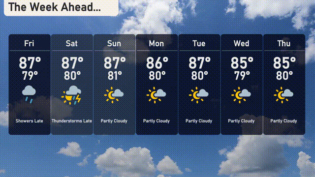
For the 7-day forecast in Miami:
Friday: Expect a high of 87 degrees with evening showers and a low of 79 degrees.
Saturday: Thunderstorms roll in late with a high of 87 degrees and a low of 80 degrees.
Sunday: Partly sunny skies with a high reaching 87 degrees and a low of 81 degrees.
Monday: A mix of sun and clouds, staying warm with a high of 86 degrees and a low of 80 degrees.
Tuesday: Partly cloudy skies continue with temperatures peaking at 87 degrees and dipping to 80 degrees at night.
Wednesday: More clouds in the sky, with a high of 85 degrees and a low around 79 degrees.
Thursday: Partly cloudy conditions, maintaining a warm high of 85 degrees.