From Balmy Breezes to Boisterous Storms: Miami’s Dynamic Weather This Week
By
Amy Freeze
As the sun sets on Miami, the weather is anything but predictable. From clear skies to approaching storms, stay updated with our comprehensive forecast.
This week in Miami, expect a variety from clear skies to possible storm threats. Here’s your timely Southeast weather forecast to keep you prepared.
Miami is set for another eventful weather week. Starting with clear skies tonight but don’t be fooled, as we’re tracking storms near New Orleans heading our way. Temperatures stay warm, cooling slightly at night, with storm risks escalating by tomorrow. Ensure to watch out for those UV levels before heading out!
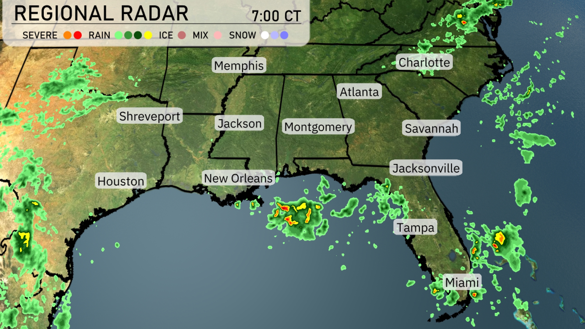
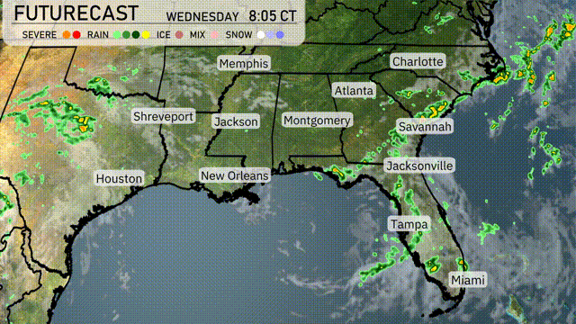
A cluster of storms is presently situated off the coast near New Orleans, bringing intense rain showers. In the Florida Peninsula, isolated showers are affecting Tampa’s vicinity with potential development towards Miami. Cloud cover is advancing over Atlanta and the Carolinas, indicating incoming precipitation. The remnants of a front are bringing scattered rain showers over Houston and pushing eastward.
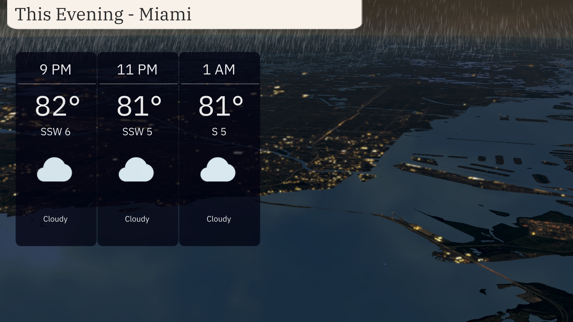
This evening in Miami, anticipate cloudy skies with temperatures maintaining a consistent 82 to 81 degrees from 9 PM to early morning. Winds will be gentle from the south-southwest at 6 to 5 miles per hour, shifting to south at 5 miles per hour by 1 AM.
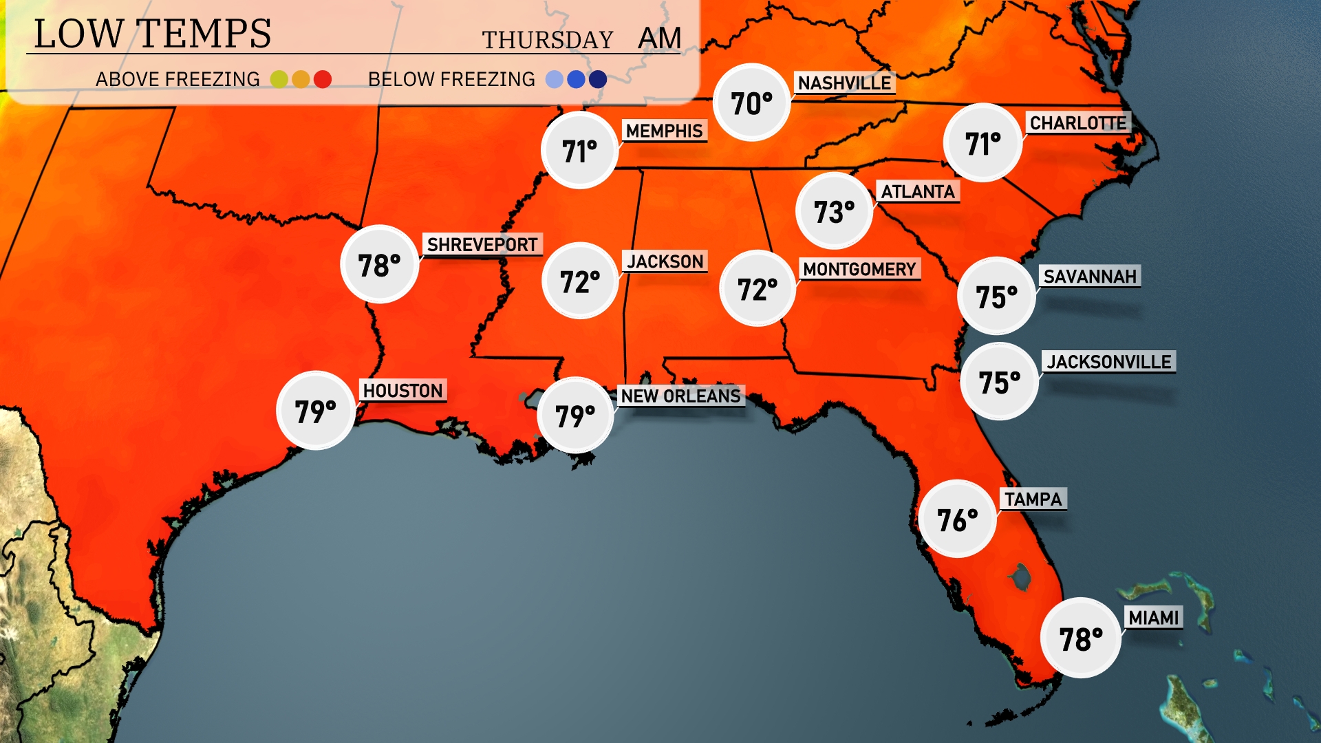
Tonight, Memphis will cool down to 71 degrees. Nashville is expected to see a low of 70 degrees, while Jackson will rest at 72 degrees. Further south, New Orleans will be notably warmer at 79 degrees, and Houston will not dip below 79 either.
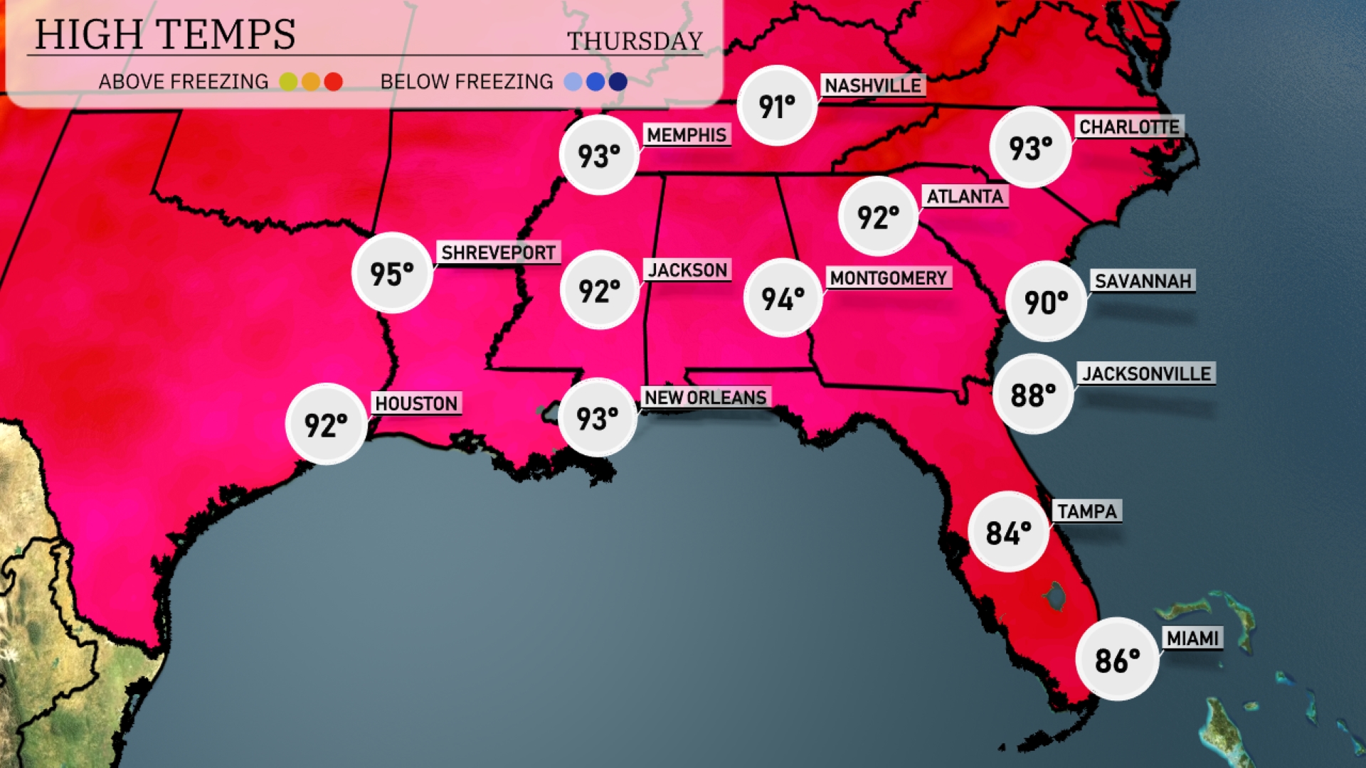
Tomorrow, temperatures are heating up across the Southeast. Shreveport leads the pack with a high of 95 degrees, while New Orleans and Jackson are both looking at 93 degrees. Atlanta is set to reach 92 degrees, slightly above average for this time of year. Farther east, Savannah will warm up to 90 degrees and Jacksonville will see a high of 88. Miami should be comfortable at 86 degrees, reflecting the typical summer warmth in the region.
A band of thunderstorms is forecasted to move across the Southeast region tomorrow, with the potential for severe weather primarily over northern Florida and coastal Georgia. Expect heavy rainfall and possibly damaging winds, particularly in areas from Jacksonville to Savannah. By late afternoon, the system progresses further into the Carolinas, potentially impacting Charlotte with rain showers. New Orleans and Atlanta should brace for scattered storms, which may affect the afternoon commute. Cool and dry conditions are anticipated to follow this system, leading into the weekend.
Miami’s UV index on Wednesday will be extreme at 10, with sunburn possible in just 12 minutes. Thursday brings slight relief with a very high index of 8, resulting in a burn time of 17 minutes.
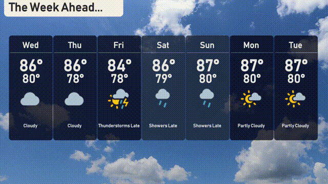
For the 7-day forecast in Miami:
Wednesday: Cloudy with a high of 86 degrees and a low of 80 degrees.
Thursday: Continuing cloudy skies, with the temperature reaching 86 degrees and a low of 78 degrees.
Friday: Keep an umbrella handy—thunderstorms are expected late in the day, with a high of 84 degrees and a low of 78 degrees.
Saturday: Afternoon showers with a high of 86 degrees and dipping to 79 degrees at night.
Sunday: More showers late in the day, with temperatures reaching up to 87 degrees for the high and 80 degrees for the low.
Monday: Partly cloudy skies providing a bit more sunshine, with a high of 87 degrees and a low of 80 degrees.
Tuesday: Partly cloudy with consistent temperatures, reaching a high of 87 degrees and a low of 80 degrees.