Miami Weather Update: From Scorching Sun to Stormy Skies
By
Amy Freeze
Catch up on Miami's latest weather trends with Amy Freeze. From bright sunny days to potential storm warnings, here's everything you need to know to plan your week effectively.
This week in Miami, expect a mix of sun and storms. Enjoy sunny days with highs up to 84°F but stay alert for potential thunderstorms, especially towards the week’s end. Detailed forecast available on our blog.
Amy Freeze brings you the latest weather outlook for Miami. With a week featuring partly cloudy skies, high temperatures, and the possibility of stormy evenings, knowing what to expect can greatly affect your plans and safety. Highs of 84°F will make for pleasant days, while evenings could bring thunderstorms with potential flash flooding. Stay updated with our comprehensive weather forecast at https://amyfreeze.ai/, and never be caught off guard by Miami weather again!
Rain showers are sweeping across the Gulf Coast, from Houston to New Orleans, with some heavy pockets of rain moving inland. A cluster of thunderstorms is located over Charlotte, North Carolina, producing heavy rainfall and occasional lightning. Light rain is also currently falling over Jackson, Mississippi, and creeping toward Montgomery, Alabama. Savannah, Georgia, is still under dry conditions but may see some showers moving in later. Parts of South Florida, including Miami and Tampa, remain clear under fair skies for now.
Miami’s afternoon is looking bright and warm with temperatures peaking at 84 degrees and a clear, sunny sky. Expect a southeast wind at 11 miles per hour, bringing a gentle breeze to the mix. By 6 PM, temperatures will slightly dip to 83 degrees, accompanied by partial clouds. Later in the evening, temperatures drop to a pleasant 80 degrees with winds shifting to the south-southeast at 9 miles per hour, maintaining partly cloudy conditions.
Today’s high temperatures across the Southeast are quite toasty. Atlanta will see a high of 80 degrees, while Montgomery reaches 83. Heading south, Jacksonville is feeling the warmth with a high of 89, matching Tampa’s temperature of 89 as well. Farther east, Savannah is slightly cooler with a high of 86 degrees. In contrast, New Orleans only reaches 73, making it one of the cooler spots in the region today.
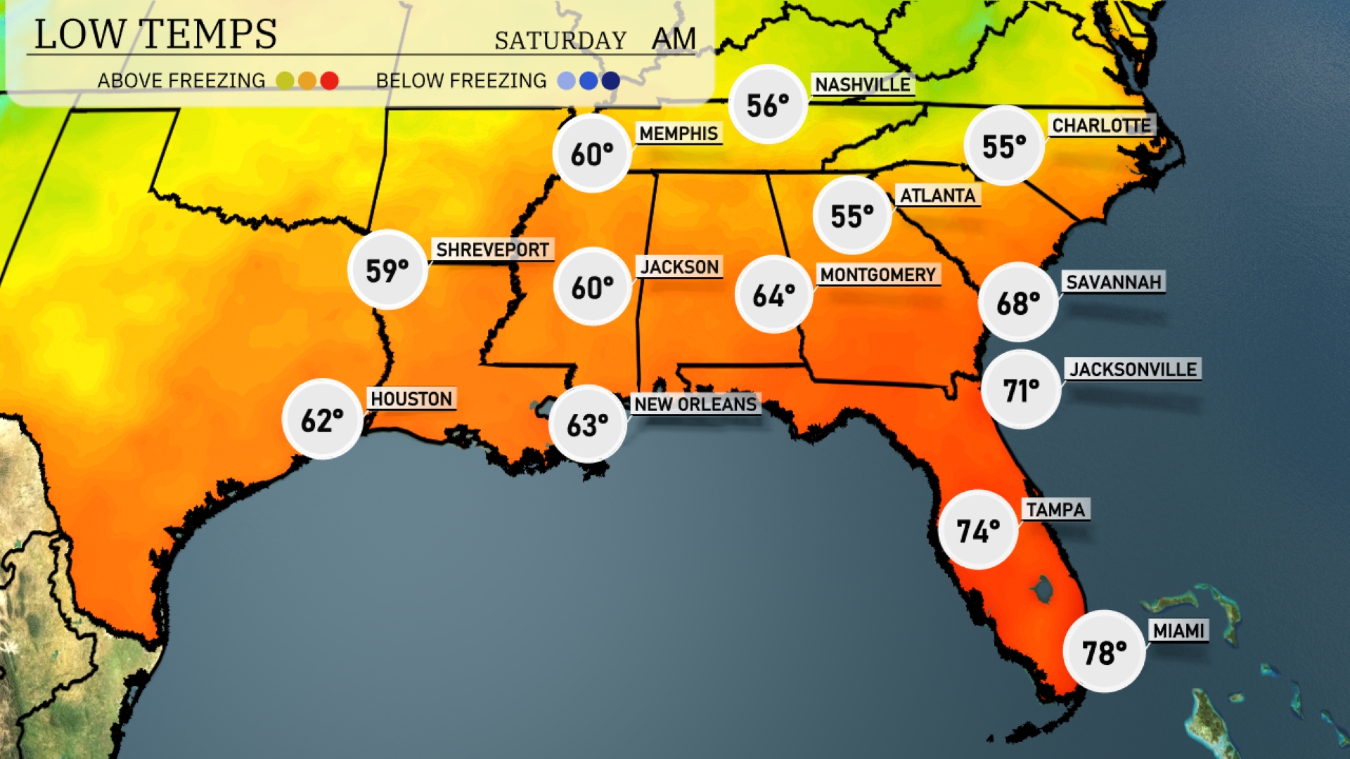
Nashville will chill to 56 degrees, while Atlanta sees a low of 55. Shreveport will experience a low of 59, with Jackson also sitting at 60. Montgomery will drop to 64 degrees, and in contrast, Miami remains warm at 78 degrees. Expect a mild night in Tampa with a low of 74 degrees.
High temperatures for the Southeast region tomorrow are trending above average, signaling a warm day ahead. Atlanta reaches a high of 70 degrees, while Memphis will warm up to 73. Montgomery is slightly cooler at 62 degrees due to lingering clouds, but Jacksonville will enjoy 83. In the Sunshine State, Tampa is hot at 87 degrees, and Miami follows suit with a high of 85. New Orleans and Shreveport round out the region at 77 and 76 degrees, respectively.
A cold front sweeping through the Southeast tomorrow will bring thunderstorms from Louisiana to Georgia, with notable activity expected in the morning hours. Cities like Birmingham and Montgomery should prepare for heavy rain and possible flash flooding, as rainfall accumulates quickly over the next 24 hours. Storms along the Gulf Coast, particularly near New Orleans, could be severe, with gusty winds and localized flooding being the main concerns. As the front exits the region, expect clearing skies and a cooler, drier air mass settling in by the weekend.
The UV index in Miami today reaches a very high 11, suggesting a brief burn time of just 11 minutes without protection. As we move into Saturday, the UV index remains high at 8, reducing the burn time slightly to 17 minutes.