Miami Weather Evening Update: From Sultry Skies to Storm Watches
By
Amy Freeze
A comprehensive evening weather update for Miami, showcasing upcoming temperature shifts and significant storm movements across the Southeast.
Dive into tonight’s forecast for Miami and an extensive look at how weather trends across the Southeast could impact your week.
Greetings from Amy Freeze! Tonight in Miami, expect partly cloudy conditions with steady temps around 80°F. The Southeast faces increased activity with a weather front bringing thunderstorms from the Gulf towards major cities. Looking ahead, Miami anticipates a range of weather from sunny days to potential thunderstorms. Stay tuned as we prepare for varied conditions through the week!
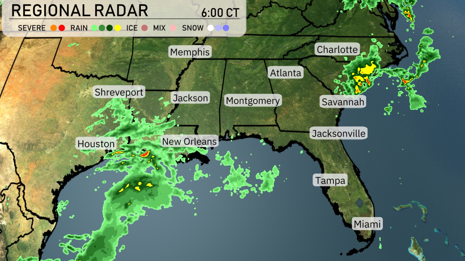
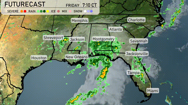
The Regional Radar shows a significant weather system affecting the Southeast. Intense thunderstorms are developing in the Gulf of Mexico, moving towards Houston and New Orleans. Shreveport and Jackson are experiencing consistent rain as the system progresses eastward. Light rain is also beginning to spread into the Montgomery area. The Carolinas, including Charlotte, are seeing scattered showers with potential for increased precipitation.
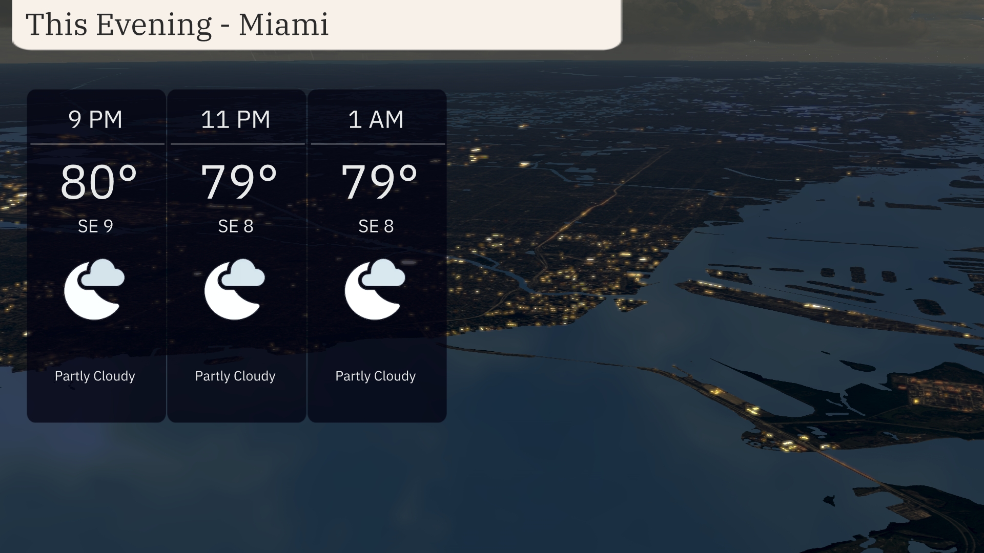
For this evening in Miami, expect partly cloudy skies with temperatures steady at 80 degrees at 9 PM, and slightly cooling to 79 degrees by 11 PM and maintaining through 1 AM. Winds will blow from the southeast at around 9 miles per hour, decreasing slightly to 8 miles per hour later in the night.
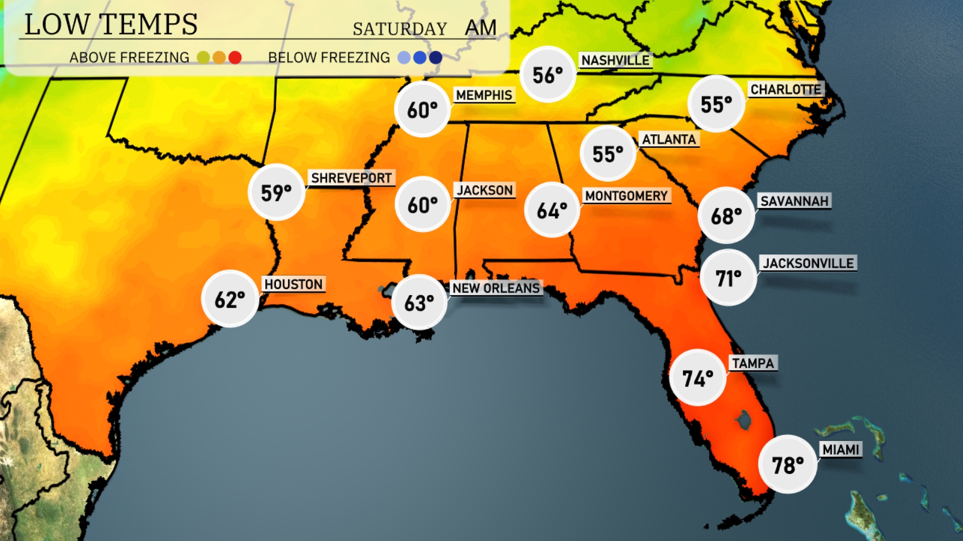
The Southeast is bracing for cooler overnight lows, with temperatures dropping significantly in key cities. Expect 55 degrees in Atlanta and 56 in Nashville, both showing notable decreases from previous nights. Montgomery will drop to 64 degrees, while Jackson sits at 60. To the south, New Orleans will see a low of 63 degrees, and Shreveport is projected to fall to 59. While Tampa will remain milder at 74 degrees, the overall trend indicates a notable chill settling over the region tonight.
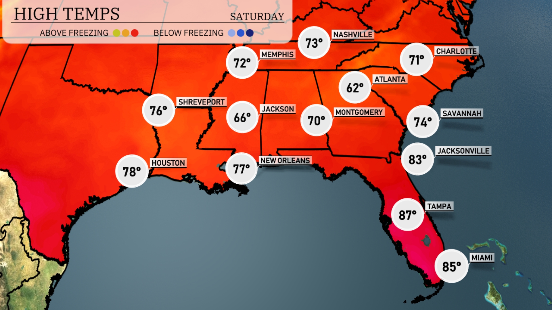
High temperatures tomorrow in the Southeast will be warming significantly above average. Atlanta expects a high of 70 degrees, while Jackson is a bit cooler at 66. New Orleans will see a pleasant 77 degrees, and further down in Florida, Tampa is set to reach 87 degrees, closely followed by Miami at 85. Jacksonville is poised for a warm 83 degrees, highlighting a trend of rising temperatures as we move into spring.
Expect an active weather day across the Southeast tomorrow. A significant cold front will sweep from the western to eastern parts of the region. Heavy rain and thunderstorms, especially from New Orleans to Montgomery, could cause brief flooding and dangerous travel conditions. Areas from Jackson to Jacksonville should prepare for severe weather, including strong gusty winds and isolated tornadoes during the day.
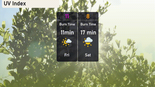
The UV index in Miami is extreme at 11 on Friday, with direct sunlight burn times as short as 11 minutes. On Saturday, it lowers slightly to 8, but still poses a risk with burn times around 17 minutes.
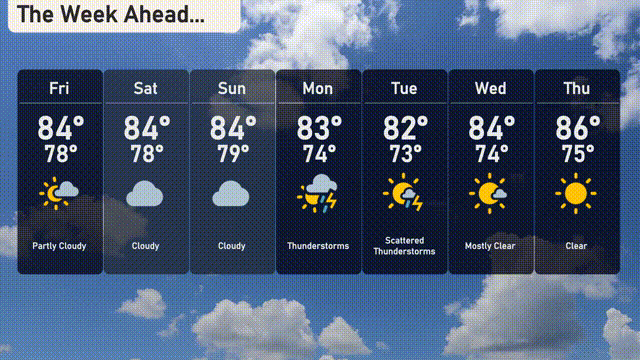
For the 7 Day Outlook in Miami:
Friday: Partly cloudy skies with a high of 84 degrees and a low of 78 degrees.
Saturday: Clouds continue to linger with a high of 84 degrees and a low of 79 degrees.
Sunday: Overcast conditions persist, highs reaching 84 degrees, lows at 79 degrees.
Monday: Thunderstorms are likely, high of 83 degrees and cooling to 74 degrees overnight.
Tuesday: Prepare for scattered thunderstorms, with the temperature peaking at 82 degrees and dropping to 73 degrees.
Wednesday: Mostly clear skies, expect a high of 84 degrees and a low of 74 degrees.
Thursday: Clear and sunny to round out the week, with a high of 86 degrees and a low of 75 degrees.