Explore our in-depth weather forecast for Miami and beyond, from sunny skies to imminent thunderstorms, and how these conditions could impact your plans.
Partly cloudy skies and the promise of storms—get the latest updates on Miami’s weather this week. From UV indexes to thunderstorm predictions, stay informed here.
https://www.youtube.com/watch?v=PGqLxZwAQ8c
Welcome to your weather update for Miami and the Southeast region. We’re seeing a variety of conditions from sunny skies to the threat of thunderstorms. This week’s forecast includes high temperatures across the Southeast with Miami at a cooler 88 due to an onshore breeze. Nighttime brings partly cloudy skies with lows in the mid-70s. Be sure to check out our detailed 7-day forecast for more. Always stay prepared and informed with the latest from your trusty forecast by Amy Freeze.
A tranquil morning across much of the Southeast is beginning to show signs of change. Showers are developing just southwest of New Orleans, stretching toward Houston. If you’re in Jackson or along the Gulf Coast, expect these showers to expand eastward into the afternoon. Skies remain clear from Memphis to Miami, offering a sunny start for these areas.
This evening in Miami will be partly cloudy with temperatures holding steady around 83 degrees at 9 PM and 11 PM, before slightly cooling to 82 degrees by 1 AM. Expect winds to shift from east-northeasterly at 10 mph to easterly at 7 mph.
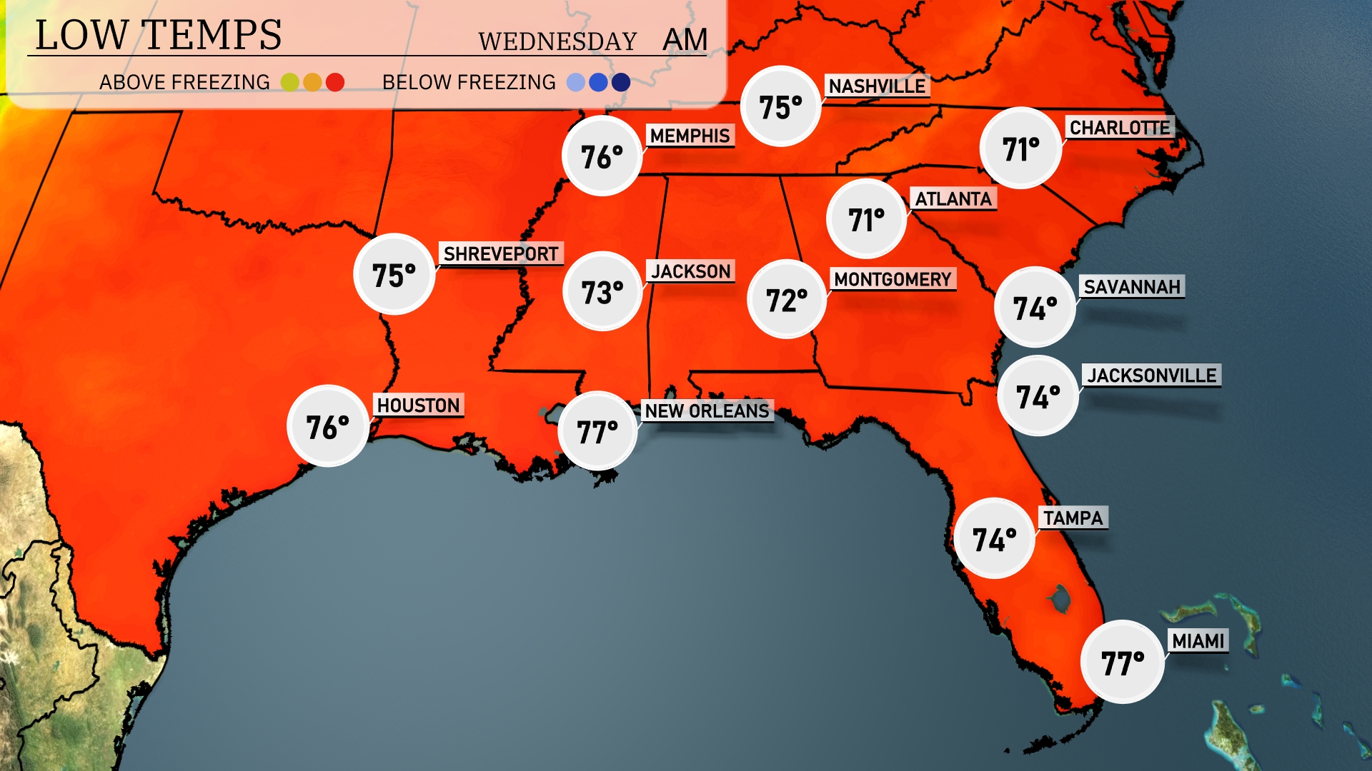
Tonight, Atlanta cools down to a low of 71 degrees. Memphis is expected to drop to 75, while Nashville will also see a low of 75 degrees. New Orleans remains mild at 77 degrees, and Montgomery hits 72 degrees. Jacksonville and Tampa will both stay around 74 degrees tonight, providing a warm atmosphere for those coastal areas.
Tomorrow, highs in the Southeast are heating up, with Nashville reaching a scorching 98 degrees. Memphis isn’t far behind, expected to hit 96 degrees, while Little Rock forecasts a high of 95 degrees. In Alabama, Montgomery will see temperatures soar to 97 degrees. Meanwhile, the coastal cities will enjoy slightly lower temps, with Jacksonville at 95 and Tampa reaching 94 degrees.
Expect a busy weather day for the Southeast tomorrow. A cold front brings a band of thunderstorms moving eastward through Louisiana, Mississippi, Alabama, and Georgia. New Orleans to Montgomery will experience heavy rain and potential brief, isolated thunderstorms. Be prepared for possible flash flooding in low-lying areas due to intense downpours.
The UV index in Miami will soar to a very high 11 today, so be cautious as the sun’s rays are intense! Expect a quick burn time of just 11 minutes in direct sunlight.
Here’s the 7-day forecast for Miami:
Tuesday: Expect isolated thunderstorms with a high of 87 degrees and a low of 79 degrees.
Wednesday: Thunderstorms are possible late in the day, with temperatures reaching a high of 85 degrees and a low of 77 degrees.
Thursday: A mix of sun and clouds with the high reaching 85 degrees and a low of 80 degrees.
Friday: Partly cloudy skies will bring a high of 87 degrees during the day, cooling down to 81 degrees at night.
Saturday: Another partly sunny day with temperatures climbing to 88 degrees and a low of 80 degrees.
Sunday: Partly cloudy with a daytime high of 87 degrees and nighttime low of 79 degrees.
Monday: Wrapping up the week with partly cloudy skies, a high of 85 degrees, and a low of 79 degrees.