Weather Whiplash: From Sunscreen to Umbrellas in Miami
By
Amy Freeze
Explore our detailed forecast of weather changes in Miami from high UV indices to looming thunderstorms that might just require you to keep both sunglasses and umbrellas at hand.
A week of weather contrasts awaits! From pleasant sunny days to potential severe thunderstorms, get the latest on Miami’s weather with Amy Freeze. Don’t miss out on comprehensive details including daily highs, lows, and safety tips. Follow the full story at our blog.
Welcome to our detailed coverage of the Southeast’s weather with Meteorologist Amy Freeze! This week in Miami, conditions swing from highs of 82 degrees to thunderstorms alerting of severe weather. With such fluctuating weather, we guide you on when to enjoy the sun and when to stay indoors. Features include UV index warnings, day-by-day forecasts, and exclusive meteorological insights. Read our full report for a thorough understanding of what to expect and how to prepare.
The Southeast region is currently experiencing a mix of weather conditions. Our radar shows light rain moving off the coast of Miami, bringing scattered showers to nearby areas. Jacksonville is clearing out from earlier precipitation, while Tampa remains dry for now. Across the Gulf Coast, New Orleans and Houston are enjoying clear skies with only a few clouds. As we look northward, clouds are increasing over Atlanta and Montgomery, signaling the potential for incoming rain showers. To the far north, light showers are present in the higher elevations of the Carolinas. Charlotte is under clear skies for the moment, offering a brief break from precipitation.
In Miami this afternoon, temperatures will be around 80 degrees at 3 p.m. with a southeast breeze at 8 miles per hour. By 5 p.m., expect temperatures to slightly drop to 76 degrees along with scattered thunderstorms moving in, accompanied by a south-southeast wind at 7 miles per hour. As the evening progresses to 7 p.m., anticipate cloudy skies with temperatures descending to 74 degrees and a northeast wind at 7 miles per hour.
Let’s take a look at today’s high temperatures across the Southeast. Shreveport is heating up to 89 degrees, making it the warmest spot in the region. Houston follows closely with a high of 87 degrees. Jackson enjoys a pleasant day at 83 degrees, while New Orleans also sees a high of 80.
Moving to the eastern part of the Southeast, Montgomery reaches 81 degrees, and Jacksonville is sitting at a comfortable 80 degrees. In Florida, Tampa and Miami both hit 80 and 81 degrees respectively, while Savannah is a bit cooler at 75 degrees.
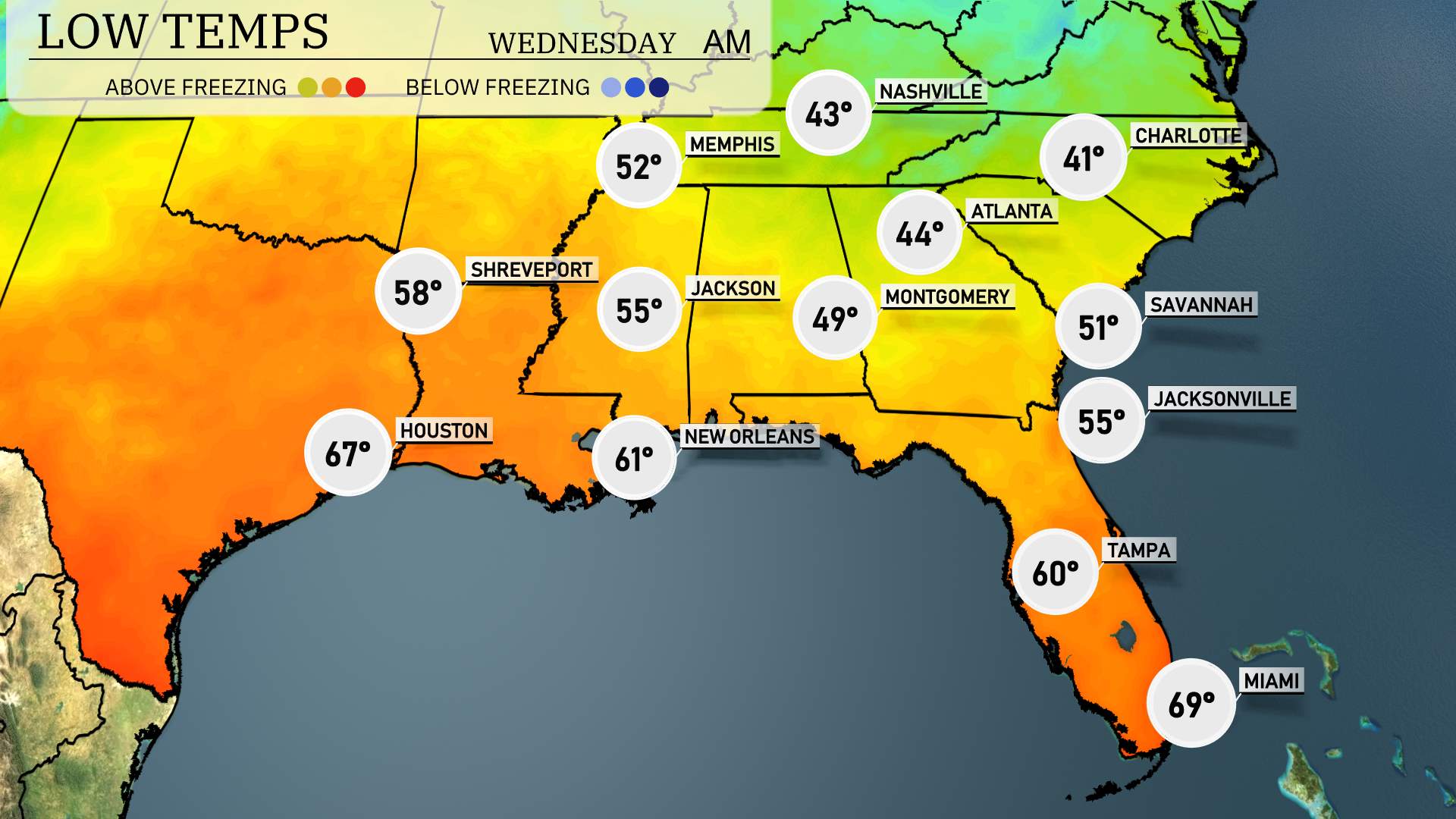
Now for the low temperatures in the Southeast region tonight. Memphis will see a low of 43 degrees, while Nashville dips even further to 41. Jackson is forecasted at 55 degrees, and Shreveport will experience a cooler 52. In the heart of Alabama, Montgomery is set to reach 49. Atlanta has a low of 44 degrees, and Savannah will rest at 51. Over in Florida, Jacksonville will be at 55, and Tampa will remain mild at 60 degrees. Miami wraps up the night at 69 degrees.
High temperatures for the Southeast region tomorrow are shaping up to be quite warm. In New Orleans, expect a high of 82 degrees, while Houston will warm up to 82 as well. Jackson is projected to reach 79 degrees, with Montgomery hitting 80 degrees. Atlanta is looking at a comfortable 75 degrees, while further south in Tampa, temperatures could soar to 86 degrees, making it one of the hottest spots in the region.
However, Charlotte is cooler with a high of 69 degrees, showing a slight deviation from the overall pattern.
A strong cold front brings an active weather pattern across the Southeast on Wednesday. Expect a line of storms with potential for heavy thunderstorms and isolated severe weather from New Orleans to Montgomery. Early morning commuters in Atlanta should prepare for wet conditions as the front moves through. Rain and storms will continue into Jacksonville and Savannah later in the day. Be cautious of weather warnings as conditions may escalate with the frontal passage. Following the storm, a cooling trend with dry skies is forecasted, bringing some relief as the system clears by the weekend.
“The UV index in Miami is very high, with a 9 on Tuesday, indicating a burn time of just 15 minutes in direct sunlight. On Wednesday, the index rises to 10, with a burn time of only 12 minutes.