Evening Breezes and Sunny Teases: Miami’s Weekly Weather Digest
By
Amy Freeze
Explore the contrasts in Miami’s weather from clear skies to potential showers, and get a sneak peek at the Southeast’s weekly forecast.
This week in Miami, enjoy mostly clear skies with daytime highs at a pleasant 89°F. Be prepared for potential showers on Friday and keep an eye on the Southeast for fluctuating temperatures.
Welcome to this week’s Miami weather roundup! Expect mostly clear skies and warm temperatures, hovering around 89°F. A cold front moving through the Southeast may shake things up by the weekend, leading to potential showers. Don’t let it catch you off-guard! Gear up for changes with our complete forecast and daily tips to make the most of your week, whether it’s sunny or drizzly!
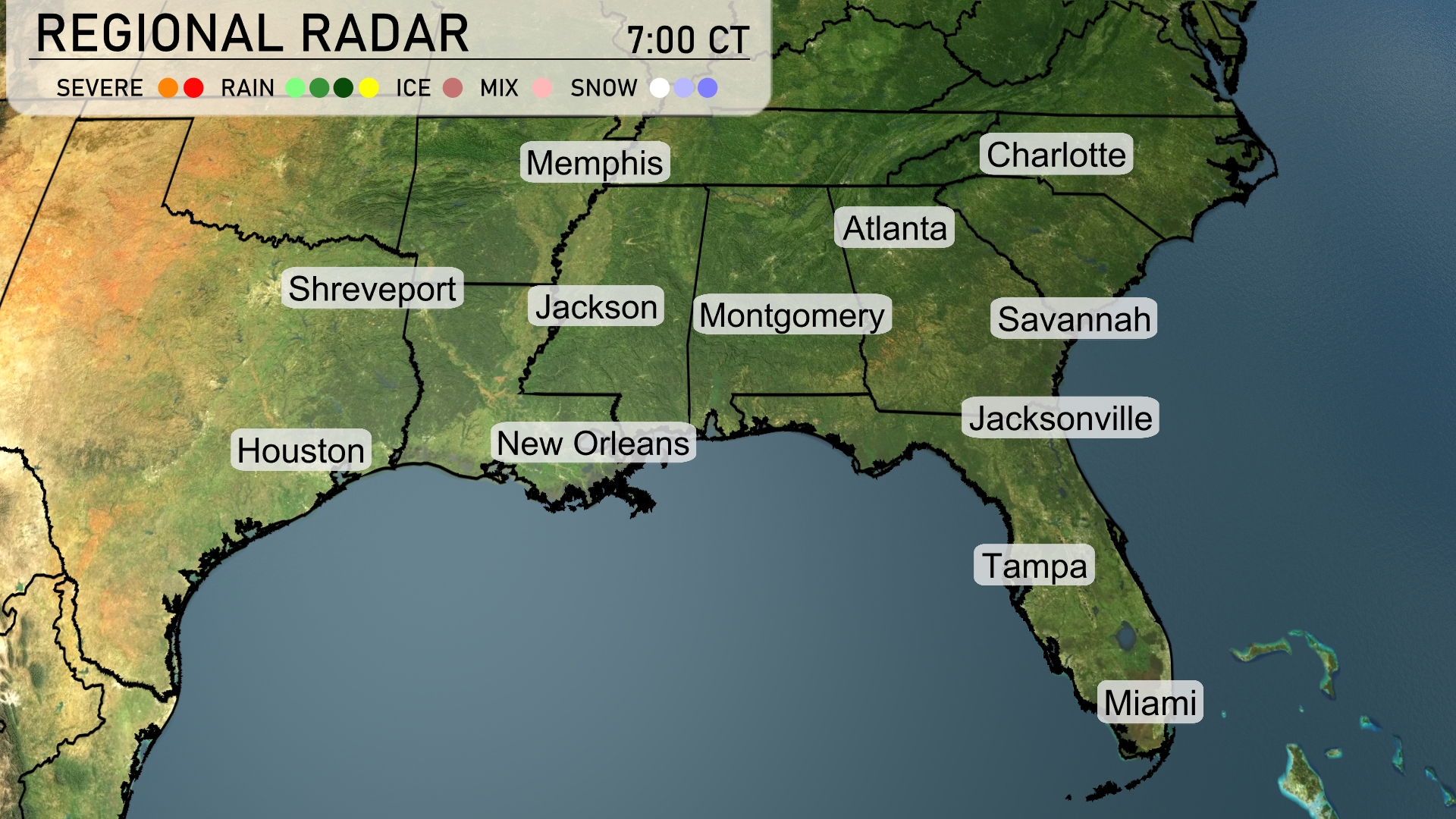
A line of showers is stretching across South Alabama and moving into the Florida Panhandle, with Miami under mostly clear conditions. Montgomery is experiencing light rainfall which is expected to continue through the morning hours. Meanwhile, over in Houston and New Orleans, skies are mostly clear. The northern sections, including Memphis and Charlotte, remain dry with overcast skies spreading eastward.
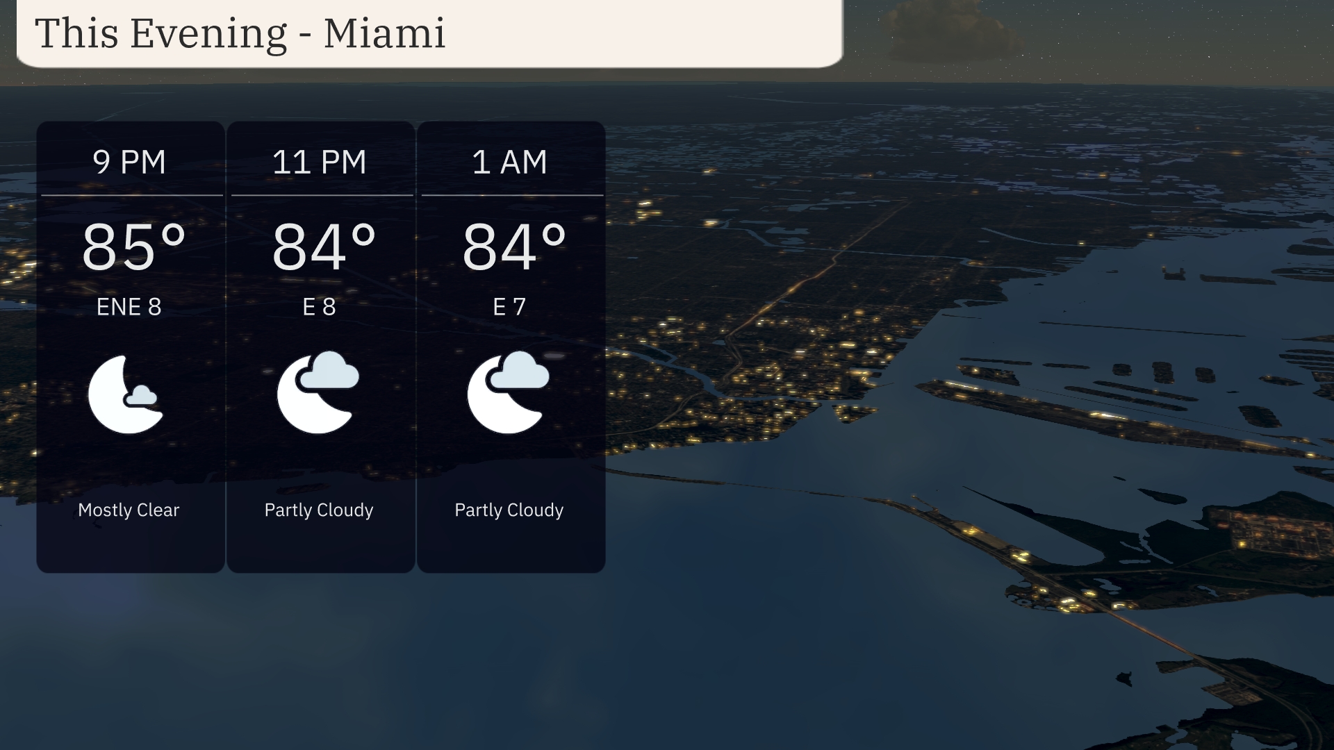
For this evening in Miami, temperatures will hover around 85 degrees at 9 PM, slightly cooling to 84 degrees by 1 AM. Expect mostly clear to partly cloudy skies, providing a pleasant night backdrop. Winds will be gentle from the east-northeast at 8 mph, shifting to an eastward direction at 7 mph by late night. The steady breeze should keep the atmosphere refreshing as you enjoy the evening.
Tonight, Memphis will see a low of 76 degrees, while Nashville drops to 75. Montgomery is expected to cool to 77 degrees. In Atlanta, the temperature will fall to 76 degrees, with Savannah holding at a warmer 80. Jacksonville will also stay mild at 79 degrees.
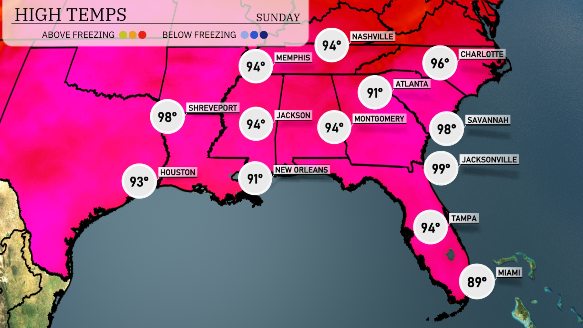
Tomorrow, the Southeast will see sweltering highs with Jacksonville reaching a scorching 99 degrees, while Savannah isn’t far behind at 98 degrees. Atlanta will peak at 94 degrees, consistent with the heat wave impacting the region. New Orleans sees a high of 91 degrees, slightly below normal but still feeling that summer heat. In Memphis and Jackson, temperatures will both climb to 94 degrees, showcasing the trend of elevated readings across the southeast. Houston rounds out the region with a warm 93 degrees, as high-pressure continues to dominate the area.
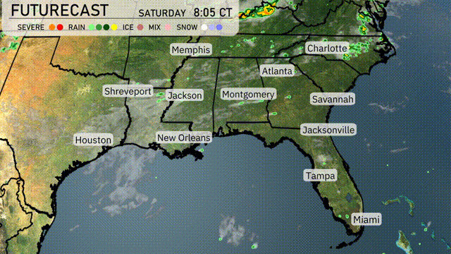
A cold front is expected to move through the Southeast tomorrow, starting in the morning from Houston to New Orleans. This front will bring scattered thunderstorms and heavy rainfall, with potential for isolated severe weather including strong winds and localized flooding. By midday, the storms shift eastward into areas like Montgomery and Atlanta, possibly impacting travel with wet and windy conditions. Temperatures behind the front will drop slightly but still remain warm, with clearing skies noted late Wednesday evening. Look for improved conditions as the front pushes out toward Savannah and the Florida coast by late afternoon.
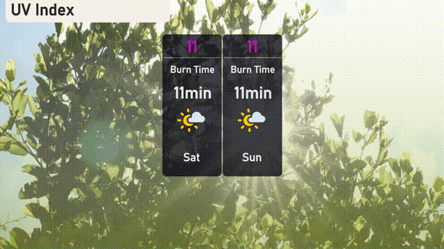
Expect an extreme UV index of 11 in Miami on both Saturday and Sunday, with sun exposure burn times as short as 11 minutes. Keep sun safety top of mind this weekend: sunscreen, hats, and shade breaks are essential if you’ll be outdoors!
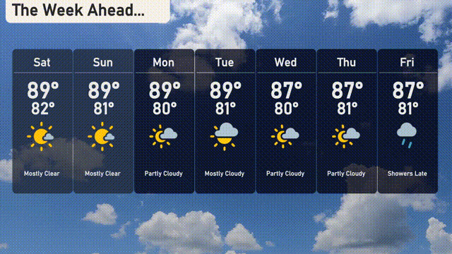
Here’s the 7-day forecast for Miami:
Saturday: The day brings mostly clear skies with a high of 89 degrees and a low of 82 degrees.
Sunday: Another mostly clear day with temperatures reaching up to 89 degrees and a low of 81 degrees.
Monday: Expect mostly clear conditions again, with a high of 89 degrees and a low of 81 degrees.
Tuesday: Partly cloudy skies are anticipated, with a high of 89 degrees and a low of 80 degrees.
Wednesday: It stays partly cloudy, with the temperature peaking at 87 degrees and a low of 80 degrees.
Thursday: Continuing with partly cloudy conditions, expect a high of 87 degrees and a low of 81 degrees.
Friday: Showers are likely late in the day, with a high of 87 degrees and a low of 81 degrees.
Enjoy your week!