Miami’s Weather Whiplash: Clear Skies to Stormy Evenings
By
Amy Freeze
Explore how Miami's weather swings from clear, sunny skies to stormy nights and what to expect in the Southeast over the week.
Tonight in Miami expect partly cloudy skies with imminent showers. While the Southeast faces fluctuating conditions, from sizzling temperatures to potential storms, stay tuned for your daily weather wisdom.
This blog post dives into the dynamic weather patterns affecting Miami and surrounding Southeast areas. Learn about the fluctuating weather from sunny highs to stormy lows, and what this means for your weekly planning. With expert insights, stay weather-wise and prepared for anything. Don’t forget to check the linked detailed forecast!
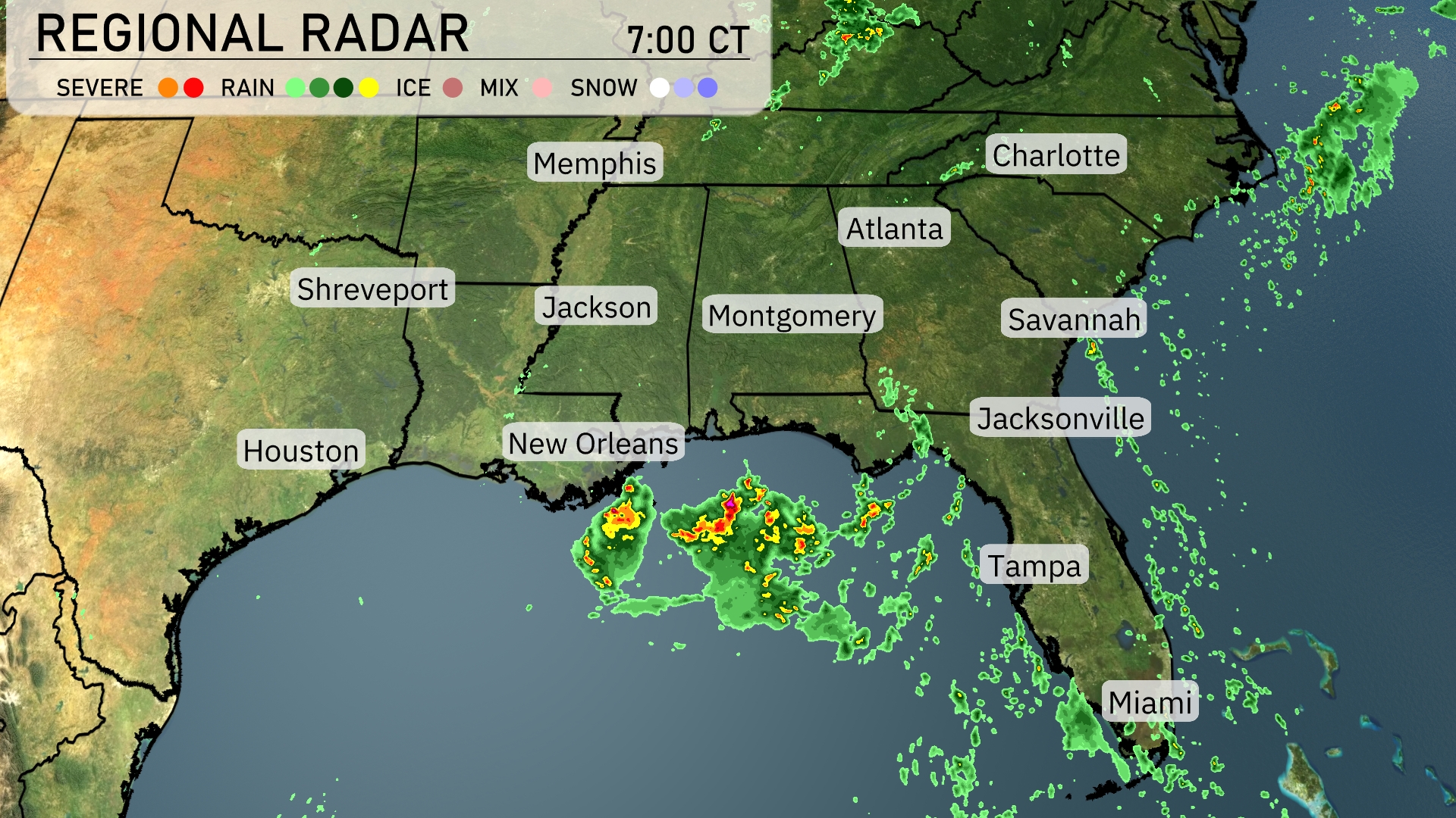
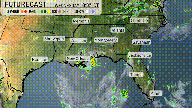
A cluster of strong storms with heavy rain is currently impacting the Gulf Coast near New Orleans. As these storms drift, heavy showers are expected to spread eastward toward Montgomery. Scattered rain showers are evident around the coastal regions of Mississippi and Alabama, offering relief from recent dry conditions. Cities like Atlanta, Charlotte, and Jacksonville are enjoying clear skies, although clouds are beginning to build across central and northern Georgia, indicating possible afternoon showers.
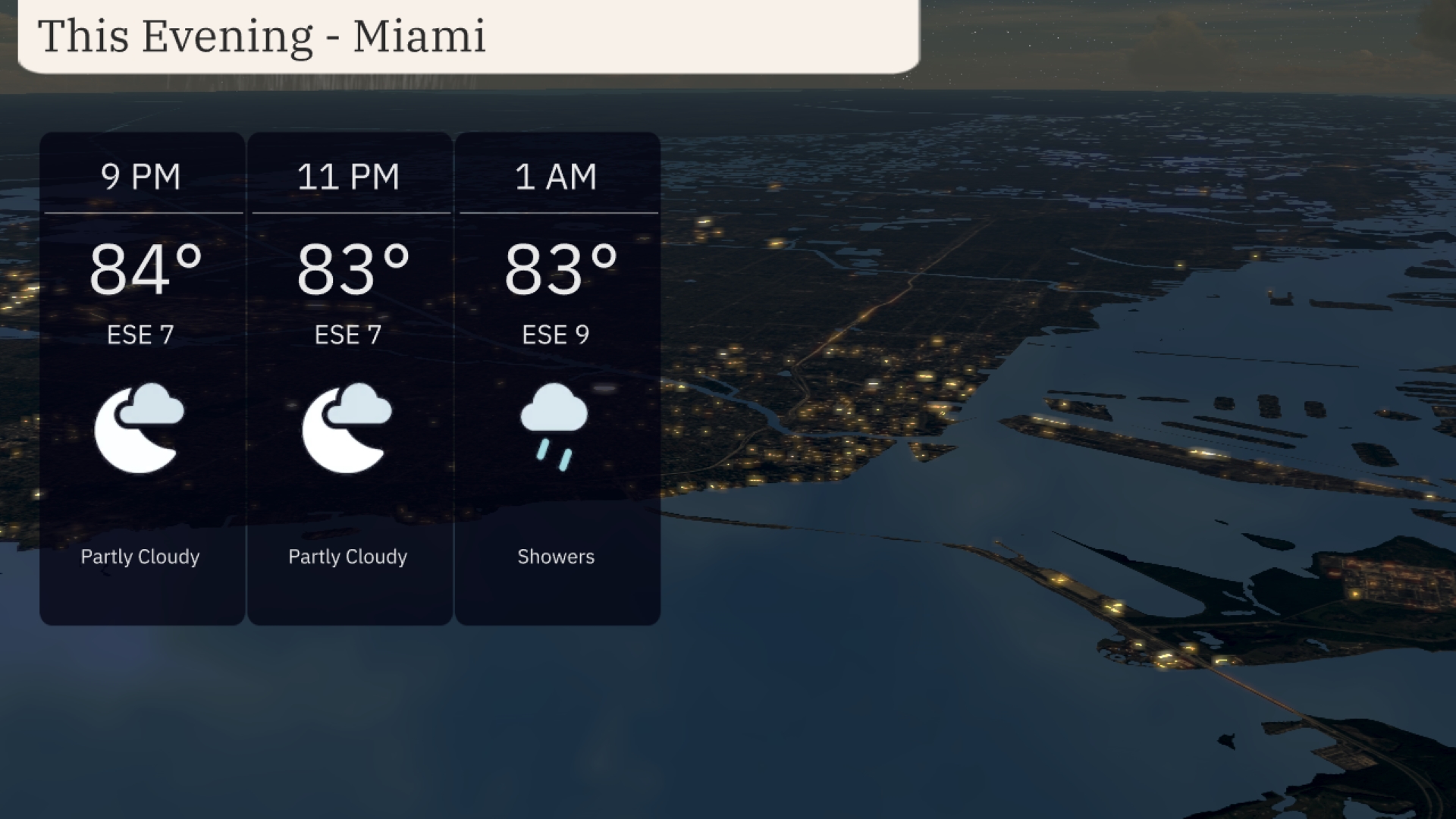
For the evening in Miami, temperatures will stay warm, holding steady at 84 degrees at 9 PM and slightly dipping to 83 degrees by 11 PM. Winds from the east-southeast at 7 miles per hour will provide a gentle breeze as partly cloudy skies transition into the night. By 1 AM, showers are expected with winds increasing slightly to 9 miles per hour.
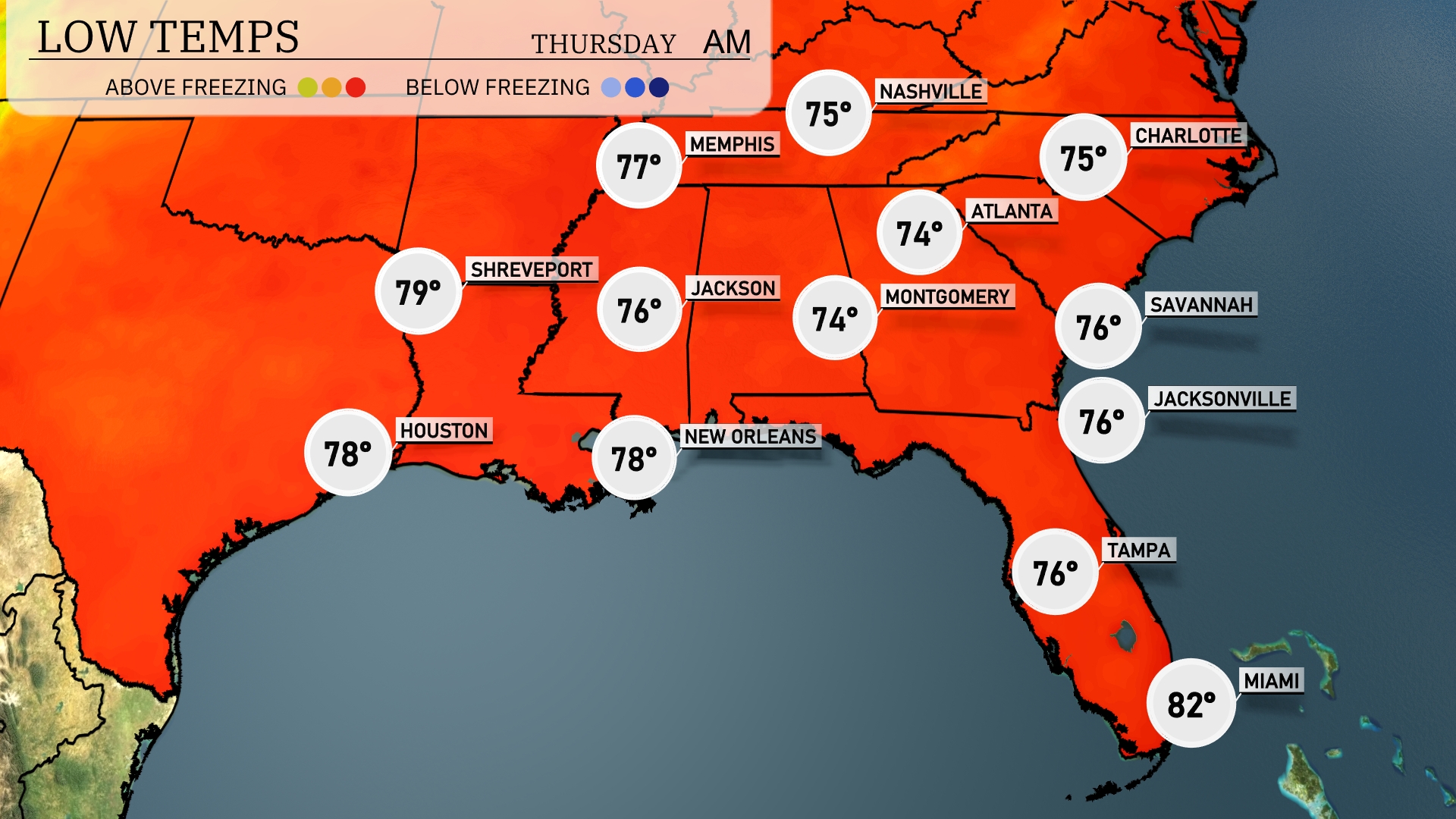
Tonight in Memphis, expect a low of 77 degrees. Jackson will see temperatures drop to 76, while Shreveport cools to 79. New Orleans remains mild at 78 degrees. Atlanta can expect a low of 74, with Nashville dipping to 75.
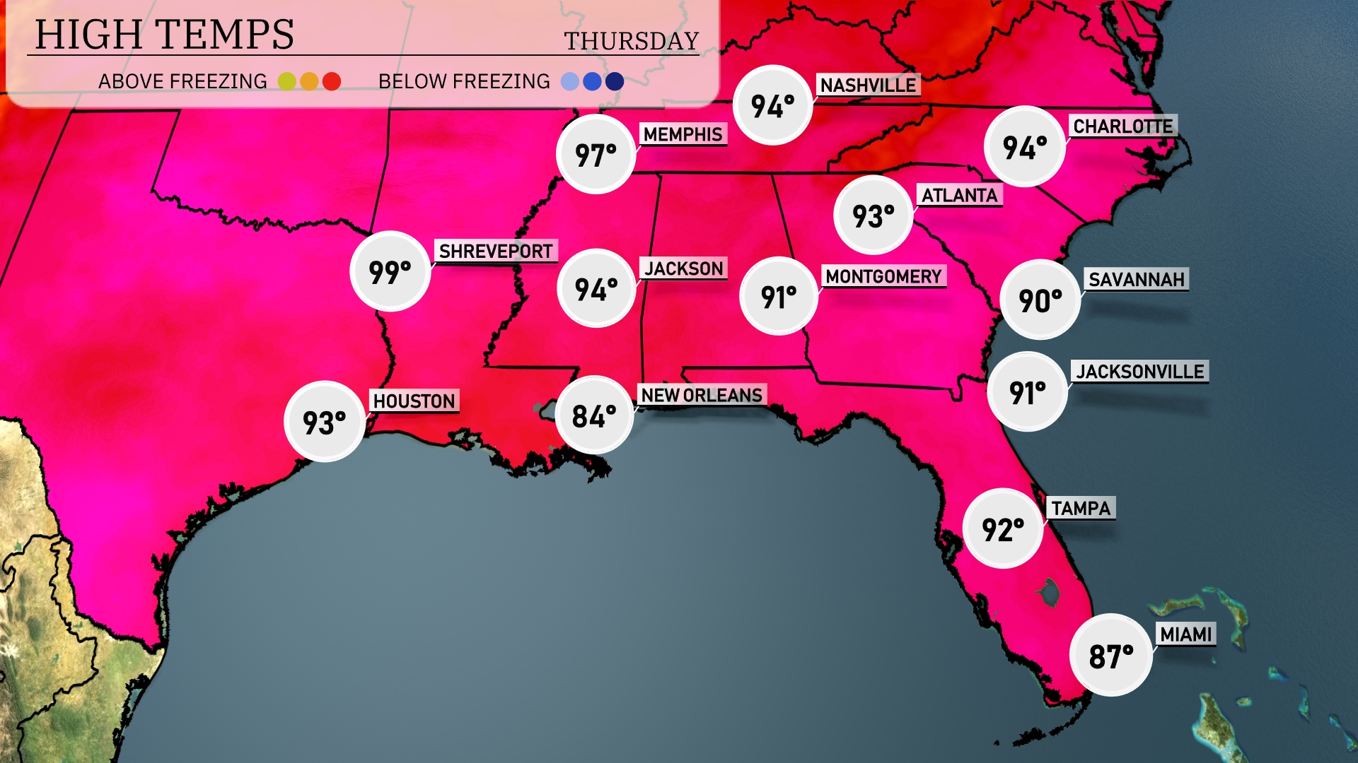
Tomorrow, Shreveport is looking at a sizzling high of 99 degrees, while Houston will see warm conditions with a high of 93. Memphis can expect a high of 97, contributing to a trend of above-average temperatures across the region. Jackson is in for a high of 94 degrees, and Montgomery will reach 91. In contrast, New Orleans is cooler at 84 degrees, making it one of the more moderate spots in the Southeast.
A line of thunderstorms is expected to move across the Southeast tomorrow, with particularly strong activity from New Orleans to Montgomery. Residents in Atlanta should prepare for stormy conditions during the morning commute. There’s potential for severe weather, including damaging winds and heavy rain, which could lead to localized flooding. After the storms pass, expect clearing skies and slightly cooler temperatures heading into Thursday. Stay weather aware, especially in high-risk areas.
Today in Miami, expect a very high UV index of 10, with a potential burn time of just 12 minutes when outdoors. As for tomorrow, the UV index eases to 8, though still high, with an estimated burn time of 17 minutes.
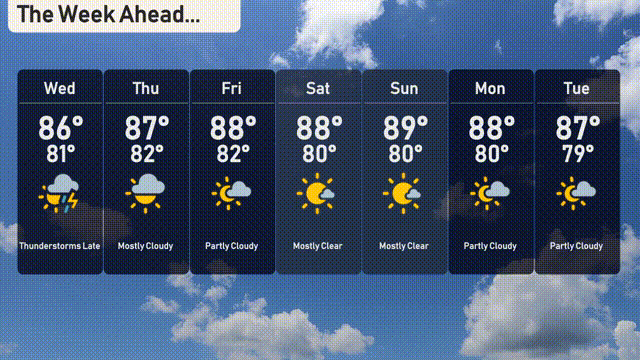
For the Miami 7-day forecast:
Wednesday: Thunderstorms developing late in the day with a high of 86 degrees and a low of 81 degrees.
Thursday: A mix of sun and clouds with highs around 87 degrees, cooling to 82 degrees at night.
Friday: Enjoy partly cloudy skies with daytime temperatures reaching 88 degrees and lows of 80 degrees.
Saturday: Mostly clear skies, warm with a high of 88 degrees and an overnight low of 80 degrees.
Sunday: Similar to Saturday, mostly clear and temperatures peaking at 89 degrees, dropping to 80 degrees after sunset.
Monday: Partly cloudy, continuing the warmth with a high of 88 degrees and a low of 80 degrees.
Tuesday: Partly cloudy skies with a high of 87 degrees and a low near 79 degrees.