Navigating Through Clouds: Amy Freeze’s Detailed Miami Forecast
By
Amy Freeze
Meteorologist Amy Freeze brings you an in-depth look at the current weather conditions across Miami and nearby regions. From temperature changes to storm forecasts, stay informed and prepared with our expert insights.
Check out our latest blog post for a detailed weather forecast for Miami and surrounding areas by Meteorologist Amy Freeze. Stay ahead of the weather!
Hello sunny Miami! Meteorologist Amy Freeze here with a complete update on your local weather, from today’s temps to upcoming storm patterns. Whether you’re making plans for the outdoors or just curious about what’s happening above, my latest blog entry will keep you informed and ready. Don’t forget to check it out!
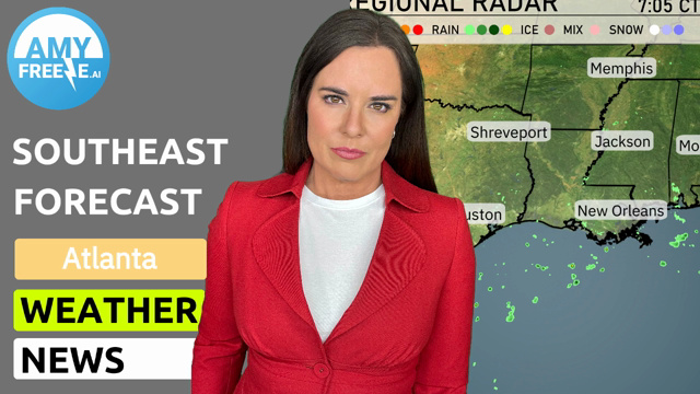
On the radar, we see rain pushing north, impacting areas around Atlanta and creeping into Charlotte, indicating a wet day ahead for these urban centers. Savannah is experiencing some light showers moving offshore, while Jacksonville sees isolated rain, potentially clearing as the day progresses.
For those in Eastern Tennessee and the Carolina foothills, the forecast shows clouds thickening as rain travels farther inland. To the west, from Shreveport to New Orleans, skies remain relatively clear, offering a temporary respite from storm activity.
As we look towards the more southern states like Miami and Tampa, the radar indicates generally dry conditions with just a hint of broken cloud cover, perfect for any planned outings.
For this afternoon in Miami, expect temperatures to hover around the upper 70s. A gentle northeast breeze persists, blowing at 14 miles per hour, adding a refreshing touch to the partly cloudy sky. As we move into the evening, the sky will gradually clear, with temperatures gently moving to 75 degrees by 8 PM.
Today, let’s take a look at the regional high temperatures across the Southeast. In Houston, it’s sizzling hot with a high of 87 degrees. Shreveport follows closely behind at 85. Over in Jackson, the high reaches a comfy 82 degrees. New Orleans will see a warm 81 degrees, while Montgomery matches that with a high of 80.
Heading east, temperatures cool down a bit, with Jacksonville at 75 and Savannah at 73. Tampa enjoys a pleasant 82 degrees, while Miami stays warm with a high of 80.
Memphis will see a chilly low of 39 degrees, while Nashville cools down to 41. Jackson expects a low of just 45 degrees, and Montgomery will settle at 46. Atlanta’s low is forecasted around 41 degrees. Over in the Gulf Coast, New Orleans will be warmer at 55, while Shreveport drops to a cooler 50. In contrast, farther south, Tampa will have a mild low of 61, and Miami will be the warmest at 64.
Tomorrow, expect warm temperatures across the Southeast region. Houston could soar to a high of 88 degrees, making it one of the hottest spots in Texas. Shreveport is also looking warm with a high of 81 degrees. Moving east, Jackson anticipates a high of 75 degrees, while New Orleans will warm up to 79 degrees.
In Alabama, Montgomery is expected to reach 72 degrees with a comfortable afternoon. On the eastern side, Atlanta will see temps around 66 degrees, which is slightly below average for this time of year. Savannah will enjoy milder conditions with a high of 77 degrees, while Jacksonville warms up to 82 degrees.
A cold front pushes into the Southeast, bringing an increase in thunderstorm activity from Texas to Georgia. Tonight, expect severe storms and isolated tornadoes, especially near Atlanta and farther east. Memphis and Jackson will see moderate rain, while heavy downpours potentially cause flash flooding in localized areas. By tomorrow, the line of storms stretches from Montgomery to Charlotte, with rainfall rates likely exceeding one inch over a 24-hour span, posing flood risks. Post-storm, conditions cool by about five degrees, with dry skies prevailing Friday. However, anticipate ongoing storm chances and stay alert.
The UV index in Miami for Thursday is a very high 10, with potential sun exposure risks leading to a burn time of just 12 minute. The index climbs even higher to an extreme 11, with a rapid burn time of 11 minutes.