Miami Weather Update: From Sunny Beach Days to Stormy Afternoons
By
Amy Freeze
This week in Miami brings a mix of high temperatures, potential thunderstorms, and plenty of sunshine. Stay informed and prepared with our comprehensive forecast.
Join us for a detailed look at Miami’s weather for the week, from beautiful sunny skies to important storm warnings. Prepare for everything nature has to offer!
This week, Miami enjoys mostly sunny days with highs close to 90 degrees, perfect for outdoor activities. However, a cluster of storms could bring rain and wind to the area. Stay updated as conditions evolve with our daily Miami forecast reports. Don’t forget, the UV index is high – protect yourself from sunburn!
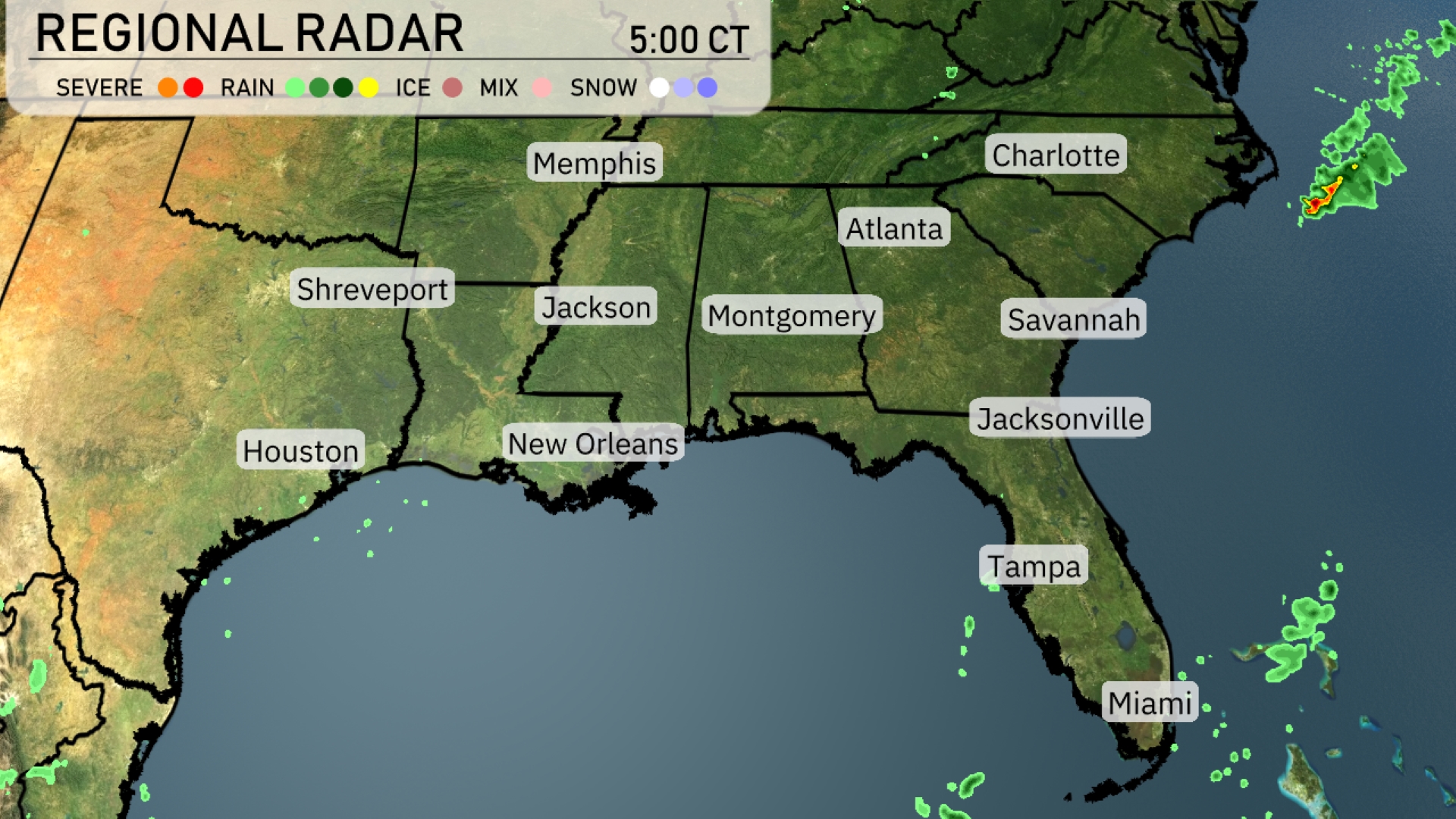
A cluster of storms is off the southeast coast, edging closer to the Carolinas, bringing rain and potential wind gusts. Scattered rain showers are forming over the Gulf of Mexico, likely affecting coastal areas such as Tampa and Miami. Cloud cover is increasing over northern Georgia, suggesting incoming rainfall for Atlanta. Across the rest of the region, including Montgomery and Shreveport, conditions remain mostly dry and clear.
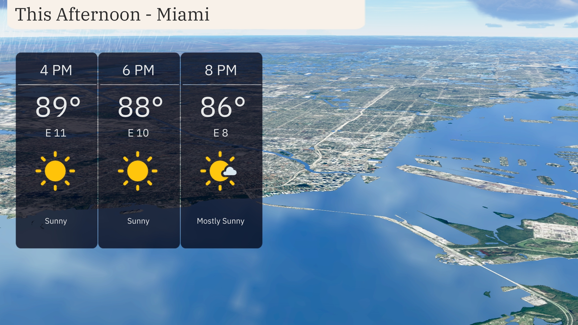
This afternoon in Miami, temperatures hold steady in the high 80s, reaching up to 89 degrees by 4 PM. Expect a light easterly breeze around 11 mph, gradually decreasing to 8 mph by evening. Sunny skies dominate, with only a few clouds appearing as the sun begins to set. Perfect afternoon for outdoor activities with plenty of sunshine and a gentle breeze.
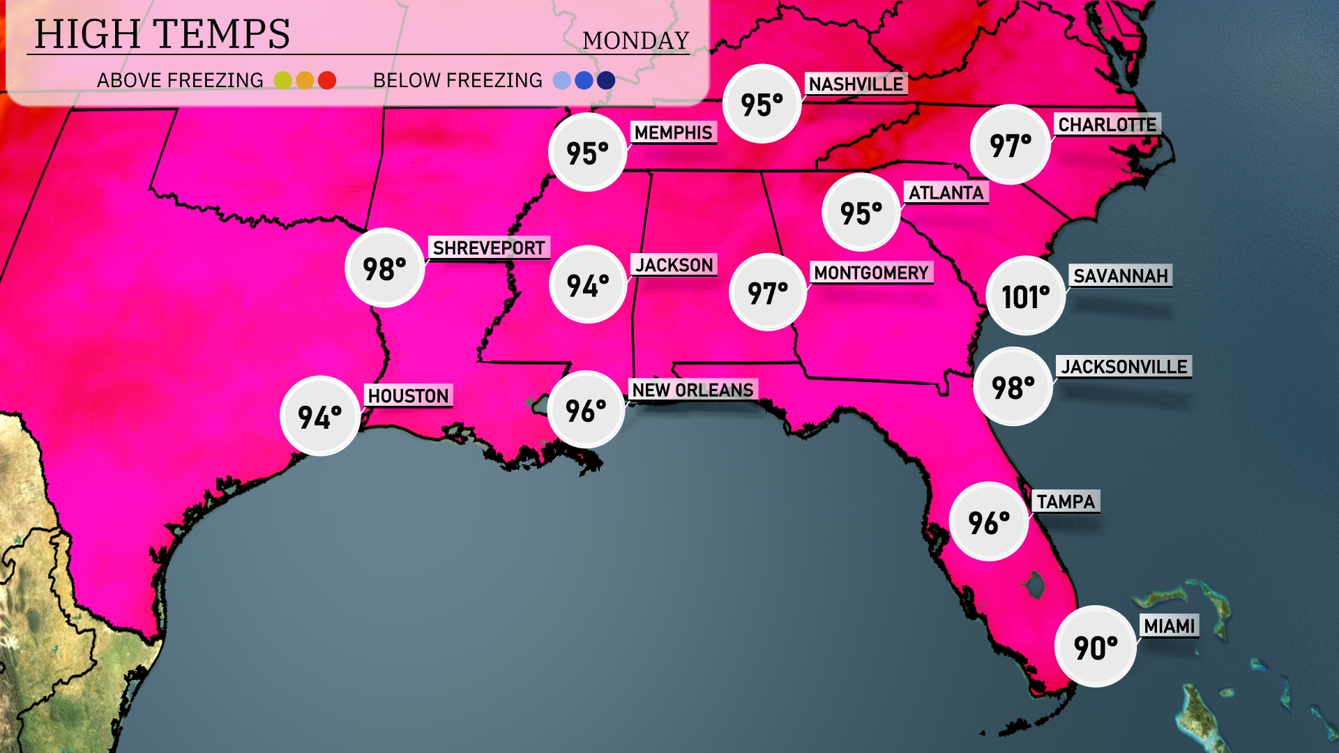
Today’s high temperatures in the Southeast are on the rise. In Jacksonville, expect a sizzling high of 98 degrees, while Savannah is even hotter at 101. Across the border in Alabama, Montgomery reaches 97 degrees, contributing to a warm day across the region. New Orleans will see a high of 96, a bit more moderate compared to the heat further north. Meanwhile, Tampa enjoys slightly cooler temperatures at 96, with Miami at 90 degrees, highlighting some regional variability today.
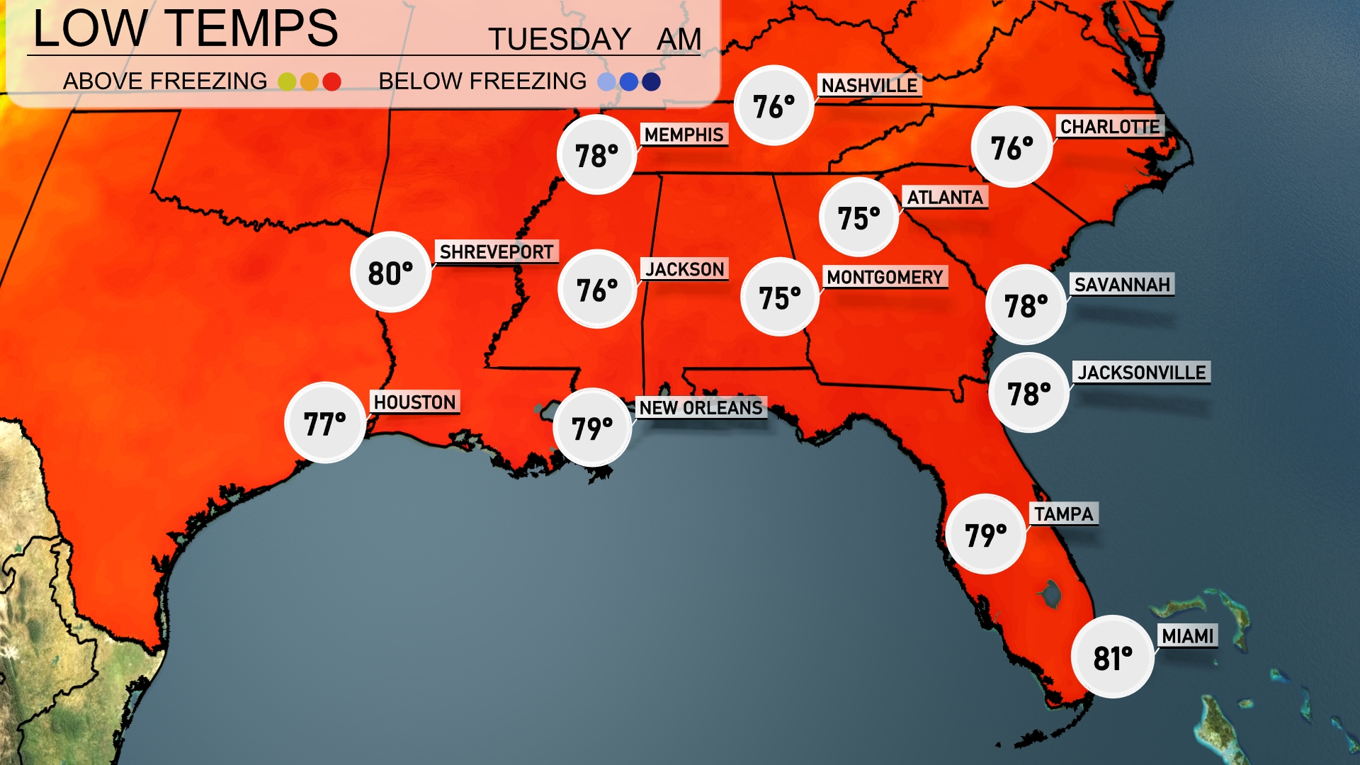
Tonight, Memphis will see a low of 76 degrees. Expect 75 degrees in Montgomery and 76 in Jackson. Shreveport is forecasted to drop to 80 degrees, while New Orleans will remain at 79. In contrast, temperatures will cool down to 78 in both Savannah and Jacksonville, making for comfortable conditions across the Southeast.
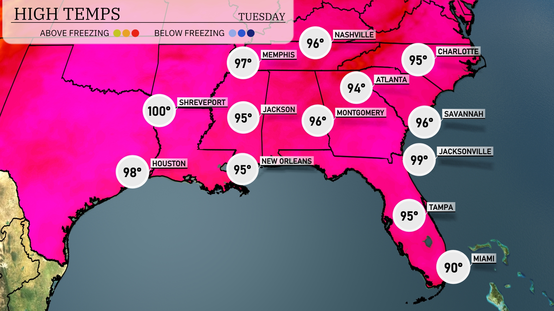
Tomorrow, Shreveport reaches a sizzling 100 degrees, while Houston is expected to hit 98. In Jackson, temperatures will peak at 95, and New Orleans will also see a high of 95. Atlanta’s high will be around 94, and Jacksonville is set to soar to 99. The Southeast is experiencing above-average temperatures due to a dominant high-pressure system influencing the region, bringing hot and dry conditions.
A cold front will push through the Southeast tomorrow, sparking thunderstorms from Shreveport to Jacksonville. Expect severe weather risks, including heavy downpours and damaging wind gusts. Cities like New Orleans and Atlanta may see particularly strong storms during the afternoon commute. By evening, the storm front advances toward Savannah, so keep an eye on the changing conditions. Behind the front, a cooler air mass will bring relief, dropping temperatures by about 5 to 10 degrees.
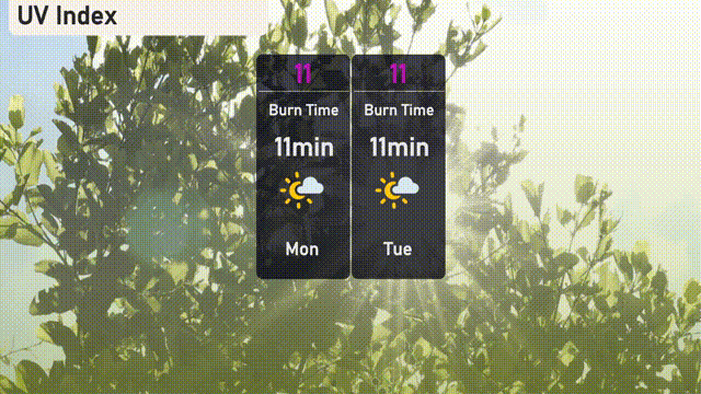
For Miami, the UV index will be very high at 11 today with a burn time of just 11 minutes in direct sunlight. Be sure to apply sunscreen and seek shade during peak hours. On Tuesday, the UV index remains steady at 11, so continue taking precautions to prevent sunburn.