Miami’s Weekly Weather Forecast: Navigating Through Sun and Storms
By
Amy Freeze
Dive into this week's weather dynamics in Miami, from balmy afternoons to thunderstorm advisories. Discover how to prepare and what to expect with our detailed forecast.
This week in Miami: From sunny skies to storm warnings, know when to enjoy the sun and when to take cover. Click for the full forecast and safety tips!
Stay updated with Miami’s comprehensive weekly weather forecast. From today’s partly cloudy skies to the impending thunderstorms, we cover all the insights you need to navigate the fluctuating conditions. Key highlights include temperature swings, storm predictions, and crucial safety tips tailored for each day. Follow our daily updates for timely weather alerts and preparation advice. Don’t miss out on enjoying Miami’s weather safely!
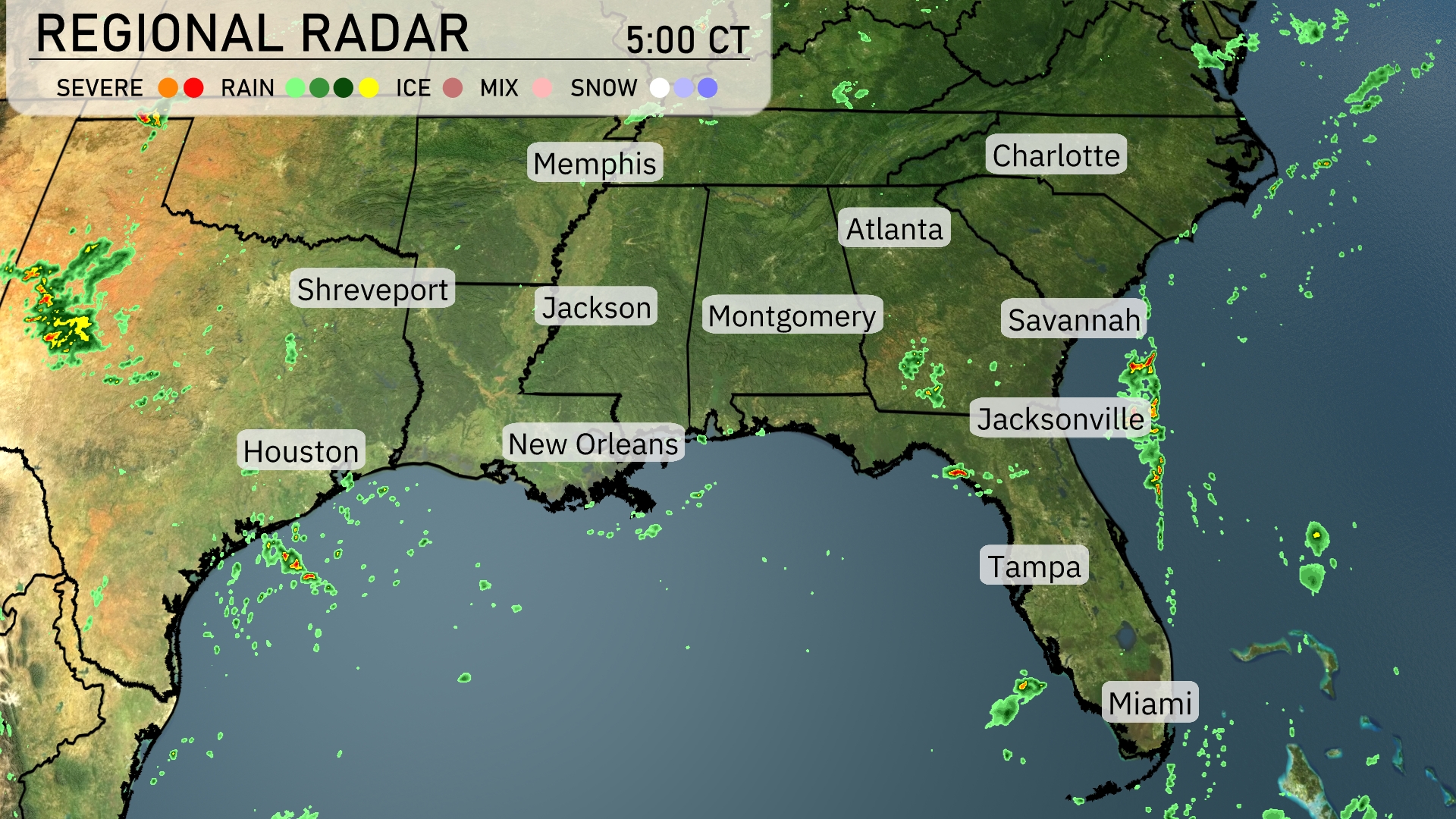
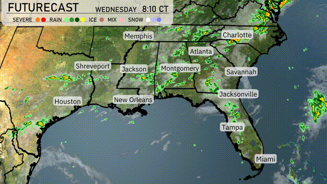
A line of rain showers is currently sweeping across parts of Georgia, moving towards the Carolinas, bringing moisture to Savannah and its surroundings. Jacksonville is experiencing persistent cloud cover with scattered showers while further south, Miami is staying mostly dry. The southwest corner, including Houston, remains calm despite a few localized showers offshore. Over the northern Gulf Coast, New Orleans is enjoying clear skies, but keep an eye out as patterns indicate potential precipitation shifts.
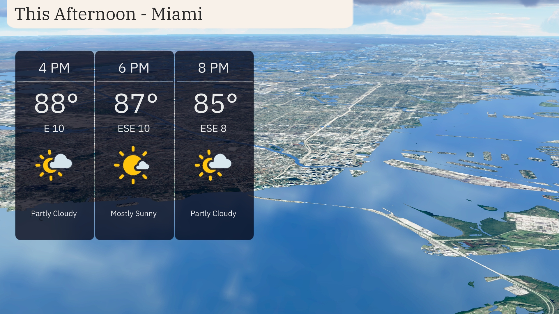
This afternoon in Miami, temperatures will hover around 88 degrees at 4 PM, then slightly decrease to 87 degrees by 6 PM and 85 degrees at 8 PM. A gentle easterly breeze at 10 miles per hour will shift a bit to the east-southeast. Enjoy a partly cloudy sky early on, transitioning to mostly sunny conditions mid-afternoon, before clouds begin to gather again later.
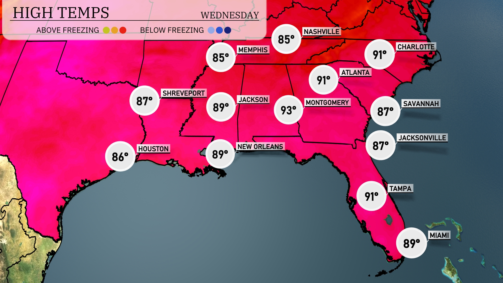
In the Southeast, we’re seeing some notable temperature variances today. Montgomery is heating up to a sizzling 93 degrees, while Atlanta closely follows with a high of 91. New Orleans stays warm at 89 degrees, with a similar forecast for Jackson. Over in Florida, Tampa enjoys a high of 91, while Jacksonville and Savannah are a bit cooler at 87 degrees each. Meanwhile, Shreveport shows a comfortable high of 87 degrees, perfect for outdoor activities.
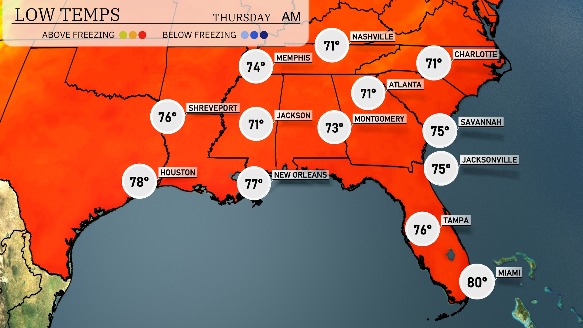
Tonight, expect Memphis to drop to 74 degrees, while Nashville will see a low of 71. In Jackson, the temperature will settle at 71 degrees, with Montgomery hitting 73. Atlanta also falls to 71 degrees, and further south, New Orleans remains warm at 77 degrees.
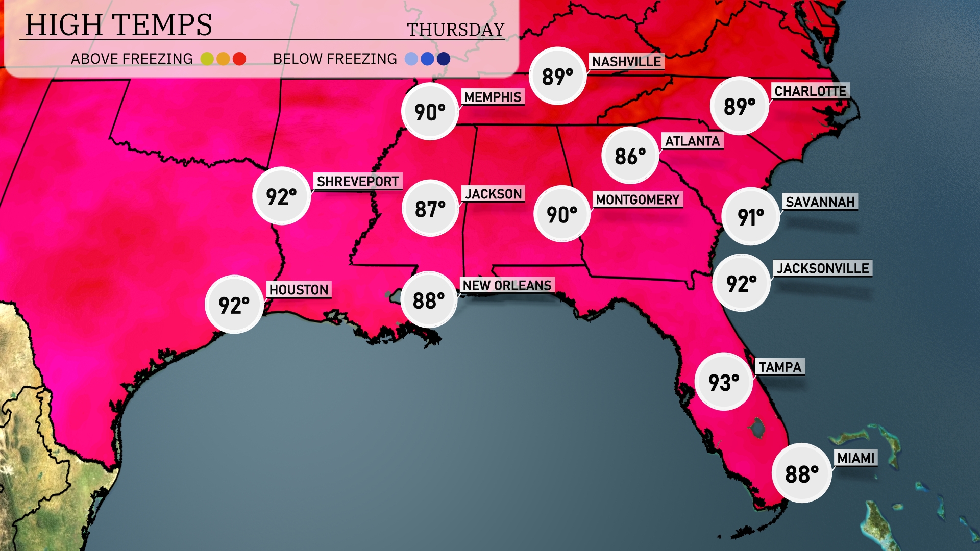
Tomorrow in the Southeast, temperatures soar with high readings across the region. Atlanta will peak at a warm 90 degrees, while Jacksonville and Houston match that at 92. Montgomery is set for a high of 90 degrees, with Savannah slightly cooler at 91. The Gulf states remain toasty, with New Orleans reaching 88 and Shreveport hitting 92. Expect above-average temperatures as a warm front influences the area, keeping conditions steamy.
A series of thunderstorms is forecasted to sweep across the Southeast from Montgomery to Charlotte by tomorrow afternoon, with rain showers extending from Jacksonville to Savannah. The storms could bring gusty winds and heavy downpours, so stay alert for potential severe weather warnings, particularly around Atlanta by midday. There’s an anticipated drop in temperatures following the front, with cooler, drier air filtering in by Thursday. Precipitation totals could be significant, posing a risk of localized flooding in low-lying areas. Be prepared for shifting weather conditions as a cold front moves through the region.
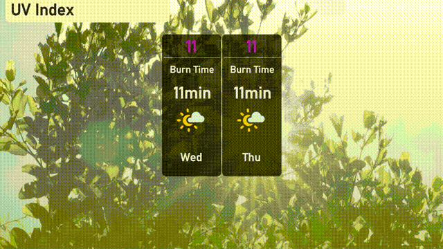
In Miami, the UV index will soar to a very high level of 11 on both Wednesday and Thursday, with a burn time as short as 11 minutes under direct sunlight. Sunscreen, sunglasses, and protective clothing are a must if you’re heading outdoors to enjoy the sunshine!