Miami’s Weekly Weather Rollercoaster: Sun, Clouds, and Storms
By
Amy Freeze
Explore Miami's dynamic weather from August 8th to 13th, 2025, featuring everything from sunny skies to potential thunderstorms. Stay prepared with our comprehensive forecast.
Dive into our comprehensive guide on Miami’s weather for the week of August 8th to 13th, 2025—from sun-filled mornings to stormy evenings. Be sure to follow our daily updates and tips to stay weather-wise!
Starting the second week of August with a mix of partly sunny skies and occasional storms, Miami’s weather is set for variety. Expect temperatures to hover around the 80s, with brief showers and possible thunderstorms particularly from mid to late week as a cold front approaches. Daily UV index levels are high, making sunscreen a must. Our extended forecast details each day’s weather, ensuring you’re fully prepared whether you’re planning to hit the beach or navigate rain-soaked streets. Keep an eye on our updates and remain safe during fluctuating weather conditions.
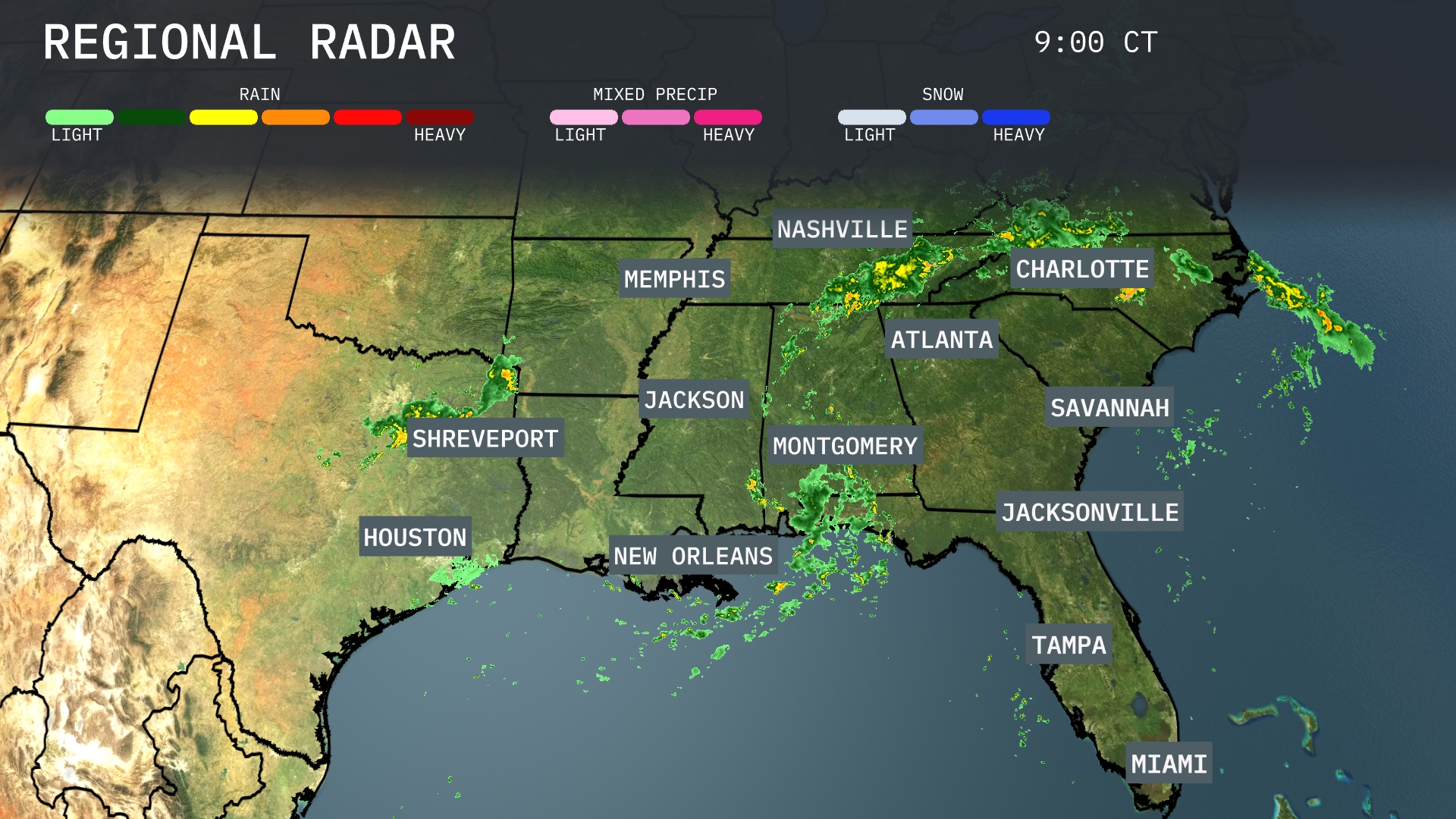
On the Regional Radar, rain showers are moving through southeastern Louisiana towards New Orleans. This storm system is advancing eastward, bringing increased cloud cover and rain over the Mississippi Gulf Coast. Northern Georgia and the Carolinas are experiencing widespread showers and storms, with heavy rain approaching Charlotte and Atlanta. The weather remains relatively calm across Memphis and Nashville, though cloud cover is increasing.
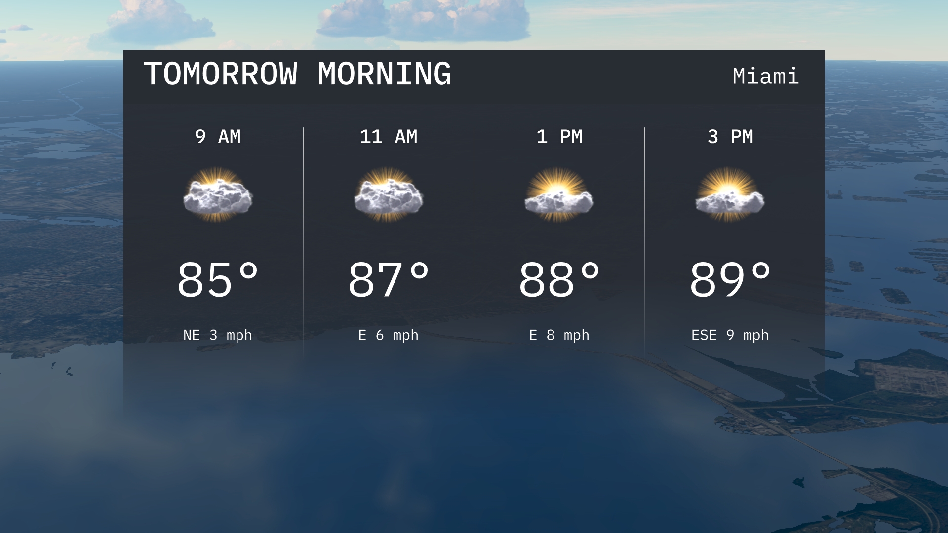
Miami tomorrow morning starts off warm at 85 degrees by 9 AM with mostly cloudy skies. Temperatures will rise to 87 degrees by 11 AM as clouds continue to linger. Expect easterly winds.
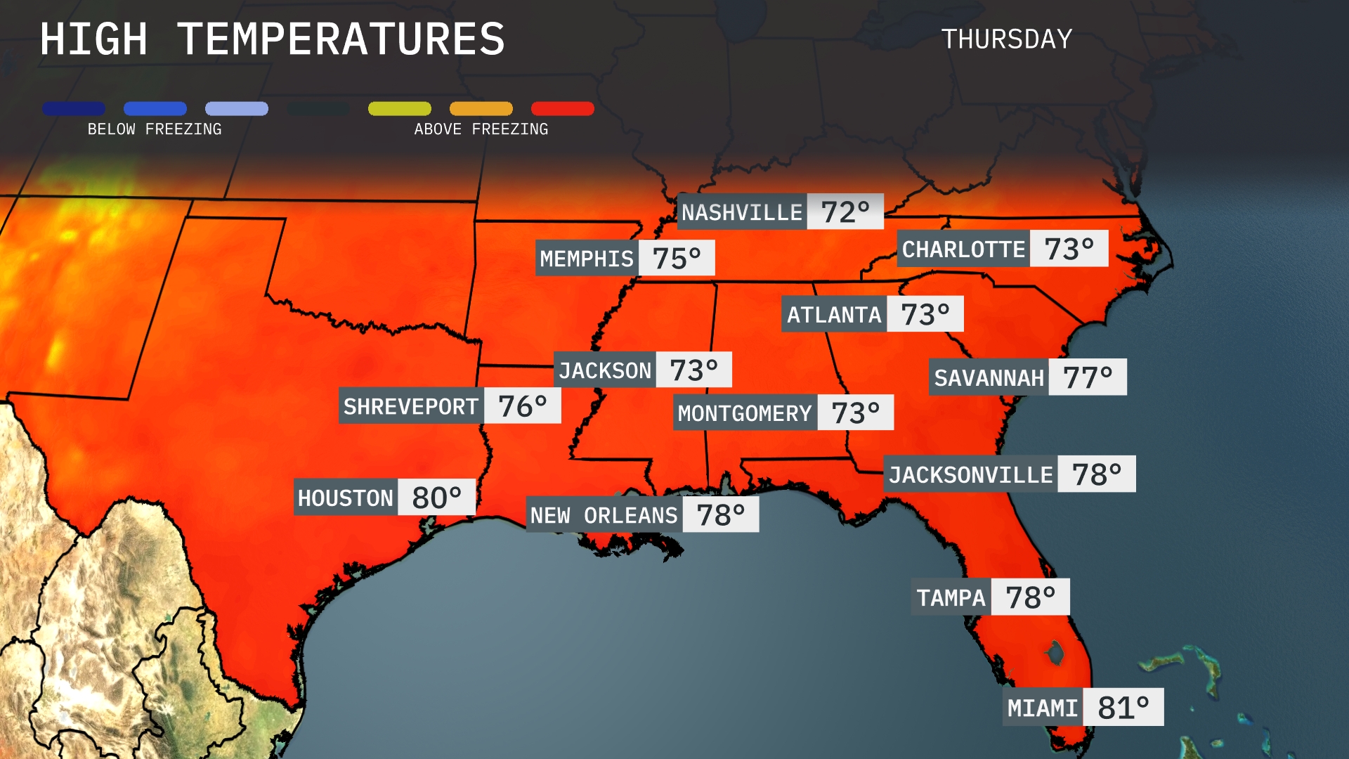
Tomorrow in the Southeast, Miami is looking at a warm high of 81 degrees. Atlanta can expect a pleasant 73, while Nashville will see a slightly cooler 72 degrees. Savannah will warm up to 77, and New Orleans is forecasted for 78 degrees. Most cities are experiencing temperatures around average for this time of year, influenced by a ridge of high pressure moving through the region.
A slow-moving cold front will bring thunderstorms across Southeast tomorrow. Expect storms to extend from Jackson through Memphis and into Nashville, with heavy downpours likely to impact the morning commute. By the afternoon, the storm trajectory will shift toward Atlanta and Charlotte, with the potential for isolated severe storms. Jacksonville and parts of southern Georgia could experience late-day showers. Temperatures will be slightly cooler post-frontal passage, but humidity remains high.
Miami’s UV index is at a high of 8 today, with a burn time of just 11 minutes, so sunscreen and protective gear are crucial! Tomorrow will have similar intensity, maintaining that high level with the same short exposure time of 11 minutes.
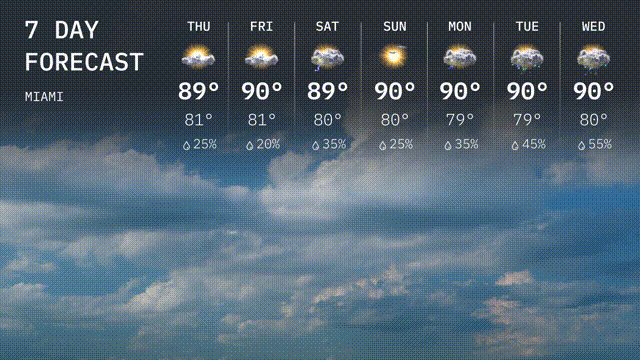
Thursday: Anticipate partly cloudy skies with a high of 89 degrees and a low of 81 degrees.
Friday: Look for a warm day with a high reaching 90 degrees. The night will cool down slightly to 81 degrees, with a chance of rain.
Saturday: The weekend begins with a high of 89 degrees under partly sunny skies, cooling to 80 degrees at night. Expect a chance of rain.
Sunday: Sunny weather is on the menu with temperatures rising to 90 degrees and dipping to 80 degrees after sunset. Rain will be isolated.
Monday: The new week kicks off with mostly sunny skies, a daytime high of 90 degrees, and a low of 79 degrees at night. There’s a chance of rain.
Tuesday: Similar conditions persist with a high of 90 degrees, a low of 79 degrees, and a rain chance.
Wednesday: The week continues with a high of 90 degrees and lows around 80 degrees as clouds and showers are more likely with a chance of rain.