From Storms to Sunshine: Navigating April’s Dynamic Midwest Weather
By
Amy Freeze
Explore the varied weather patterns sweeping through the Midwest, from intense thunderstorms to surprising sunny spots. Unlock the details in our full coverage!
Catch the latest weather trends in the Midwest, featuring meteorologist Amy Freeze. From storm warnings to gentle sun, prepare for a week of varied climates.
This week, the Midwest is experiencing a whirlwind of weather patterns. Follow Meteorologist Amy Freeze as she guides you through each day’s forecast, from snowy evenings to thunderous mornings, ensuring you’re well-prepared no matter the weather. Detailed insights, safety tips, and weather forecasts are packed in our comprehensive guide. Read more at https://amyfreeze.ai/
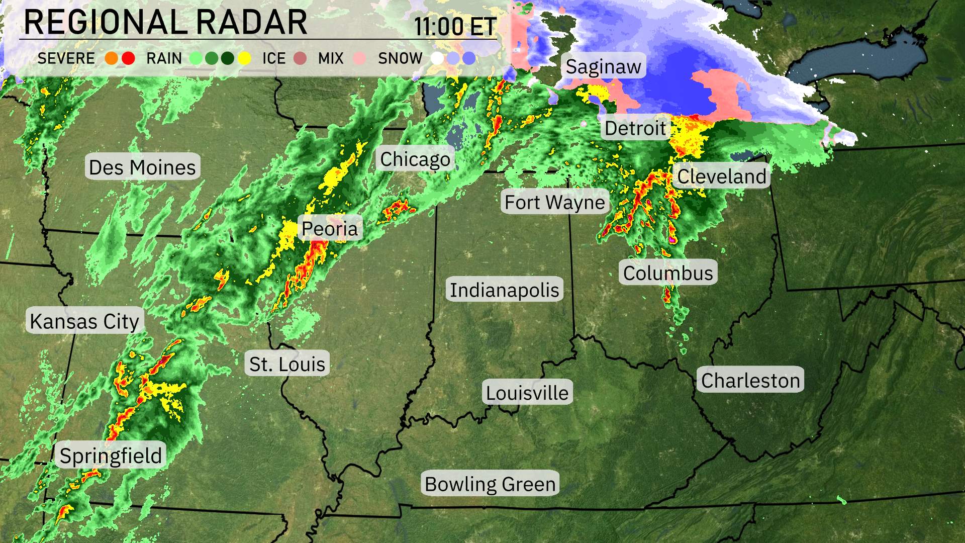
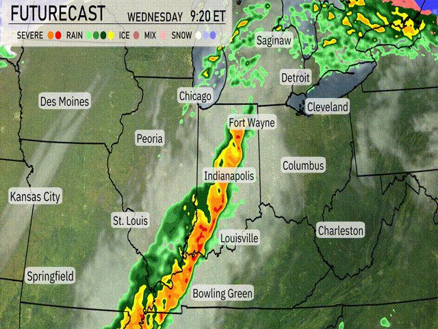
A line of storms is sweeping across the Midwest, moving from Des Moines toward Peoria, bringing with them bouts of heavy rain. Springfield is seeing these showers push through, while St. Louis has already experienced the brunt of the initial wave. Up around Chicago, the rains are intensifying as they travel east, and Indianapolis is on track for a wet afternoon as the system presses onward.
Further north, around Fort Wayne and Detroit, severe weather is shaking things up, with potential for thunderstorms. Saginaw is getting a snow mix, hinting at a chillier atmosphere and perhaps some slick conditions on roads. Cleveland’s radar shows a mix of rain and ice, suggesting a messy commute ahead. Down south a bit, Columbus is somewhat dry at this moment but will need to brace for incoming showers moving in.
Charleston stays clear for now, though clouds are likely to build. Meanwhile, Bowling Green is seeing some isolated rain patches, likely to pass quickly. So, Midwest folks, keep your umbrellas ready and eyes on the skies as this dynamic weather pattern makes its way across the region.
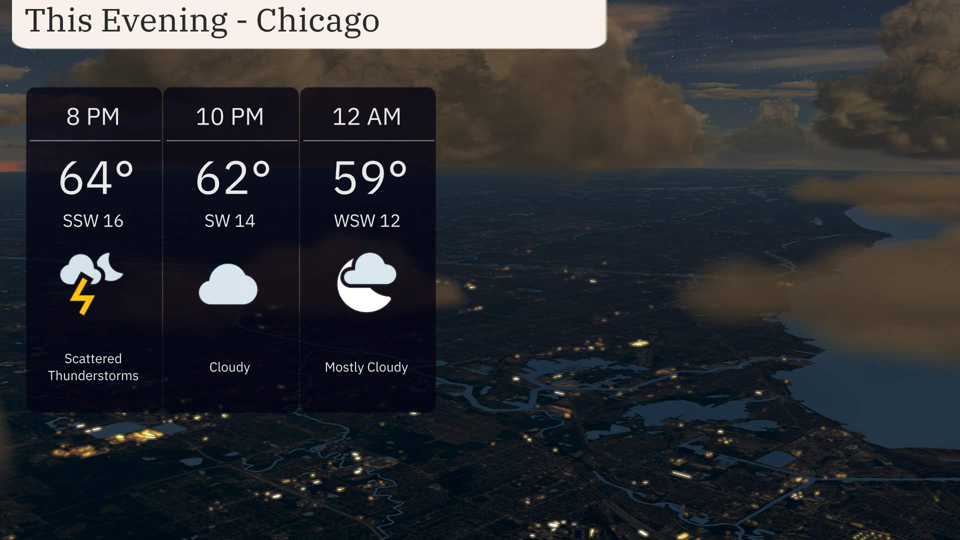
This evening in Chicago, anticipate scattered thunderstorms initially, with temperatures beginning at 64 degrees around 8 PM. Winds will be from the south-southwest at 16 miles per hour, transitioning to a more calm and cloudy night. By 10 PM, temperatures will dip to 62 degrees under cloud cover, with winds decreasing to 14 miles per hour. Heading towards midnight, expect mostly cloudy skies and temperatures at 59 degrees, with winds shifting to the west-southwest at 12 miles per hour.
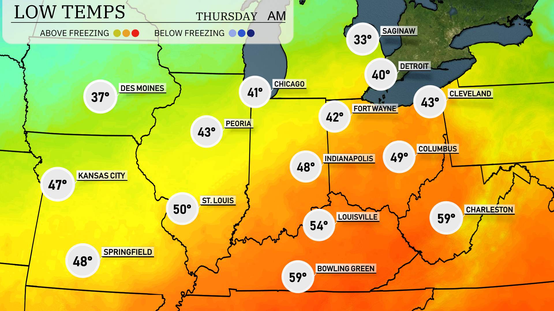
Tonight Des Moines will drop to 37, while Kansas City sees a slightly milder night with a low of 47. St. Louis will cool down to 50.
Farther to the east, Indianapolis registers a low of 48 degrees, and Fort Wayne is forecasted to drop down to 42. In Ohio, Columbus will see a low of 49.
Saginaw faced a significant drop, with temperatures plunging to 33 degrees.
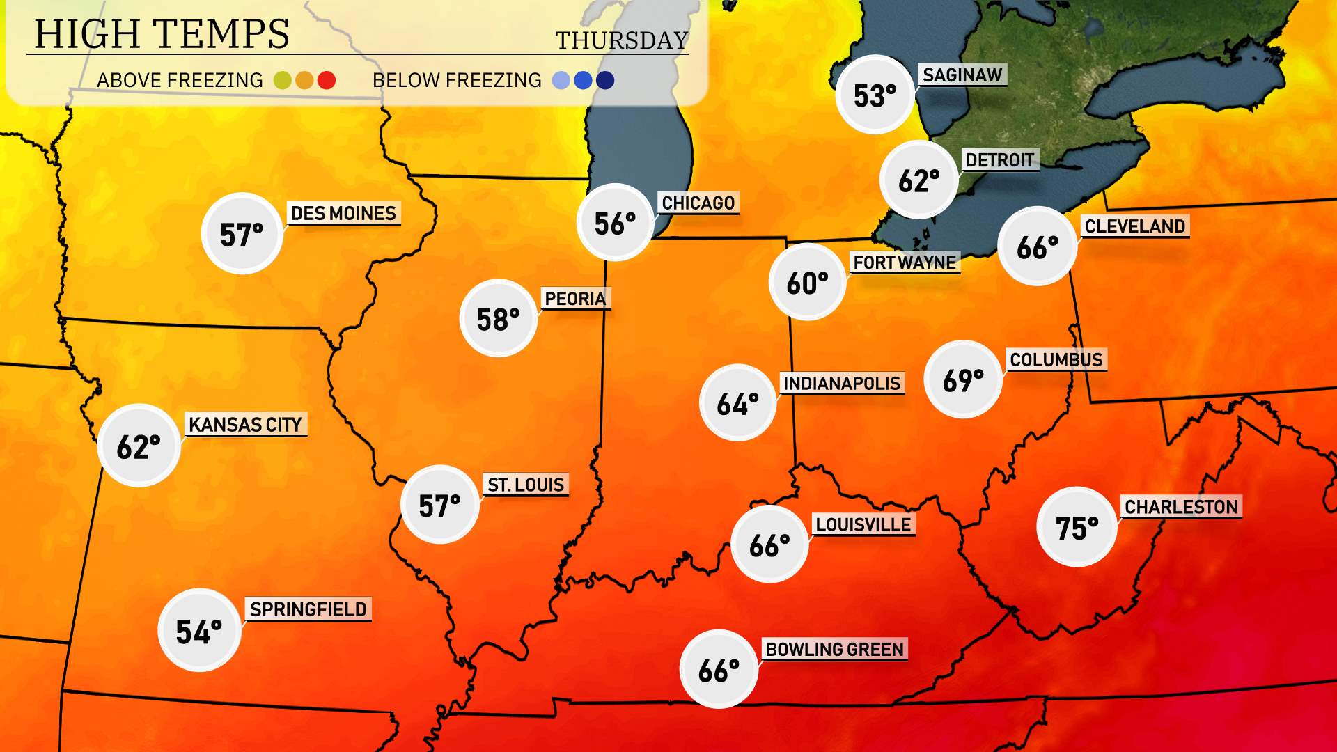
Tomorrow, the Midwest region will see a range of high temperatures, continuing a trend of slightly above-average readings for early April.
In Chicago, expect a high of 56 degrees, while Peoria will reach 58 degrees. St. Louis is slightly warmer, with a high of 57 degrees. Indianapolis anticipates a comfortable 64 degrees, and just south in Louisville, temperatures rise to 66 degrees.
Heading east, Columbus could hit a high of 69 degrees, while Cleveland is forecasted to reach 66 degrees. The warmest spot will be Charleston, West Virginia, soaring to 75 degrees.
An overarching pattern of high pressure is keeping skies mostly clear, allowing temperatures to rise.
A strong line of thunderstorms is expected to sweep through the Midwest on Wednesday. Severe weather possibilities include damaging winds and potential short-lived tornadoes, particularly from Fort Wayne down through Indianapolis and into Louisville. The northern edge near Detroit and Chicago will see moderate rain by late evening. Areas like Cleveland can expect heavy showers overnight. Flooding could become a concern in urban areas as the fronts push eastward. Temperatures ahead of the storm remain mild but will drop significantly after the passage of the cold front. Stay alert for any weather warnings in the next 24 to 48 hours.
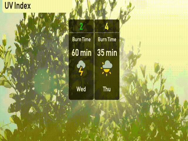
Expect a low UV index of 2 in Chicago today due to cloudy skies with storms, reducing sun exposure. There’s no significant risk of sunburn. Tomorrow, the UV index increases to ust 4.
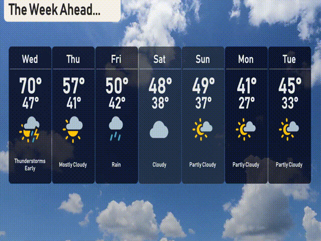
For the 7-day forecast in Chicago:
Wednesday: Thunderstorms expected early with a high of 70 degrees and a low of 47.
Thursday: Mostly cloudy skies, temperatures will reach 57 degrees and dip to 41 at night.
Friday: Rain showers throughout the day with a high of 50 degrees, cooling to 42.
Saturday: Cloudy conditions persist, with temperatures peaking at 48 degrees and a low of 38.
Sunday: Partly cloudy skies with a high of 49 degrees and a low of 37.
Monday: Partly cloudy, cooler temperatures with a high of 41 degrees and a low of 27.
Tuesday: Partly cloudy once more with a high of 45 degrees and an overnight low of 33.