Midwest Weather Mosaic: From Sunny Days to Stormy Nights
By
Amy Freeze
Experience the diverse spring weather patterns across the Midwest, from balmy Kansas City to rainy Louisville. Amy Freeze breaks down this week's weather intricacies with precision.
Dive into the myriad of temperatures and weather conditions this spring in the Midwest. From calm, sunny days to unexpected thunderstorms, stay prepared with Amy Freeze’s detailed updates.
Spring in the Midwest brings a colorful palette of weather conditions. Follow along as Amy Freeze, renowned meteorologist, guides you through each city’s forecast, highlighting expected temperatures, weather anomalies, and safety tips. From Chicago’s brisk winds to Kansas City’s warm embrace, prepare for the week with effective strategies to enjoy or combat diverse weather scenarios. Read our full blog post for in-depth analysis and tips: https://amyfreeze.ai/midwest-weather-forecast
From Chicago to Indianapolis and extending northeastward to Cleveland and Detroit, the Midwest is enjoying relatively clear skies, offering a pleasant break from recent weather activity. However, attention turns towards the south where Bowling Green and Louisville are currently under rainy skies. This rain extends farther eastward, covering much of Charleston in West Virginia.
The storm system in the region continues to feed moisture from the southwest, with light to moderate rainfall affecting areas stretching from Peoria down through St. Louis. Springfield is seeing cloud cover but remains mostly dry at this time.
Meanwhile, Des Moines and Kansas City lie comfortably under a clearer pattern, with only a slight chance of scattered clouds throughout the day. As we venture to the northeast, Saginaw remains calm, enjoying a reprieve from any immediate precipitation.
This afternoon in Chicago, temperatures are expected to hover in the 40s, cooling slightly from 47 degrees at 4 PM to 44 degrees by 8 PM. Throughout the afternoon, look for sunny skies with winds coming from the north-northeast at 10 miles per hour, shifting to east-northeast at 5 miles per hour by the evening, maintaining a calm and bright atmosphere.
Kansas City is warming up nicely with a high of 66 degrees, making it one of the warmest spots in the region. St. Louis follows closely at 56 degrees, while Springfield hits 62.
In Illinois, Peoria will reach a high of 56 degrees, and Chicago is on the cooler side with just 47 degrees. Over in Indiana, Indianapolis has a high of 51, while Fort Wayne is also slightly warmer at 50 degrees.
Heading to Ohio, Cleveland is much chillier with a high of only 42 degrees, a significant contrast to the southern parts of the Midwest. Today’s weather showcases a striking range in temperatures as we transition into spring!
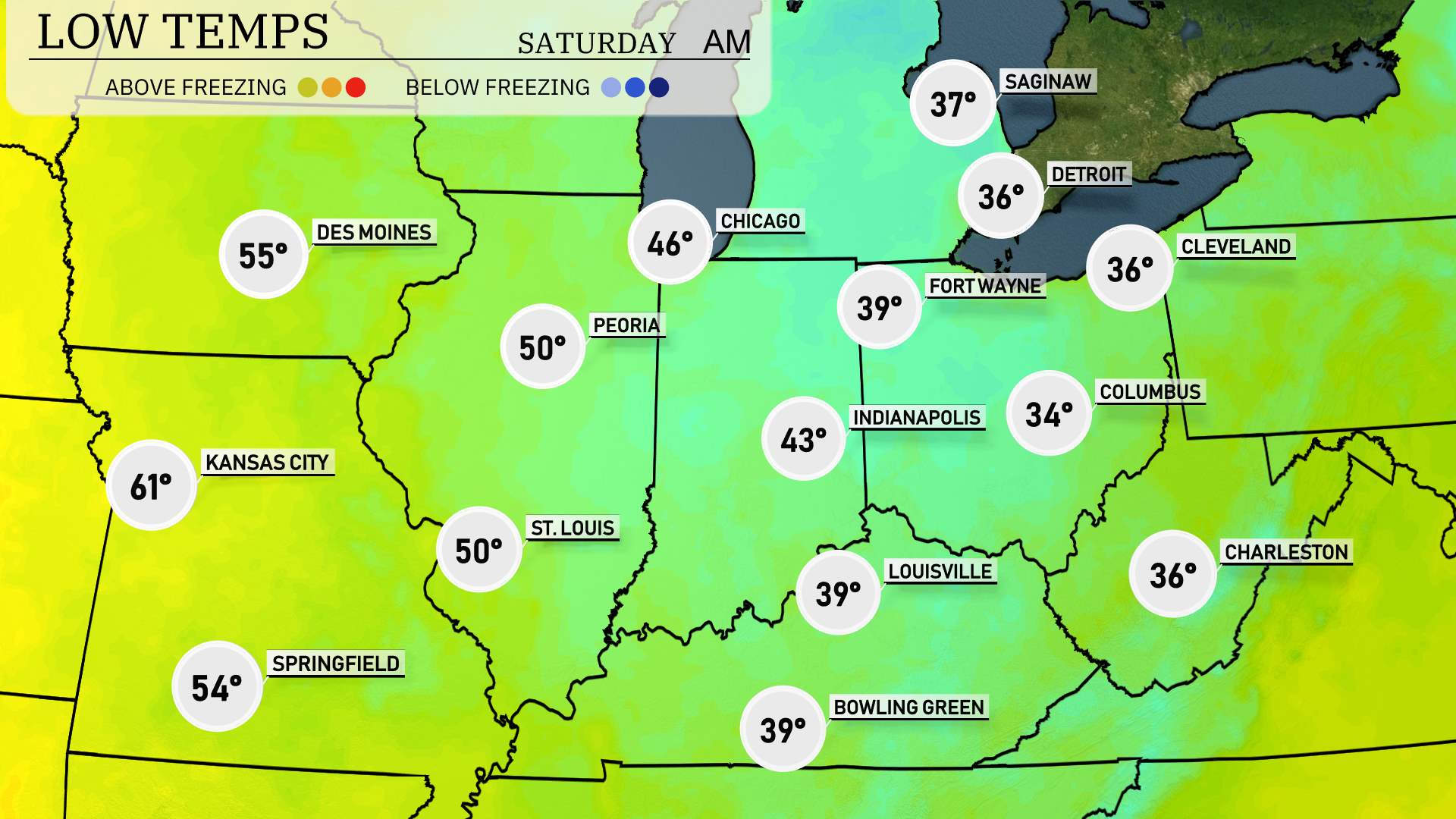
Chicago will cool down to around 39 degrees, while Fort Wayne dips to 36. Indianapolis will see a low of 34, making for a brisk night. Louisville isn’t far behind at 39 degrees, and both St. Louis and Peoria will settle at 50. Farther north, Des Moines will report a mild 55.
High temperatures across the Midwest for tomorrow show a significant warm-up, with many areas experiencing above-average temperatures for this time of year.
In Kansas City, expect a notable high of 79 degrees, significantly above average for this time of year. Springfield will also warm up to 73 degrees. Further east, St. Louis is looking at a comfortable high of 65 degrees, while Peoria reaches 64 degrees.
Moving north, Des Moines will see highs around 72 degrees, and Chicago is predicted to peak at 57 degrees. Indianapolis will experience a high of 61 degrees, while Louisville will have temperatures reaching 62 degrees.
Trends include warmer-than-normal conditions across much of the region, influenced by an influx of warm air from the south.
A cold front moving through the Midwest will bring notable changes. Starting late Friday, anticipate scattered showers from Fort Wayne to Cleveland, with possible thunderstorms closer to Indianapolis. As the front pushes eastward, expect cooler temperatures to settle in by Saturday, particularly around Chicago and St. Louis, with highs dropping into the 50s. Meanwhile, farther south in areas like Louisville, expect localized heavy rain with potential flash flooding. Winds will shift to the northwest, bringing drier conditions by Saturday afternoon, clearing skies from west to east across the region. Stay aware of any severe weather alerts as the system progresses.
In Chicago, the UV index will be moderate at 6 for both Friday and Saturday. Expect a burn time of about 23 minutes in direct sunlight.