Midwest Weather Alert: From Thunderstorms to Sunshine!
By
Amy Freeze
Dive into an in-depth forecast with Amy Freeze as she covers the dynamic Midwest weather, from thunderstorms rolling through St. Louis to sunny forecasts in Chicago.
Experiencing the Midwest’s whimsical weather? From chilly evenings to thunderous warnings, Amy Freeze guides you through a week of diverse weather patterns!
Meteorologist Amy Freeze brings you the latest on the Midwest’s weather dynamics, tracking everything from tonight’s cloudy prospects in Chicago to the anticipated rain showers and rising temperatures later this week. Discover how these conditions could affect your plans and get pro tips on staying prepared. For more insights, follow the link: https://amyfreeze.ai/
A cluster of intense thunderstorms is moving eastward across central Missouri, with particularly strong activity near St. Louis. This area is experiencing heavy rain and storms extending northwards towards Peoria, Illinois. The rain is expanding eastward, bringing showers into Springfield and approaching the western edge of Indianapolis. Farther north, cloud cover is increasing around Chicago, but conditions remain dry for now.
For this evening in Chicago, expect cloudy skies with temperatures holding steady around 60 degrees at 9 PM, slightly cooling to 59 degrees by 11 PM, continuing through 1 AM. Winds will be breezy from the south-southeast at 18 miles per hour, shifting slightly to the south at 17 miles per hour later in the evening.
Tonight in the Midwest, temperatures will dip significantly. Chicago will see a low of 46 degrees, while Des Moines cools down to 39 degrees. Kansas City will experience a milder night at 46 degrees. St. Louis is forecasted for a low of 55, but travelers to Indianapolis should prepare for 63 degrees. Expect lows in the 60s in southern cities like Louisville at 68 and Bowling Green at a warm 70 degrees.
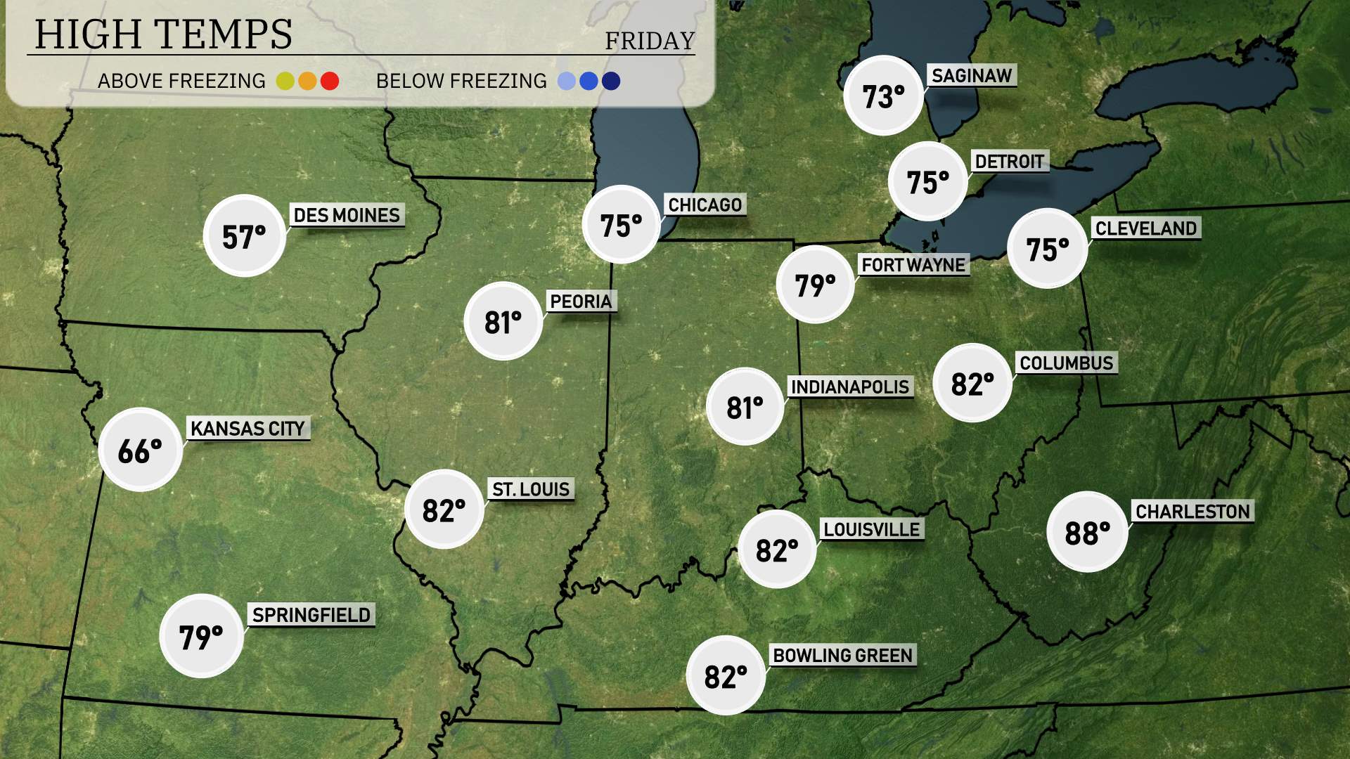
High temperatures across the Midwest tomorrow will be notably warm, with many areas hitting above-average readings. In Chicago, expect a high of 75 degrees, while Indianapolis warms up to a pleasant 81. Louisville and Bowling Green should both reach 82 degrees, and Fort Wayne isn’t far behind at 79. In contrast, Des Moines will be cooler at just 57 degrees, emphasizing a significant temperature gradient across the region.
Expect a busy weather day across the Midwest tomorrow as a cold front approaches. Rain showers will move from Des Moines early in the morning, reaching Chicago by midday and pushing towards Fort Wayne by late afternoon. There could be scattered thunderstorms, particularly around Indianapolis and Columbus, though severe storms are unlikely.
In Chicago, expect a UV index of 3 on Thursday, alongside stormy conditions that will keep sun exposure minimal. On Friday, sunny skies with a UV index of 5 suggest a burn time of approximately 27 minutes.
Thursday: The day kicks off with cloudy skies, reaching a high of 67 degrees and a low of 58 degrees.
Friday: Expect thunderstorms with temperatures climbing to 77 degrees, then dropping to 48 degrees.
Saturday: The weather turns cloudy again, with a high hitting 55 degrees and a cooler low of 45 degrees.
Sunday: Rainy conditions dominate, with the thermometer showing a high of 52 degrees and an overnight low of 51 degrees.
Monday: Partly cloudy skies greet us with a daytime high of 56 degrees and a low of 43 degrees.
Tuesday: More clouds but milder conditions, highs expected around 63 degrees and lows at 53 degrees at night.
Wednesday: We wrap up the week with mostly cloudy skies and temperatures peaking at 70 degrees and dropping to 49 degrees.
Stay prepared and enjoy your week!