Midwest Weather Alert: Navigating Through Rain, Snow, and Sun!
By
Amy Freeze
Explore the latest forecasts as Meteorologist Amy Freeze guides us through a tumultuous weather weekend across the Midwest. From chilly showers to unexpected snowfall, know what's headed your way.
This weekend, the Midwest faces a rollercoaster of weather conditions. Meteorologist Amy Freeze highlights what to expect and how to prepare for rain, snow, and sun.
As the Midwest braces for a complex weather system, Amy Freeze provides an insightful analysis into the coming days. Expect varied conditions ranging from severe storms in southern regions to wintry mixes in the north. This detailed post delves into each day’s forecast, ensuring residents and visitors are well-prepared for what’s ahead. With safety tips and expected temperature changes, stay ahead of the weather with Amy’s expert guidance.
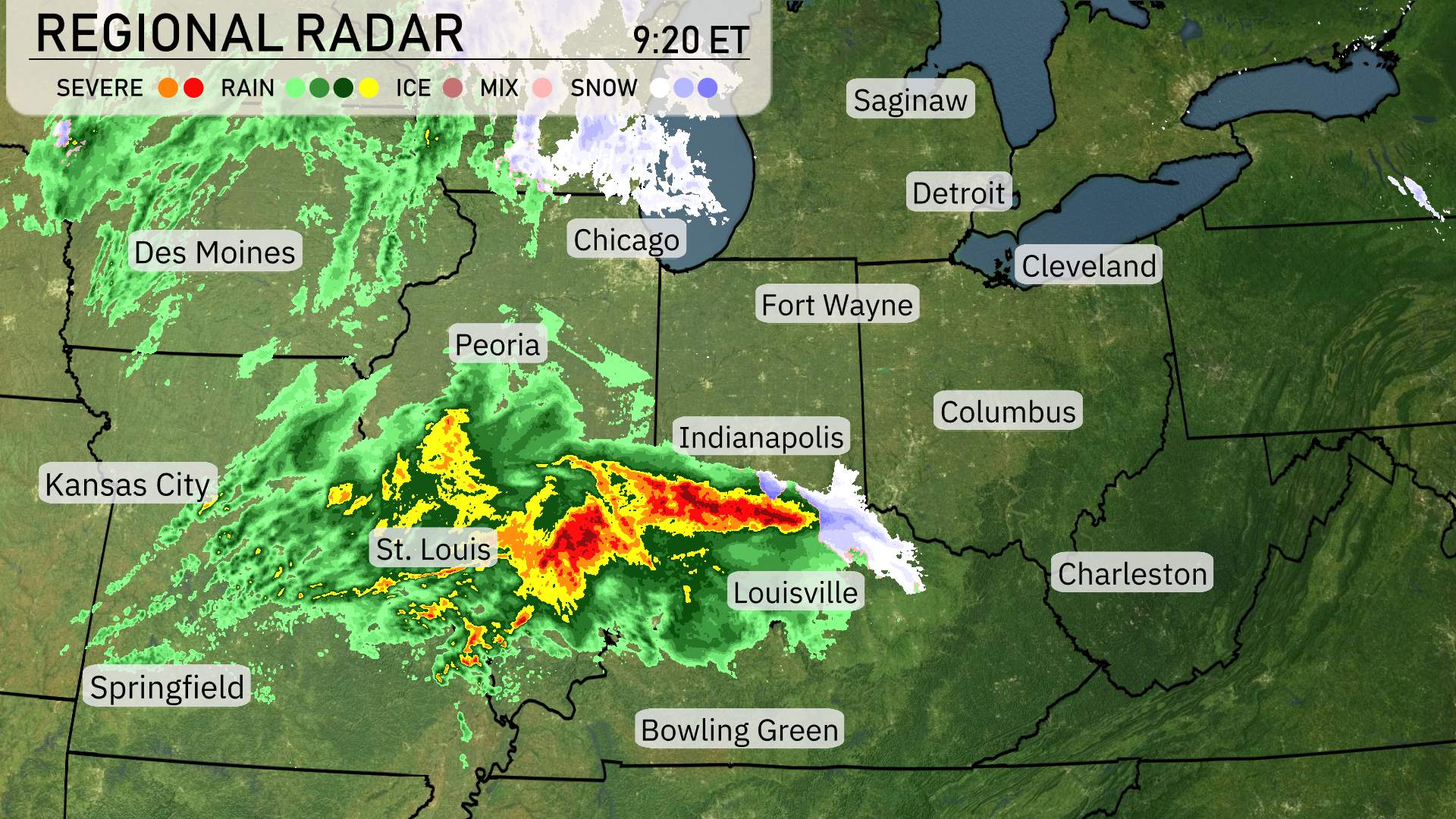
On the regional radar, a dynamic weather pattern is unfolding across the Midwest. A robust storm system stretches from St. Louis eastward, bringing intense rain and severe weather. The heaviest activity can be seen as a dense area of storms moving towards Indianapolis and Louisville, with strong precipitation expected in these regions.
To the north, Chicago is under cloudy skies, with showers beginning to impact the area as the day progresses. For folks in Peoria, expect a rainy morning as the system passes through, with clearing conditions anticipated later in the day.
Farther north, from Detroit to Cleveland, current conditions are dry but cloud cover is increasing as the system draws near. Look for conditions to evolve with showers expected later. Fort Wayne and Columbus remain relatively calm but may experience some precipitation as the storm edges closer.
To the northeast, in places like Saginaw, conditions remain clear for now, but you’re not out of the woods yet, as the system is expected to potentially bring rain later. Lastly, Bowling Green is experiencing a mix of snow as cooler air interacts with the moisture, creating a potential for wintry conditions.
Afternoon temperatures in Chicago are steady, hovering around 46 degrees with wind conditions shifting throughout the afternoon. A southeast breeze at 12 miles per hour brings in light rain by 3 PM. The rain lingers, transitioning to a southwest wind at 15 miles per hour by 5 PM. As we move farther into the evening, expect cloudy skies with winds coming from the west-southwest at 18 miles per hour.
Let’s take a look at today’s high temperatures across the Midwest. It’s a mild day in St. Louis, reaching a high of 64 degrees, while Kansas City warms to 62 degrees this afternoon. Springfield is even warmer, hitting 67 degrees.
Moving to the northern areas, iIn Chicago, temperatures are a bit cooler at 46 degrees. Farther east, Indianapolis and Columbus are both sitting at 47 degrees, while Fort Wayne is just slightly cooler at 43 degrees.
Expect a chilly drop as a cold air mass settles in. Chicago is down to 33 degrees. Further south, Indianapolis will experience a low of 36, while Fort Wayne drops to 29, entering freezing territory. In St. Louis, it will be 42 degrees, and Kansas City will see a low of 42 as well. Peoria will hit 38. Columbus is expected to be cool at 33 degrees.
High temperatures across the Midwest tomorrow are shaping up to be notably mild, with several cities experiencing above-average readings.
In Chicago, expect a high of 49 degrees, while Indianapolis will see temperatures reach 55 degrees. St. Louis is projected to warm up to 61 degrees, and Kansas City is anticipating a comfortable 63 degrees.
Farther south, Bowling Green should enjoy a warm high of 66 degrees, and Charleston clocks in at 65 degrees.
“The Midwest is in for an active weather pattern as a cold front advances. Tomorrow, expect widespread rain beginning early in the day, stretching from St. Louis to Cleveland. Areas around Detroit and Chicago could experience a wintry mix as temperatures hover close to freezing. Strong thunderstorms are possible farther south, affecting Louisville and Bowling Green, with a risk of damaging winds. Temperatures will drop significantly behind the front, leading to more mild and cooler conditions late in the day and into Monday. Be alert for weather warnings as conditions unfold.”
The UV index in Chicago is low today with a value of 2, primarily due to the storm system blocking harmful rays, so sun exposure risks are minimal. However, expect a moderate UV index of 5 on Monday with a burn time of about 27 minutes in direct sunlight.