Midwest Mosaic: A Tapestry of Temperatures, Storms, and Snow
By
Amy Freeze
Meteorologist Amy Freeze provides an in-depth look at the fluctuating weather patterns across the Midwest, from serene skies in Chicago to stormy surprises in Indianapolis.
From frosted evenings in Chicago to wet warnings in Indiana, Amy Freeze’s latest forecast covers the broad spectrum of climatic shifts in the Midwest. Tune in for daily temperature trends and safety tips!
This week’s weather across the Midwest comes with a bag of surprises, as detailed by meteorologist Amy Freeze. With partly cloudy skies in Chicago and storms brewing over Indiana, the region witnesses varied climatic conditions. The cooling trend in Chicago brings chilly vibes, while southern Illinois experiences moderate rainfall. As temperatures take a nightly dip, residents are advised to stay prepared for sharper chills. Follow this comprehensive guide to navigate through fluctuating temperatures and storm alerts efficiently.
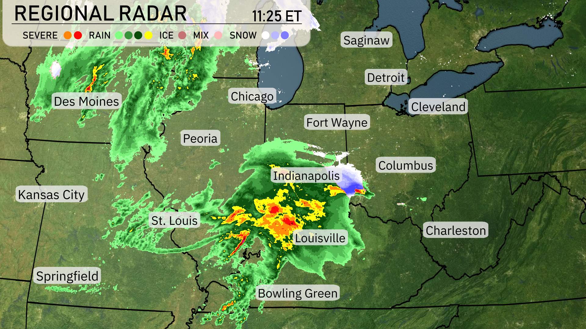
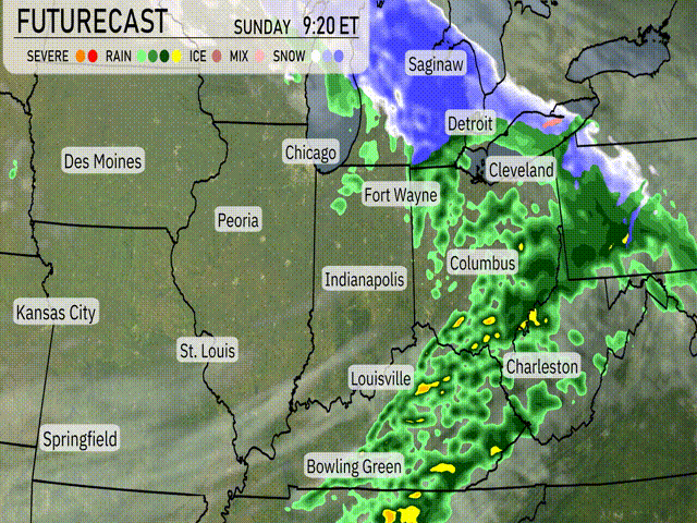
The Midwest region is abuzz with weather activity today, showcasing a mix of severe storms, rain, and even patches of snow. A strong storm line is pushing across Indiana and Kentucky, with Indianapolis and Louisville experiencing intense rainfall and thunderstorms. This weather system is making its way eastward, so areas like Columbus should prepare for heavy rainfalls shortly. Meanwhile, Fort Wayne is already getting some rain but should brace for heavier rain as the system advances.
Detroit and Cleveland are currently under cloud cover, but nothing severe for now. St. Louis experiences light rain and cloudy skies. Southern parts of Illinois, including Bowling Green, are dealing with moderate rainfall. The northern regions such as Chicago and beyond up to the Great Lakes are relatively calm.
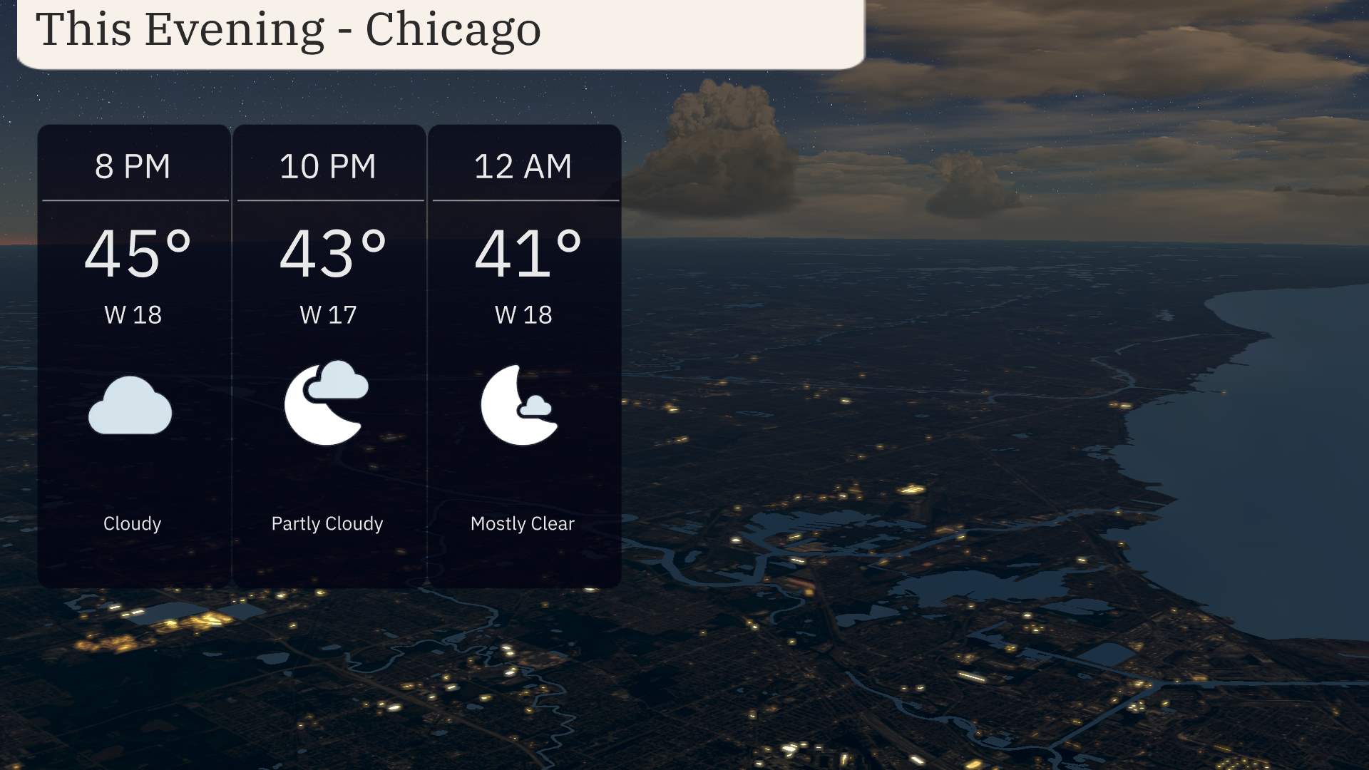
For this evening in Chicago, a cooling trend is expected as temperatures dip from 45 degrees at 8 PM to 41 degrees by midnight. Winds from the west at 17-18 miles per hour will keep a chill in the air.
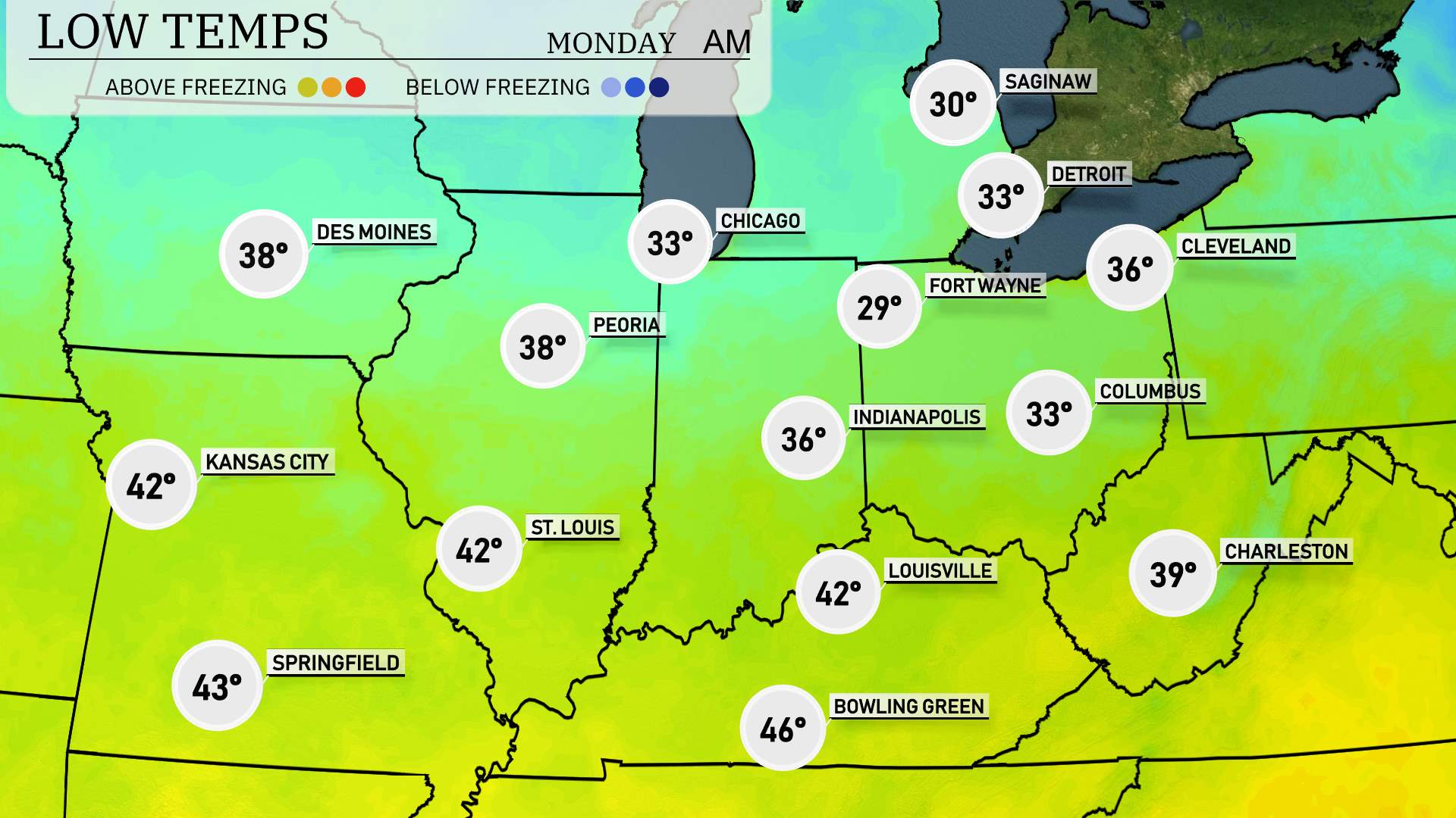
Tonight’s weather will bring a sharp cooldown across the Midwest. Expect a freeze in key cities as colder air settles in. Chicago is looking at a low of 33 degrees. Indianapolis will dip to 29, while Fort Wayne also reaches 29 degrees. In Ohio, Cleveland has a forecast low of 36. Moving south, St. Louis will see a low of 42 degrees, and Kansas City will stay slightly warmer at 42 as well. Peoria is forecasted to drop to 38 degrees.
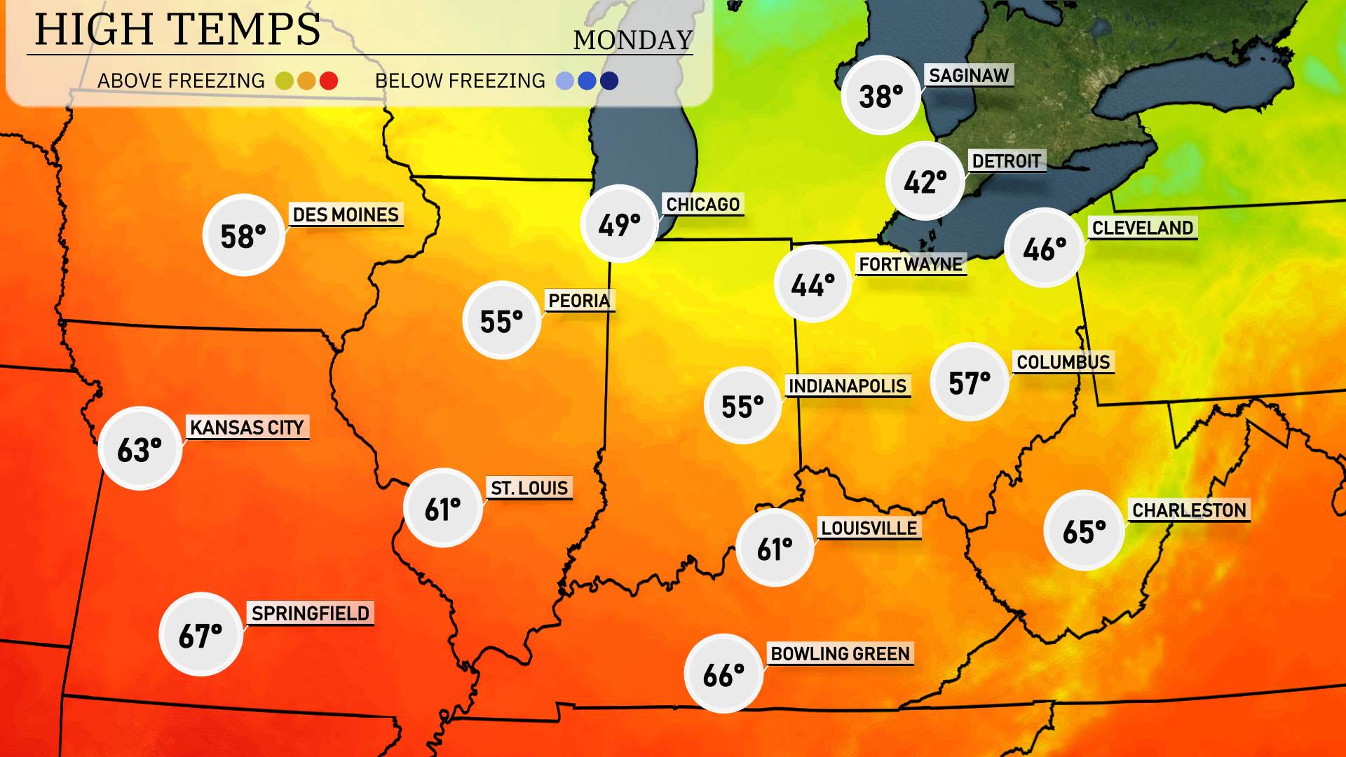
High temperatures tomorrow across the Midwest are shaping up to be quite varied.
In the northern states, Chicago will see a high of 49 degrees, while further north in Saginaw, Michigan, temperatures will only reach around 38 degrees. Fort Wayne, Indiana is expected to hit 44 degrees, slightly below average for this time of year.
Moving south, Kansas City is looking at a more mild day with a high of 63 degrees. St. Louis will come in at 61 degrees, and Peoria, Illinois is expected to hit 55 degrees. Louisville also matches that at 61 degrees, while further southeast, Charleston, West Virginia, will warm up nicely to 65 degrees.
“A cold front is set to bring impactful weather across the Midwest tomorrow. Expect heavy rain showers and embedded thunderstorms, especially from Louisville to Columbus. There’s a potential for localized flooding with the heavy downpours, so stay cautious on the roads. Farther north, areas from Detroit to Saginaw could see some light snow mixing with rain, creating slick conditions. Temperatures will drop in the wake of the front with a shift to more chilly conditions on Sunday, as cooler air moves in behind the system.”
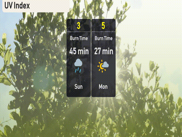
The UV index in Chicago is low today due to cloud cover and occasional storms, effectively reducing harmful sun exposure. Tomorrow, the UV index will be moderate at 5, with a burn time of about 27 minutes. Remember to apply sunscreen and seek shade, especially during midday hours!
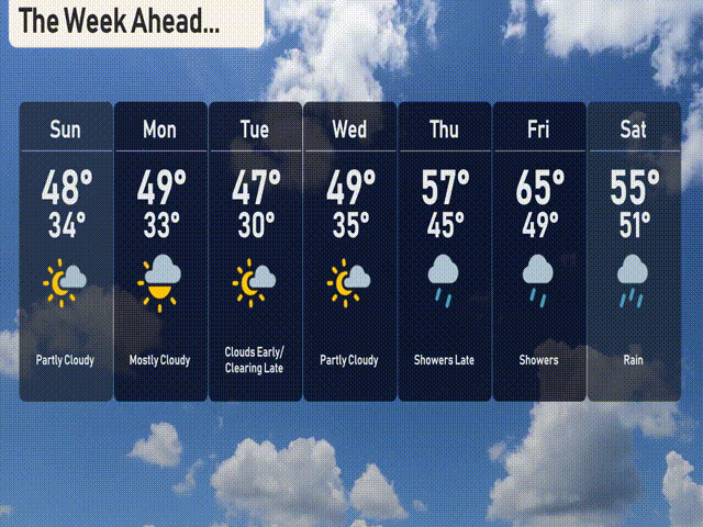
For the 7 Day Outlook in Chicago:
Sunday: Anticipate partly cloudy skies with a high of 48 degrees and a low of 34 degrees.
Monday: Mostly cloudy weather persists, with the temperature reaching up to 49 degrees during the day and dropping to 33 degrees at night.
Tuesday: Expect clouds early, clearing as the day progresses. The high will be 47 degrees, with a nighttime low of 30.
Wednesday: Partly cloudy conditions with highs of 49 degrees and lows around 35.
Thursday: Showers are expected late in the day, with temperatures climbing to 57 degrees and descending to 45 degrees overnight.
Friday: Expect rain throughout the day, as the high reaches 65 degrees and the low falls to 49 degrees.
Saturday: Rain continues, with a high of 55 degrees and a low of 51.