April’s Atmospheric Antics: Snow, Rain, and Sun Across the Midwest
By
Amy Freeze
Explore the lively mix of weather patterns hitting the Midwest this April, from unexpected snowfalls to refreshing sunny breaks, with insights from renowned Meteorologist Amy Freeze.
Catch up on the latest weather trends in the Midwest with Meteorologist Amy Freeze as she talks about unexpected snow, soothing rains, and occasional sunny spells this April.
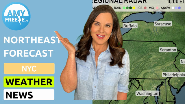
Greetings from Amy Freeze, your trusted meteorologist, bringing you the latest from the Midwest’s varied climate this April. From Chicago’s cool breezes and partial sunlight to unexpected snow showers across Indiana and Ohio, the region offers an interesting mix. Dive deeper into what these changes mean for your daily routine and how to best prepare for each day’s weather surprises. Stay informed, stay prepared!
The Midwest radar reveals an active weather pattern. A band of mixed precipitation is sweeping across states including Illinois, Indiana, and Ohio. Snow showers are making their way through areas like Fort Wayne, Detroit, and Cleveland. Residents in these regions are experiencing a winter touch as April progresses.
Farther south, rain dominates the scene. Indianapolis is seeing steady showers that continue to march eastward, enveloping Columbus and stretching into parts of Kentucky and West Virginia. Louisville and Bowling Green are also experiencing moderate rainfall.
More southward, Springfield and St. Louis are under a cloudy sky with sporadic rain showers, providing a damp start to the day in these locales. Chicago is on the northern edge of the rain bands, experiencing some cloud cover but staying relatively dry for now.
In the afternoon hours, Chicago’s temperatures are holding steady at 45 degrees with a gentle northeast wind around 7 miles per hour. We’ve got partly cloudy skies, which should let in some sunshine while keeping it cool. As we move toward 5 PM, expect similar conditions with an east wind at 7 miles per hour.
By 7 PM, temperatures will dip slightly to 43 degrees with an east-southeast wind at 6 miles per hour, continuing the pattern of partly cloudy skies. I
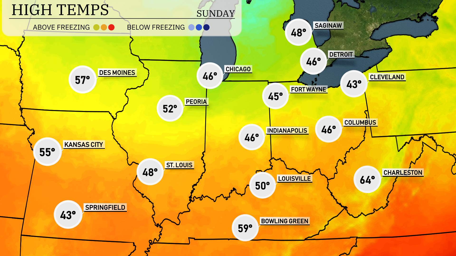
In Chicago, we’re looking at a cool high of 46 degrees, while Fort Wayne reaches just 45 degrees. Heading south to Indianapolis, expect a high of 46 degrees as well, keeping things consistently chilly.
St. Louis has a somewhat milder high of 48 degrees, but Kansas City is slightly warmer at 55 degrees. Over in Peoria, folks can enjoy a high of 52 degrees.
Meanwhile, Louisville stands out with a warmer high of 50 degrees, while nearby Bowling Green sees an even friendlier 59 degrees. And it’s a significantly warmer 64 degrees in Charleston, showing some nice variation across the region.
Tonight in the Midwest, expect a chilly night as colder air moves in. Here are the key low temperatures:
Minneapolis will dip to 21 degrees.
Chicago isn’t escaping the cold, with lows around 27 degrees.
Indianapolis will see 25 degrees.
In Peoria, temperatures will hover around 25 degrees as well.
The overnight low in St. Louis will be 28 degrees.
Kansas City can anticipate a low of 30 degrees.
A cold air pattern is firmly established, leading to notable temperature drops across the region.
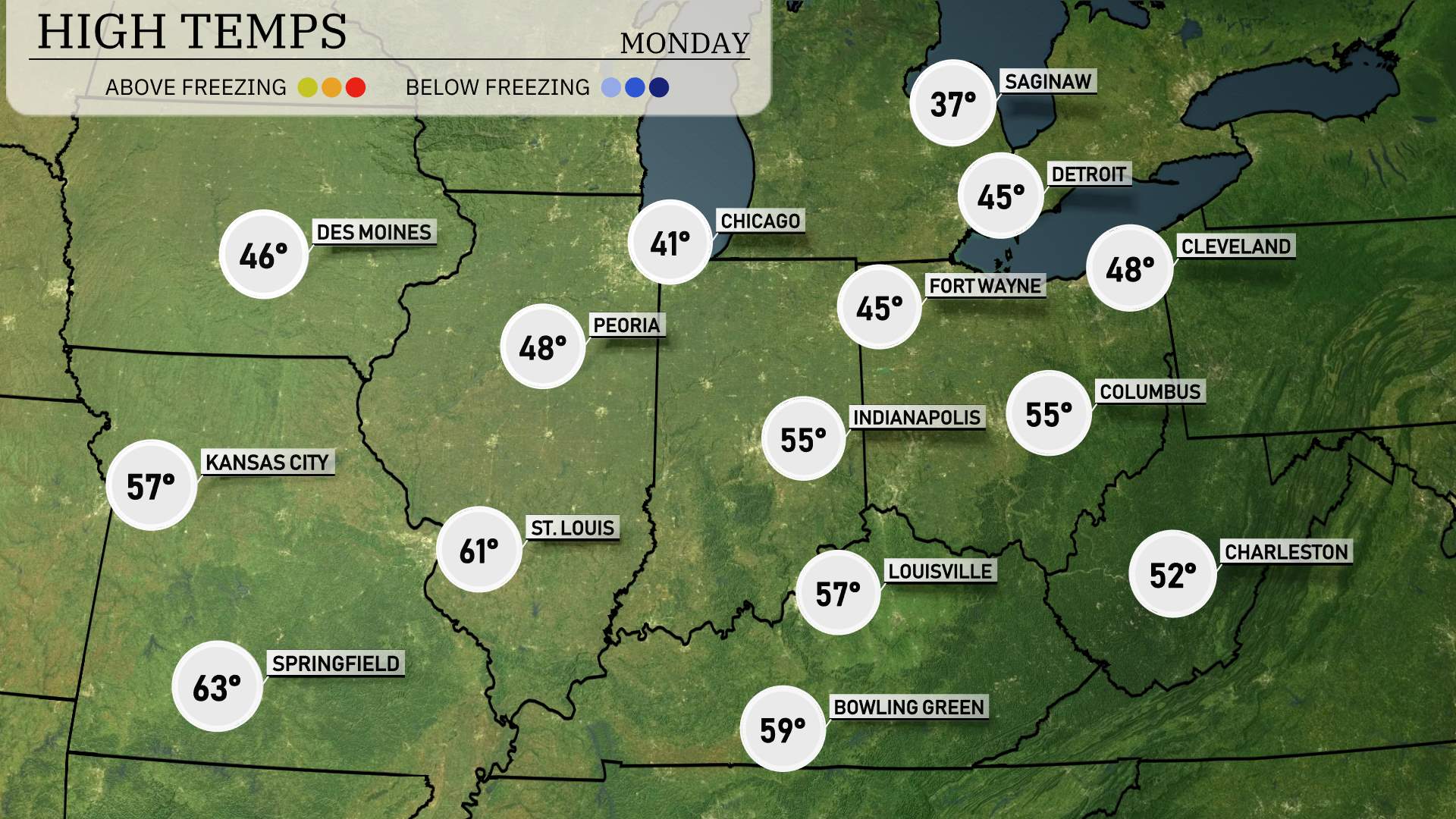
Tomorrow, the Midwest will experience a noticeable warm-up with many areas seeing temperatures above average for this time of year, primarily due to a ridge of high pressure settling in.
In Chicago, a high of 57 degrees is expected, while Peoria will reach 61. Over in Indianapolis, temperatures are predicted to hit 55 degrees. Kansas City will enjoy temperatures around 67 degrees, and St. Louis is forecasted to see a high of 61 degrees.
Further east, temperatures in Louisville will peak at 59 degrees, with Bowling Green not far behind at 56 degrees. Columbus is anticipated to warm up to 55 degrees, while Fort Wayne will be cooler at 48.
Prepare for a dynamic weather day across the Midwest. A low-pressure system will bring a mix of rain and snow, particularly impacting Indiana into Ohio. Expect heavy rain with potential for mixed precipitation from Indianapolis to Columbus. This could lead to slick conditions, especially during morning commute hours. Meanwhile, areas farther north like Chicago and Detroit will mainly see rain with a chance of isolated storms. Plan for gusty winds and monitor for severe weather alerts, as some areas fall under the SPC’s severe weather outlook. Temperatures will dip slightly following the frontal passage, but drier skies are anticipated by the end of Monday.
The UV index in Chicago will reach a moderate level of 6 on Sunday with a burn time of approximately 23 minutes. By Monday, the index slightly decreases to 5, extending the burn time to around 27 minutes.