Diverse Skies: A Comprehensive Midwest Weather Update by Amy Freeze
By
Amy Freeze
Discover how weather patterns across the Midwest are shaping up this week with Amy Freeze. From chilly temps in Chicago to mild warmth in St. Louis, get the full scoop!
From snowfall in saginaw to clear skies in Chicago, meteorologist Amy Freeze takes you through the Midwest’s current weather scenarios. Click to learn more!
April brings dynamic skies to the Midwest, as described by Amy Freeze. This informative post dives deep into various conditions from snow to sunshine. Expect comprehensive daily and weekly forecasts, highlighted by potential severe weather warnings and tips for staying prepared.
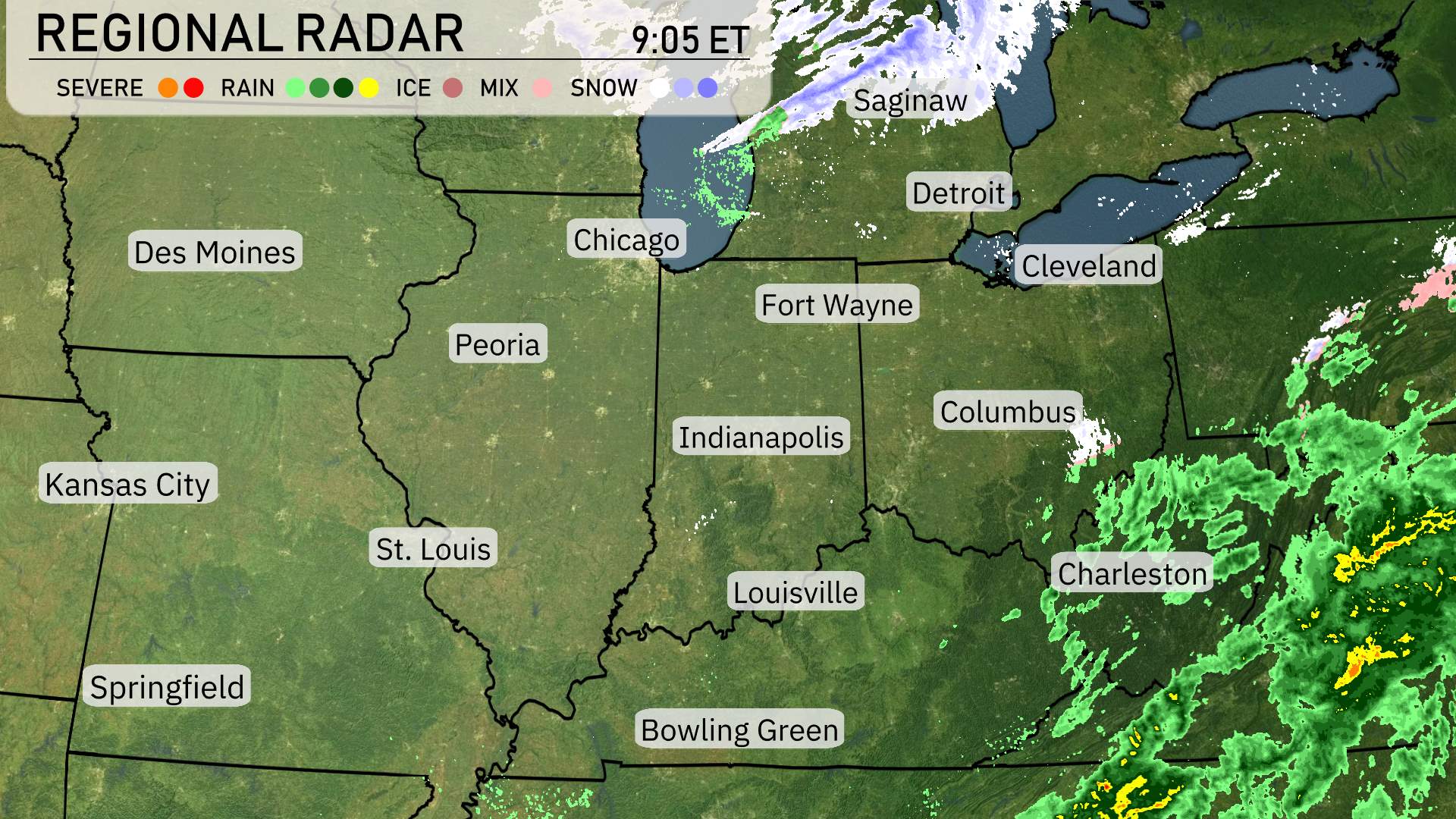
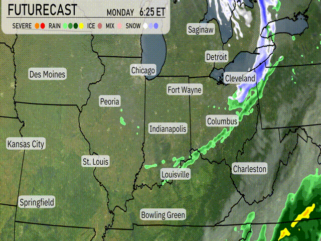
On the Regional Radar, the Midwest is seeing quite a range of weather conditions today. The northern parts, including Saginaw, are experiencing snow, which should be moving eastward. Meanwhile, further to the south and east, we have a significant swath of rain extending over the Ohio Valley and into regions like Columbus. This system is pushing towards Charleston and shows no signs of weakening.
Further west, cities such as Chicago and Des Moines enjoy clearer skies, offering a break from any precipitation. Kansas City and Springfield are under similar clear conditions, making it a pleasant day for outdoor activities.
To the east, Detroit and Cleveland are witnessing some patchy snow showers, adding a wintery feel to these areas. In Bowling Green and Indianapolis, the radar shows that any significant rain or snow is currently keeping its distance.
While Fort Wayne and surrounding regions prepare for potential increased cloud cover, places like St. Louis continue the trend of mild weather. As we move into the southern and eastern edges of this radar overview, the deeper south, including parts of the Carolinas, should gear up for the incoming rain.
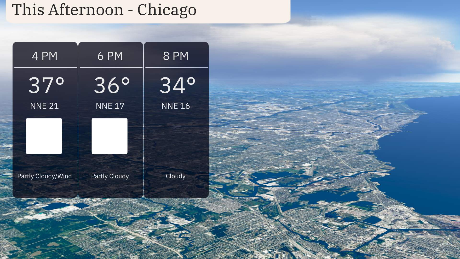
In Chicago this afternoon, temperatures remain cool, reaching 37 degrees by 4 PM. A north-northeast wind persists, blowing steadily around 21 miles per hour, gradually easing to 17 miles per hour by 6 PM. The sky will stay mostly partly cloudy throughout the afternoon, transitioning to more cloud cover as we move into the evening.
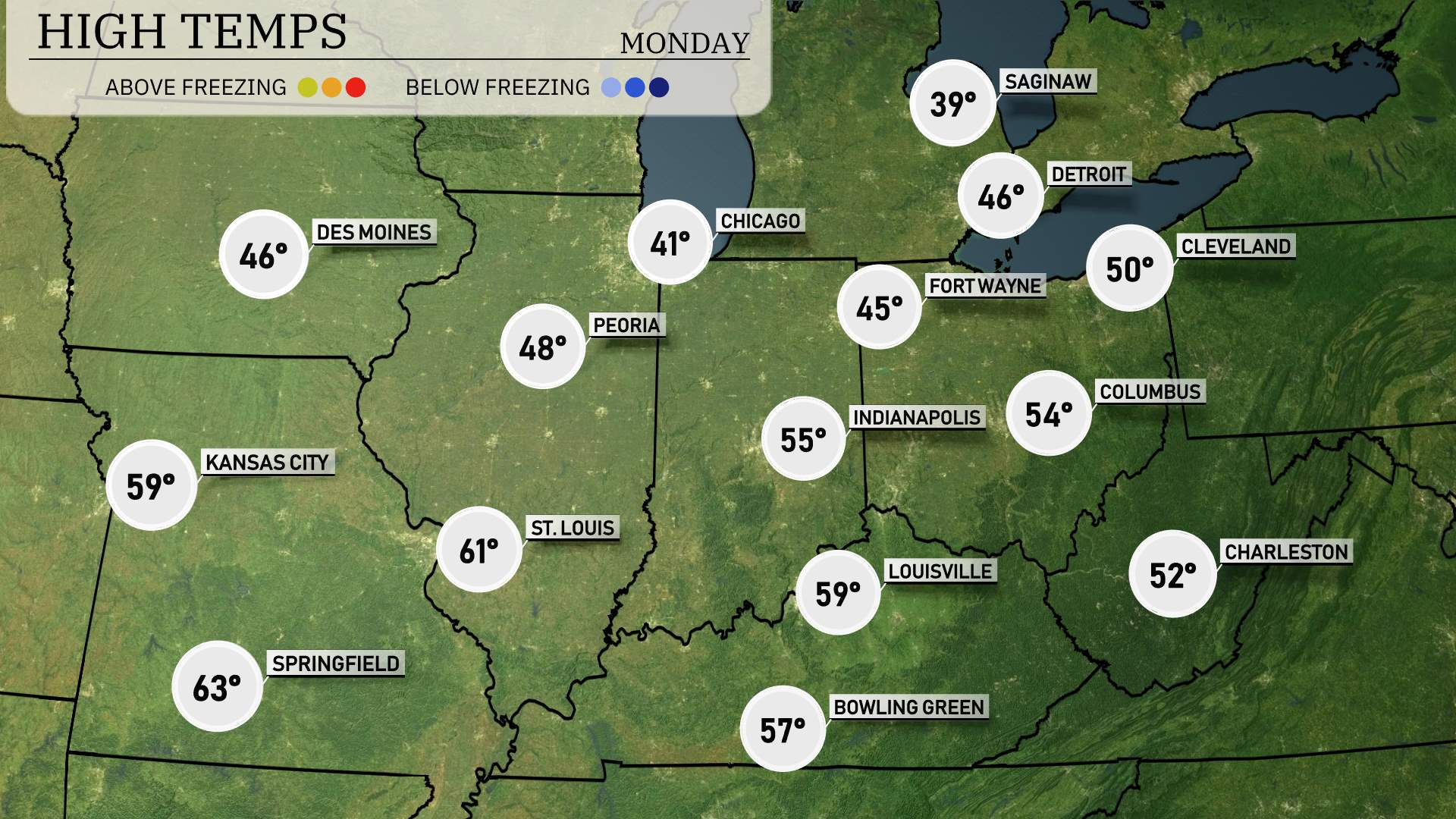
Let’s take a look at the high temperatures across the Midwest today. In Chicago, we’re settling at a chilly high of 41 degrees, while Peoria is slightly warmer at 48. St. Louis is enjoying more mild conditions with a high of 61 degrees, making it one of the warmest spots in the region. Heading into Indiana, Indianapolis sees a high of 55 degrees, while Fort Wayne is a bit cooler at 45.
Farther south, Louisville reaches 59 degrees, but the contrasting temperatures continue with Bowling Green at 57. Kansas City hits 59 as well, providing a nice balance across the area today.
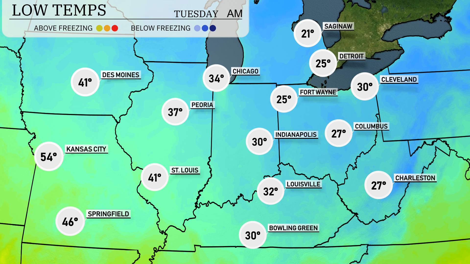
Now for the low temperatures, the Midwest is in for a cold night. Chicago will see a crisp low of 34 degrees, while Peoria drops to 37. Further south, St. Louis will hit 41 degrees, and Kansas City stays relatively warmer at 54. However, Indianapolis is bracing for a colder night at 30 degrees, with Columbus slightly chillier at 27. Fort Wayne and Cleveland will both experience lows of 25 and 30, respectively. The cold air mass continues to settle in, bringing significant drops across the region.
Tomorrow’s high temperatures in the Midwest will show a noticeable trend toward mild conditions, particularly across the southern portions of the region.
Kansas City is expected to reach a high of 64 degrees.
St. Louis will see a respectable 63 degrees, contributing to the overall warmer trend.
Peoria warms up to 50 degrees, more mild than recent days.
Cities to the north, like Chicago and Fort Wayne, will struggle with highs only around 39 degrees.
Indianapolis will see a slightly better high of 45 degrees but still below typical spring values.
Columbus gets 43 degrees, also below normal for early April.
An area of high pressure is influencing these conditions, creating a divide between milder temperatures to the south and cooler readings in the north.
A cold front moves into the Midwest by Monday evening, bringing a band of showers stretching from Chicago to Cleveland. Thunderstorms are possible, primarily around Indianapolis and Fort Wayne. Expect temperatures to drop by 10 to 15 degrees post-front, bringing cooler conditions on Tuesday. Rain will continue to track eastward into areas like Columbus and Charleston through Monday night, reducing as the front advances. Stay alert for any potential severe weather, as the Storm Prediction Center keeps an eye on the region for adverse conditions over the next 48 hours.
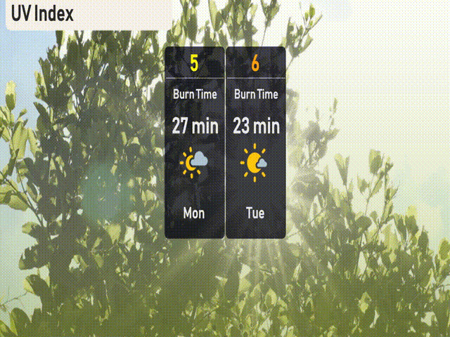
The UV index in Chicago will be moderate today (Monday) with a value of 5, leading to a burn time of approximately 27 minutes in direct sunlight. Tomorrow (Tuesday), the UV index is expected to rise to 6, with a quicker burn time of 23 minutes.