Amy Freeze provides an in-depth look at the swinging temperatures and storm forecasts rolling across Chicago and the wider Midwest region. Perfect reading to plan your week ahead!
Catch up with Meteorologist Amy Freeze as she breaks down the expected weather conditions across the Midwest, from cooler evenings to storm threats. Stay informed and prepared!
Welcome to your detailed Midwest weather guide by Meteorologist Amy Freeze. This week, Chicago and neighboring cities face various weather challenges, from cooler nights, scattered rainfalls, to potential severe storms early next week. We’ll also look at a change to colder and drier weather by the weekend. Comprehensive insights, safety tips, and more in this essential read as you plan your outdoor activities!
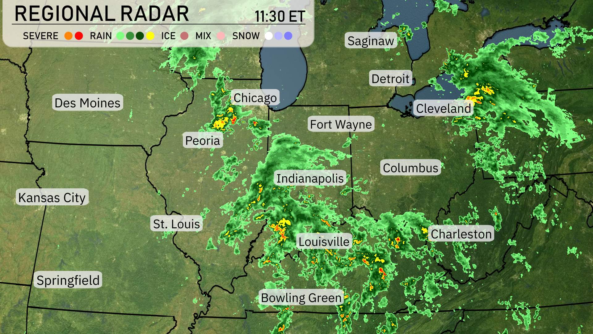
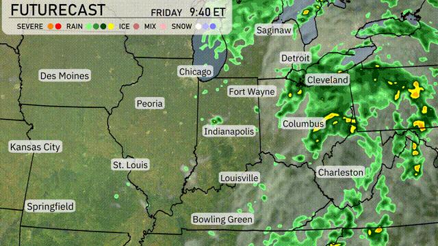
A substantial rain system is moving through the Midwest, extending from Chicago to Louisville. Heavier rainfall is currently affecting Indianapolis, with more scattered showers reaching Columbus. Fort Wayne and Detroit are experiencing moderate precipitation as the system advances. Areas like Cleveland and Charleston remain on the dry side, awaiting the impending weather front. Severe weather is expected Sunday into Monday for the Midwest.
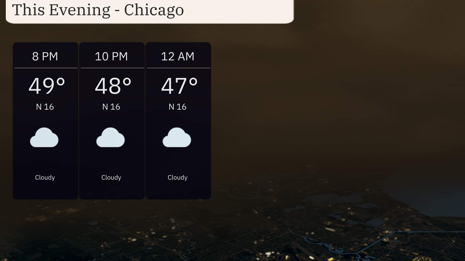
For this evening in Chicago, anticipate mostly cloudy skies with temperatures gradually decreasing from 49 degrees at 8 PM to 47 degrees by midnight. Expect a cool and brisk evening.
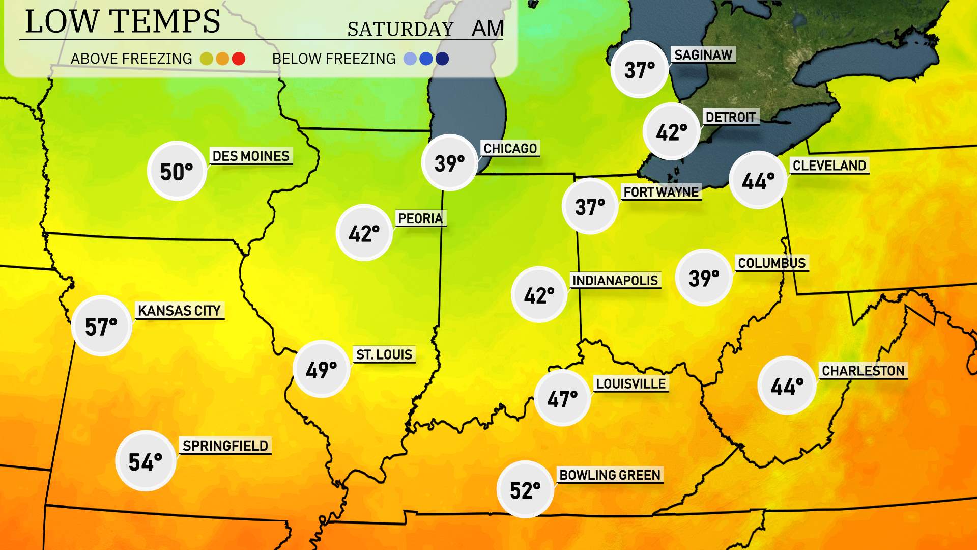
Tonight in the Midwest, temperatures will dip significantly as a cold front sweeps through the region. Chicago will see a low of 39 degrees, while Fort Wayne is forecasted to drop to 37. Indianapolis and Columbus will also experience lows of 42 and 39, respectively. Expect a chilly night across the area, with some locations like St. Louis staying slightly warmer at 49 degrees. Kansas City will cool off to 57 degrees.
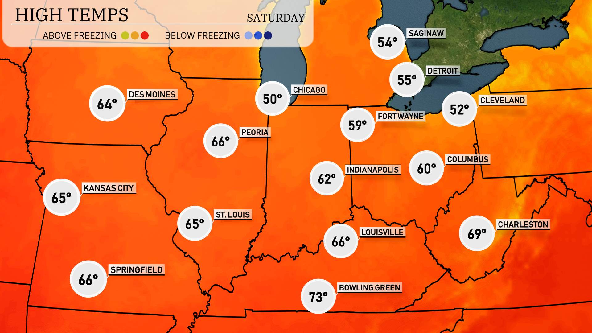
Tomorrow, the Midwest is expected to see pleasant highs, warmer than average in many areas. Chicago will manage a cool 50 degrees, while Peoria sizzles at 66. Indianapolis warms up to 62 degrees, and Louisville matches that with a high of 66. Kansas City should see a comfy 65 degrees, whereas Bowling Green takes the day with a warm 73.
A rainy day is ahead for the Midwest. Showers and storms are expected, especially in eastern regions like Cleveland and Columbus, where heavy rain might cause localized flooding. Temperatures will remain mild, but keep an eye out for enhanced gusty winds as the system moves through. Chicago and Indianapolis can expect scattered rain, diminishing by late evening. Prepare for a cooler and drier pattern settling in by the weekend.
Pay attention to outlooks from the Storm Prediction Center for a threatening weather system in place for early next week.
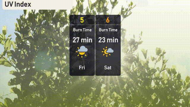
Chicago’s UV index will be moderate on Friday with a value of 5, leading to a burn time of 27 minutes in direct sunlight. On Saturday, the UV index increases to 6, with a faster burn time of 23 minutes.
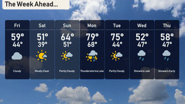
For the 7 day forecast in Chicago:
Friday: Cloudy throughout the day with a high reaching 59 degrees and a low of 44 degrees.
Saturday: Enjoy mostly clear skies with the temperature rising to 51 degrees and dipping to a chilly 39 at night.
Sunday: Partly cloudy conditions with a pleasant high of 64 degrees and a low of 51 degrees.
Monday: Thunderstorms are expected with temperatures soaring up to 79 degrees, cooling to 68 degrees overnight.
Tuesday: The skies clear up a bit, becoming partly cloudy with a high of 75 degrees and a low of 44 degrees.
Wednesday: Late showers are in the forecast, with temperatures reaching a high of 52 degrees and a low of 47 degrees.
Thursday: Early showers will start your day, leading to a high of 58 degrees with a low of 47 degrees.
Stay safe and enjoy the Windy City!