Clouds Over Chicago: A Comprehensive Midwest Weather Forecast
By
Amy Freeze
Explore the dynamic weather patterns affecting Chicago and the broader Midwest, from rain showers to temperature swings.
As we navigate another varied weather week in the Midwest, Chicago sees cloudy skies and sporadic showers. Stay tuned for daily updates!
Welcome to our detailed Midwest weather update. This week, Chicago will experience a mix of cloudy skies and occasional rain showers, with a steady temperature in the low 70s by afternoon. The region extends its wet conditions from Kansas City to Columbus, anticipating widespread showers. Looking ahead, the UV index suggests moderate to high exposure risks. Grab your umbrella, and let’s brace for a wet and unpredictable week!
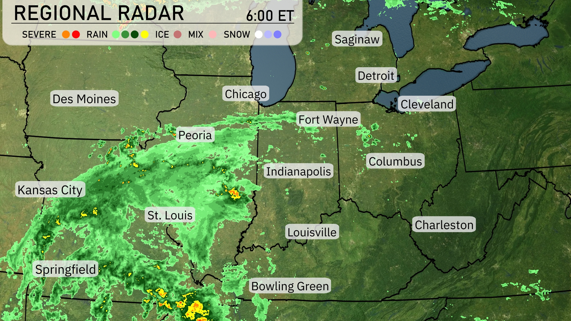
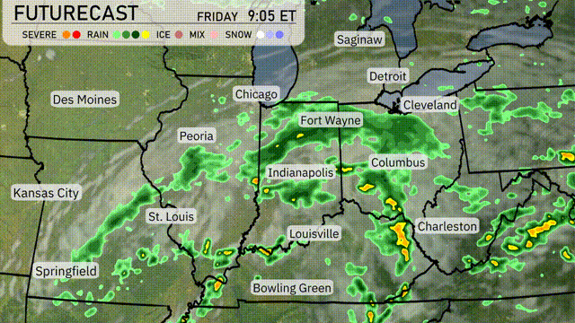
A significant weather system is bringing widespread rain across much of the Midwest, stretching from Springfield and St. Louis toward Fort Wayne and Indianapolis. The heaviest bands of rain hover near Kansas City, and showers are spreading northeastward toward Chicago. Louisville is experiencing steady showers, while isolated rain pockets dot Cleveland, Detroit, and as far east as Columbus. Cloud cover increases across Bowling Green and Charleston, setting the stage for potential rain development later in the day.
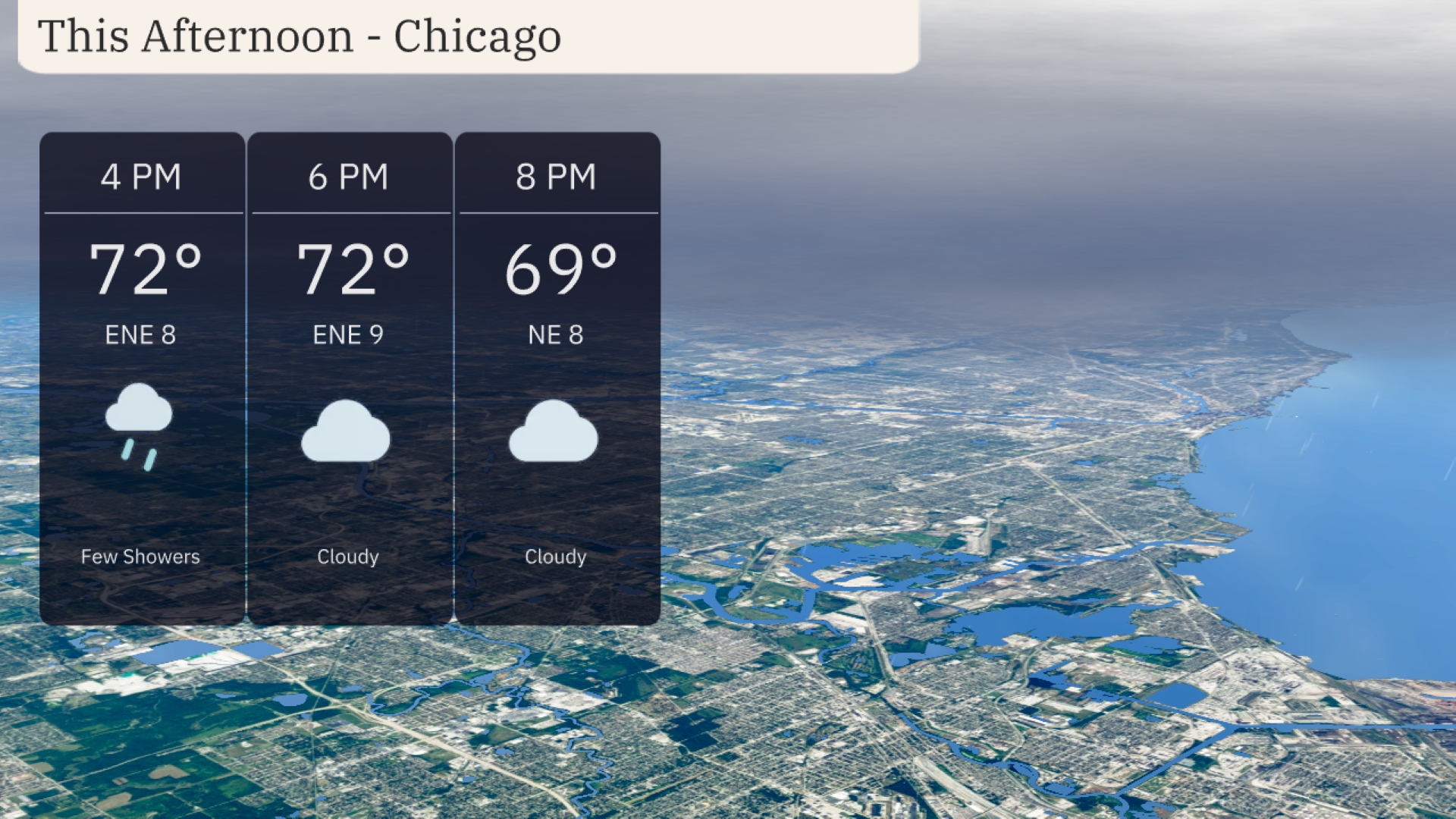
In Chicago this afternoon, expect temperatures to hold steady at 72 degrees by 4 PM with an east-northeast wind around 8 miles per hour, occasionally gusting higher. A few showers are possible later in the afternoon as cloudy conditions persist. As we move towards the evening, the temperature will gently drop to 69 degrees by 8 PM, with continued cloud cover.
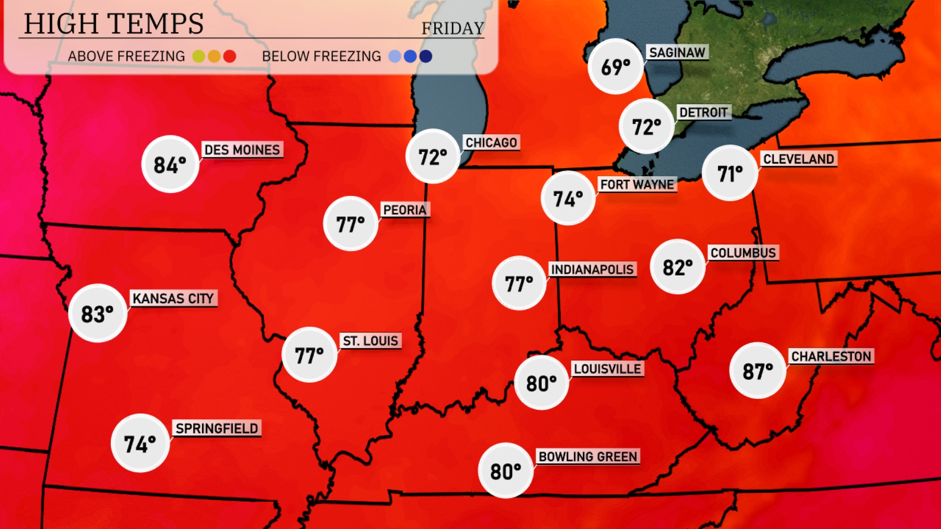
Today, we’re seeing warm temperatures across the Midwest. Indianapolis will heat up to 77. St. Louis is a bit warmer today at 77, and Kansas City tops out at 83. Louisville and Bowling Green each reach a summery 80 degrees. A cooler front keeps Fort Wayne at 74 and Detroit at just 72, creating a sharper contrast in the region.
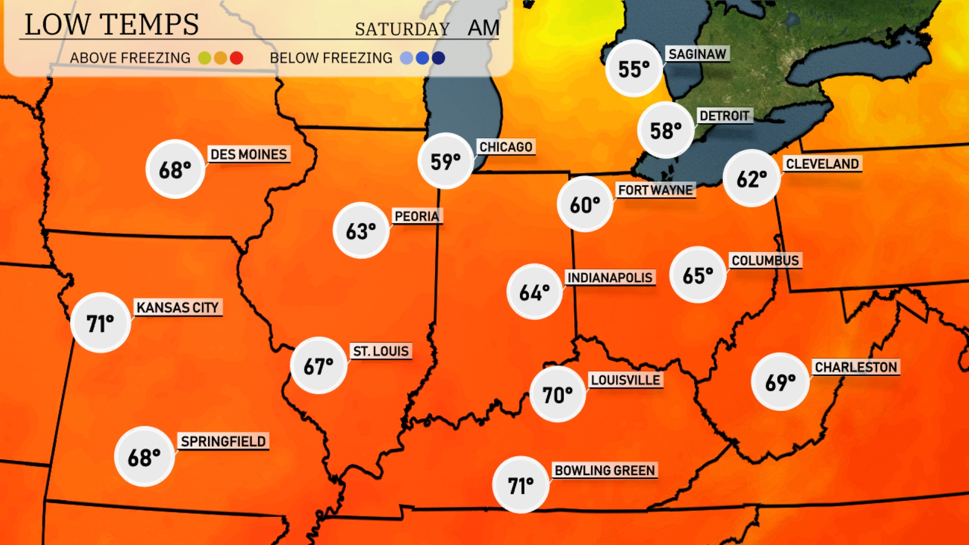
Tonight in the Midwest, expect lows around 55 degrees in Saginaw and 58 in Detroit. Chicago will cool down to 59 degrees, while Fort Wayne reaches 60 degrees. Farther south, Louisville is expected to dip to 70, with Kansas City slightly warmer at 71 degrees.
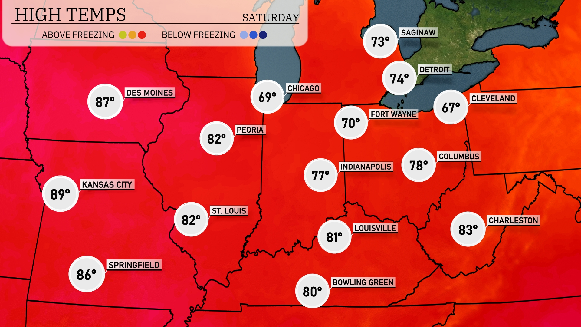
Tomorrow in the Midwest, highs will be well above average with Kansas City reaching 89 degrees. St. Louis will enjoy a warm day at 82 degrees, while Springfield follows closely at 86 degrees. Chicago will be cooler at 69 degrees, but still pleasant, and Fort Wayne is expected to hit 70 degrees.
Expect a wet day across the Midwest tomorrow as a low-pressure system drives moisture through the region. Areas from St. Louis to Indianapolis will see widespread showers with embedded thunderstorms, bringing locally heavy downpours. Stronger storms may briefly cause gusty winds and lightning, so keep an eye on the skies. As the system continues eastward, Louisville to Columbus should prepare for a soggy day, with potential flooding in low-lying areas.
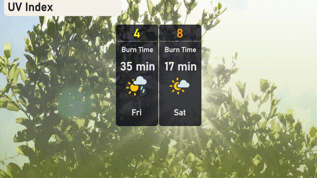
Chicago’s UV index on Friday is moderate at 4, suggesting a burn time of approximately 35 minutes in direct sunlight. As we head into Saturday, the index climbs to 8, bringing a higher risk with a burn time of just 17 minutes.