From Breezes to Storms: Your Comprehensive Midwest Weather Guide
By
Amy Freeze
Dive into a detailed analysis of this week's weather trends across the Midwest, from gentle breezes in Chicago to impending storms southeast of Detroit.
Expect a mixed bag of weather this week in the Midwest, with calm skies in Chicago and storms brewing towards Detroit. Stay tuned with Amy Freeze for daily updates.
Hello, weather enthusiasts! Meteorologist Amy Freeze here with an in-depth look at this week’s weather across the Midwest. From sunny highs in the afternoons to cool, starlit evenings, we have an exciting range of climates to discuss. Prepare for potential storms as we examine the weather moving from Detroit all the way to Chicago. Join me as we navigate through the daily and nightly shifts, ensuring you’re prepared for whatever the weather throws our way. Complete forecasts, safety tips, and more await you!
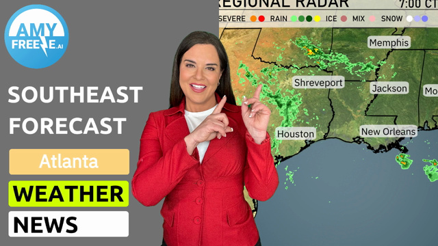
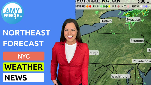
Today’s radar brings an exciting weather update for the Midwest! Over in Michigan, southeast of Detroit, a cluster of storms is making its way towards the city with lightning and heavy rains en route. Fort Wayne is also in the path of these storms, which continue their journey southeast. Meanwhile, the skies over areas like Chicago and Indianapolis are staying relatively calm with light scattered showers nearby. If you’re heading out in Columbus or Cleveland, expect some rain as the showers sweep through. Meanwhile, the Ohio Valley, stretching down towards Bowling Green and Charleston, is feeling the calm before the expected rain, with cloud cover gradually increasing.
For this evening in Chicago, anticipate clear skies with a gentle southwest breeze. Temperatures will gradually dip from 68 degrees at 8 PM to 65 degrees by midnight, creating a pleasant atmosphere for any late-night plans. The steady southwesterly wind will range from 17 to 19 miles per hour, adding a touch of coolness to the evening air.
Tonight in the Midwest, temperatures are dropping as a cold front pushes through. Chicago will see a low of 49 degrees, while Fort Wayne is expected to cool down to 58. Indianapolis checks in at 61 degrees. Moving south, St. Louis will register 63, and Kansas City will drop to 46 degrees. Notably,
High temperatures for the Midwest region tomorrow welcomes in some mild conditions. Here’s the breakdown:
Kansas City is expecting a high of 79 degrees, which is above average for this time of year.
Springfield follows closely with a high of 77 degrees, aligning with the trend of warmer weather.
Louisville is set to reach 75 degrees, while Bowling Green also sees a high of 75 degrees.
Over in Indianapolis, the temperature should hit 70 degrees.
Peoria will have a high of 69 degrees.
Cleveland reaches 73 degrees, while Detroit is expected to hit 71 degrees.
Overall, these temperatures are a nice departure from the cooler weather of the past week, driven by a ridge of high pressure building over the region, leading to a pleasant day ahead.
“Heading into Friday, the Midwest is on track for a relatively quiet weather day. A cold front pushed through earlier, leaving behind more mild conditions. Expect mostly clear skies from Des Moines to Indianapolis, with temperatures ranging from the upper 50s to mid-60s. Farther north, around Detroit and Cleveland, a few lingering rain showers might persist, but they will taper off by midday. Gusty winds are notable throughout the region, so keep an eye out if you’re headed outdoors. As we move into Saturday, expect dry conditions to continue, providing a nice start to the weekend.”
The UV index in Chicago today is moderate at 5, with a potential burn time of 27 minutes under direct sunlight. However, be aware of the rain today, which can reduce UV exposure. Tomorrow, the UV index drops to 2 due to expected cloud cover and rain, minimizing the risk of harmful sun exposure.
For the 7-day outlook in Chicago:
Friday: Mostly clear skies with a high of 76 degrees, dropping to a low of 60.
Saturday: Showers expected, with temperatures reaching a high of 66 degrees and a low of 53.
Sunday: Thunderstorms roll in, with a high of 65 degrees and a low of 37.
Monday: Partly cloudy and much cooler with a high of 40 degrees and a chilly low of 32.
Tuesday: Rain late in the day with the temperature peaking at 47 degrees and a low of 41.
Wednesday: Rain continues early, warming up a bit to a high of 63 degrees, and a low of 47.
Thursday: More showers with a high of 54 degrees and a low of 41.
Hope that helps! Stay safe and have a great week ahead!