Navigating Midwest Weather Patterns: A Comprehensive Guide by Amy Freeze
By
Amy Freeze
Explore the dynamic weather of the Midwest as Amy Freeze breaks down this week's forecast, from thunderstorms to temperature dips, ensuring you stay prepared!
This week, the Midwest forecasts a variety of weather conditions. With rains intensifying and temperatures ranging from 46 to 79 degrees Fahrenheit, it’s essential to stay updated. Amy Freeze provides all the details you need!
Welcome to your detailed Midwest weather guide by Amy Freeze. This week, we see a fascinating mix of weather phenomena. From heavy rain in Indianapolis to cool, clear skies in Des Moines, and a dip in temperatures across Chicago, every day brings something new. Stay tuned as we navigate the weather changes together and keep you well-informed and prepared for any condition!
The Midwest is buzzing with activity this morning as we check out the radar. A significant band of rain stretches from Springfield to St. Louis, pushing northeastward, bringing wet conditions to the area. Expect the rain to intensify as it moves toward Indianapolis and up through Fort Wayne, with Louisville seeing some of the heaviest showers at the moment.
In the northwest, Des Moines enjoys some clear skies, while Kansas City is on the edge of this weather system, experiencing only light rain. Looking farther north, Detroit and Cleveland are under cloud cover, with the rain beginning to creep in from the west.
Moving east toward the Ohio Valley, Columbus is in the mix of steady rain, which is also spreading toward the Appalachians and as far southeast as Charleston. Saginaw is seeing a break from the wet conditions, enjoying a clear patch for now.
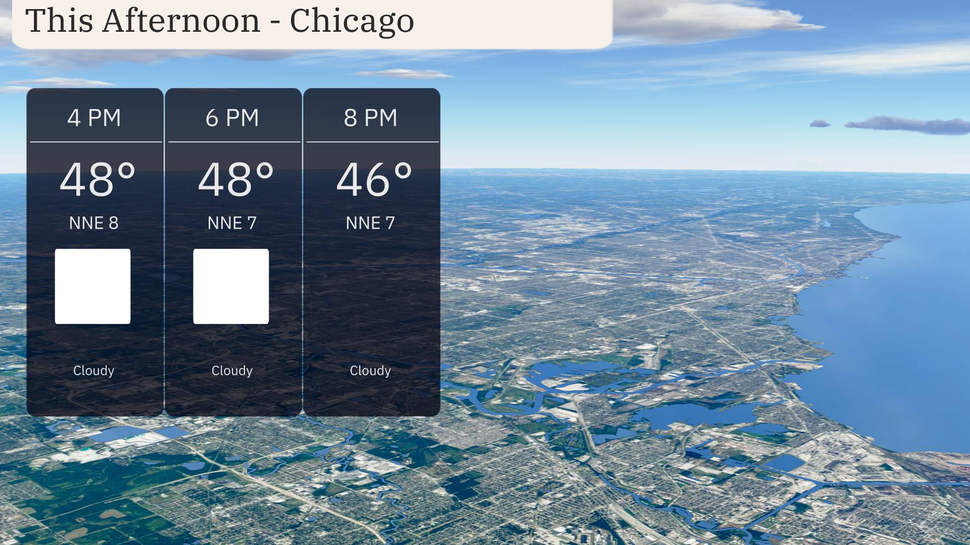
In Chicago, the afternoon forecast calls for cloudy skies with a gradual temperature decrease from 48 degrees at 4 PM to 46 degrees by 8 PM. Winds will be from the north-northeast at around 8 miles per hour, providing a gentle breeze.
Today, the Midwest is experiencing a range of temperatures. In Des Moines, it’s quite cool with a high of just 46 degrees. Kansas City follows closely, reaching 48 degrees, while St. Louis is slightly colder at 45.
As we move eastward, temperatures begin to rise; Peoria sees a high of 52 degrees and Fort Wayne hits 50. Indianapolis is notably warmer at 61 degrees, with Columbus reaching 68, indicating a warming trend as we head to the Ohio Valley.
In contrast, further south in Louisville, the high is a pleasant 66 degrees, and Bowling Green tops it off with a warm 70. Meanwhile, Charleston outshines everyone today with a warm high of 79 degrees.
Tonight in the Midwest, expect some stark temperature drops as cold air settles in. In the northern tier, Minneapolis will brush the freezing mark with a low of 30 degrees. Chicago will see 37, while Indianapolis will drop to 34. St. Louis can expect a chillier 32 degrees, and farther south in Louisville, it will be 37.
Springfield, Illinois will be the cold spot at just 28 degrees. Kansas City is forecasted to stay slightly warmer at 36 degrees. It’s a crisp night across the Midwest, and those venturing out should dress warmly!
Highs across the Midwest region tomorrow are expected to show a mix of above and below average temperatures as a cool front sweeps through.
In Chicago, temperatures will reach only 46 degrees, which is below the seasonal norm. Meanwhile, Peoria will see a brisk high of 54 degrees, while St. Louis expects a slightly warmer 50 degrees.
Indianapolis is forecasted to hit 46 degrees, aligning with the cooler trend. Bowling Green can anticipate a high of 52 degrees, and further south, Louisville will reach a high of 48 degrees.
Kansas City will see a high of 55 degrees, right around average for this time of year. Lastly, Des Moines, Iowa, is looking at a high of 57 degrees, providing some relief from the chill.
A frontal boundary is bringing showers and thunderstorms across the Midwest. Expect periods of heavy rain, especially around Indianapolis and Louisville, as storms progress eastward. This system could lead to brief wind gusts and isolated urban flooding due to rapid accumulations. Temperatures remain mild, but the passage of the storm front will cool things down late Saturday into the weekend. Watch the skies closely, especially in areas from Chicago to Fort Wayne as the line of storms travels farther eastward toward Cleveland by late Saturday.
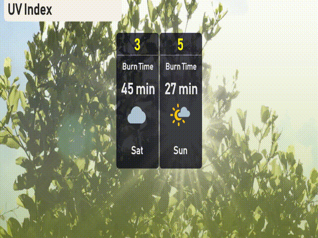
The UV index in Chicago will be low on Saturday due to the cloud cover, with a reading of 3. Enjoy outdoor activities without the risk of sunburn, but keep an eye on the weather if you’re planning to be outside all day. On Sunday, the UV index rises to a moderate level of 5, with a burn time of about 27 minutes under sunny skies.