Midwest Weather Watch: April Showers and Chilly Trends Unfold
By
Amy Freeze
Stay updated with meteorologist Amy Freeze as she brings you the latest weather insights across the Midwest, focusing on chilly trends and rainy forecasts. Dive into the details for a weather-ready week!
Delve into the latest Midwest weather trends with Amy Freeze! Expect cooler temperatures and rainy days ahead. Stay tuned and prepared with our detailed forecasts.
Explore an in-depth weather forecast for the Midwest as Amy Freeze highlights how unseasonal cool weather patterns and rain are impacting Chicago and beyond. With detailed temperature outlooks, city-specific forecasts, and weather warnings, this comprehensive guide ensures you’re fully prepped for the week.
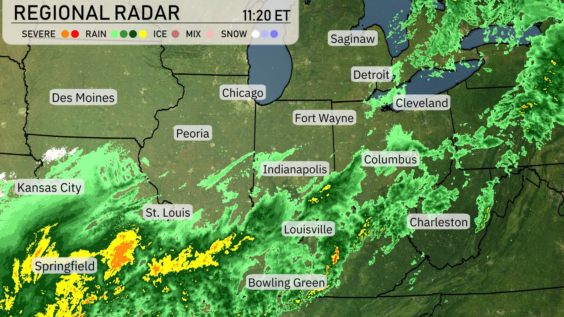
A dynamic weather pattern is sweeping through the Midwest today. On the radar, a band of rain stretches prominently, with heavier precipitation centered over St. Louis, pushing northeast toward Springfield. This system is heading toward Indianapolis, bringing steady rain, while showers continue to drench Columbus, further moving eastward.
Cloud cover is prevalent across Chicago and Detroit, with rain poised to follow. In the southeast, Charleston and Louisville are under persistent rain, making travel a bit tricky. Cleveland and Fort Wayne are also dealing with showers, indicating a wet day ahead. Conversely, areas like Des Moines and Kansas City are enjoying clearer skies, with no immediate threat of precipitation on the horizon.
This evening in Chicago, the weather will be cool with temperatures decreasing from 45 degrees at 9 PM to 41 degrees by 1 AM. Expect cloudy conditions early on, transitioning to mostly cloudy skies as the night progresses. Winds will shift from a northeasterly nine miles per hour to northerly, reaching up to eleven miles per hour later in the evening.
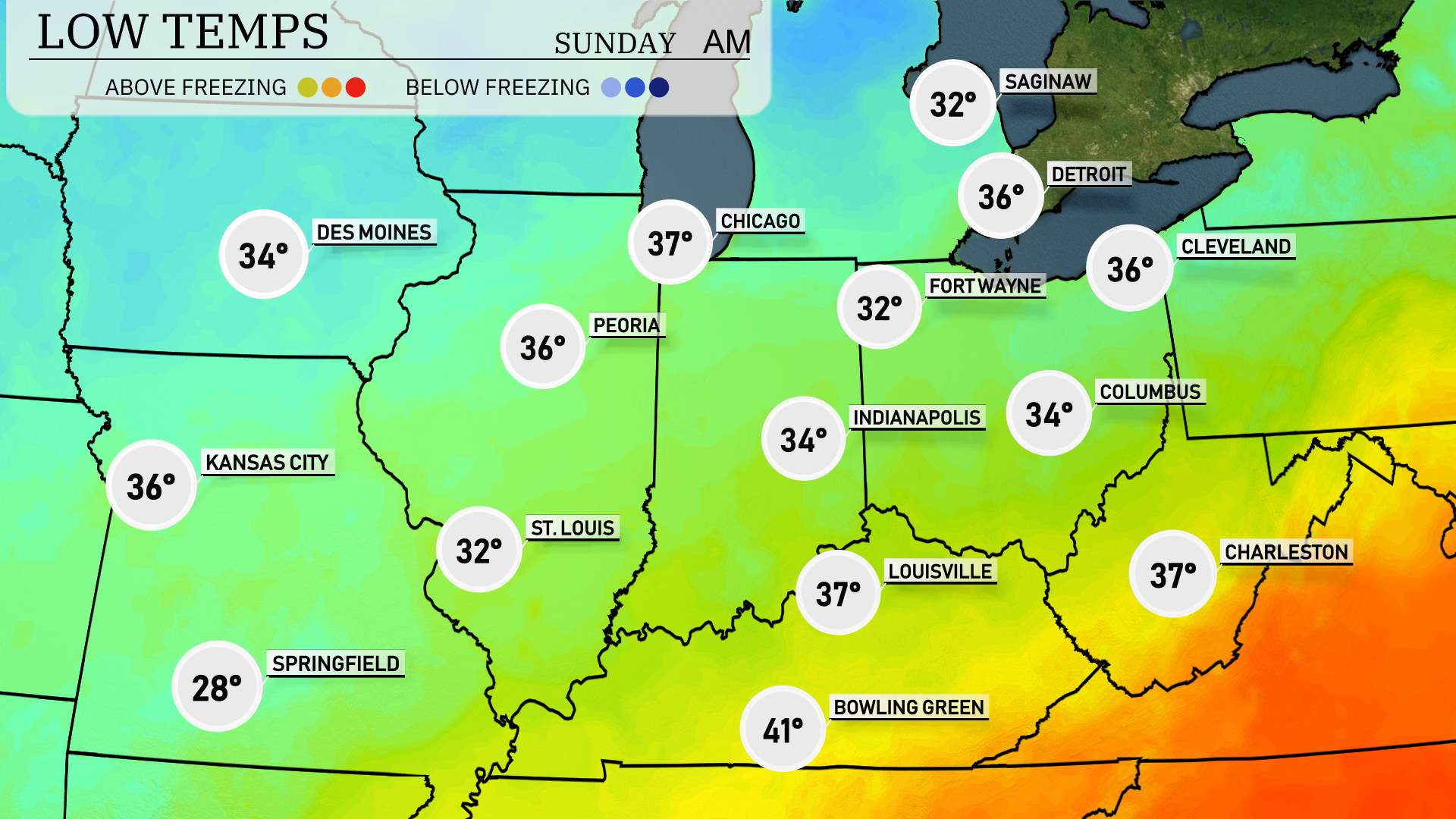
In the Midwest tonight, we’re looking at some chilly temperatures across the region. Chicago will dip to 37 degrees, with Indianapolis seeing a low of 34. St. Louis is expected to reach 32 degrees. Springfield stands out with a notably colder low of 28 degrees, while Kansas City is forecast to remain slightly warmer at 36 degrees. In the southern parts, Louisville will cool down to 37 degrees, and Bowling Green is expected to greet morning with 41 degrees. A notable cold air mass is settling in, so be prepared for a brisk night ahead.
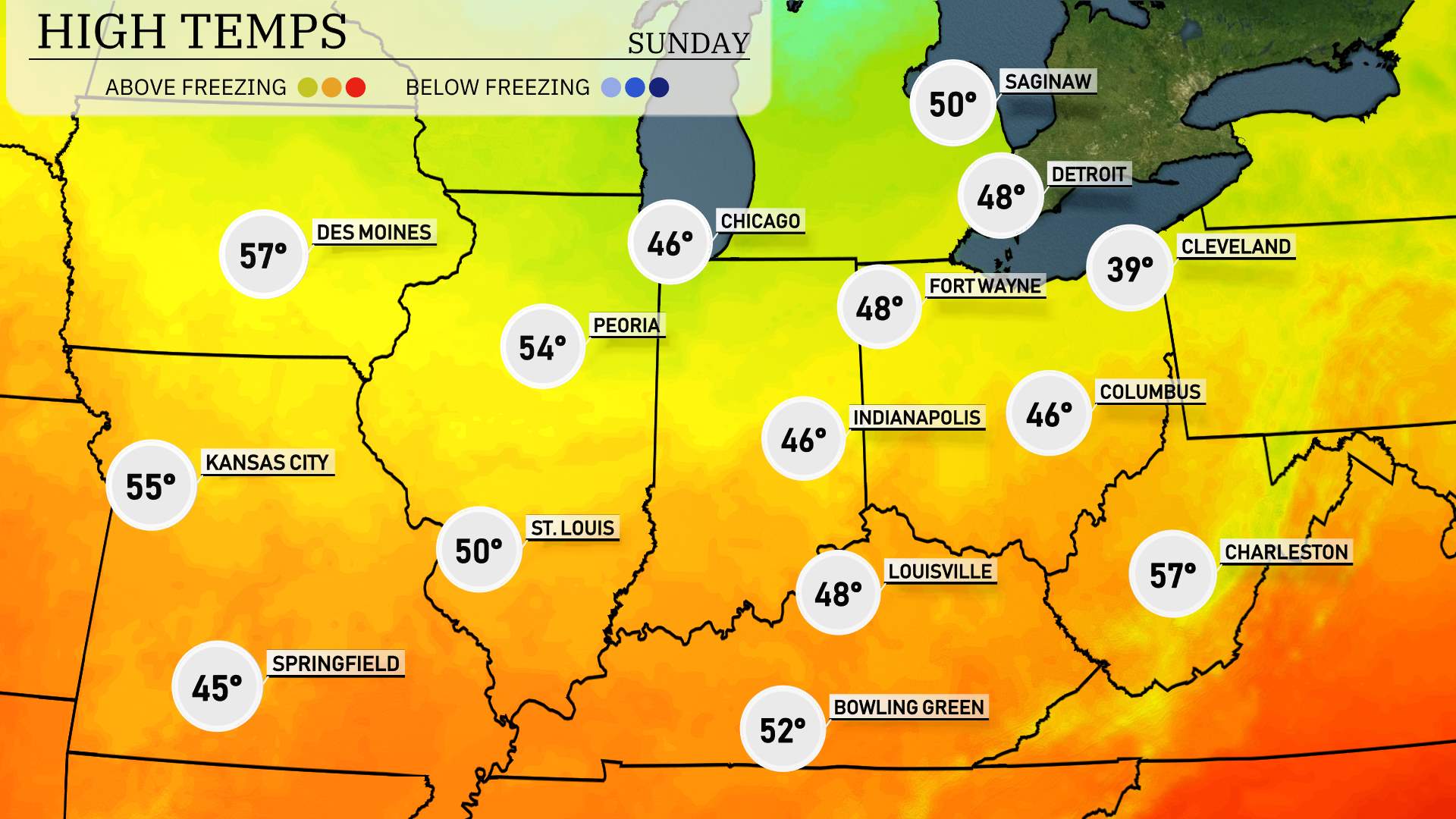
High temperatures across the Midwest tomorrow are looking notably varied, with many cities experiencing below-average readings for early April.
In Chicago, we’re expecting a high of just 46 degrees, which is well below the typical temperature for this time. Detroit will mirror this with a slightly warmer high of 48 degrees. Meanwhile, in Indianapolis, forecasters predict a similar high of 46 degrees, reflecting the cool conditions sweeping through the area.
Further south, St. Louis will manage to reach 50 degrees, while Peoria is anticipated to get up to 54 degrees. Louisville and Bowling Green are also on the cooler side, both expected to see highs of 48 and 52 degrees, respectively.
As we move eastward, Columbus will struggle to rise above 46 degrees, highlighting the chilly air mass in place. However, Charleston, West Virginia, will enjoy a slightly milder high of 57 degrees, offering a brief respite from the overall cool trend.
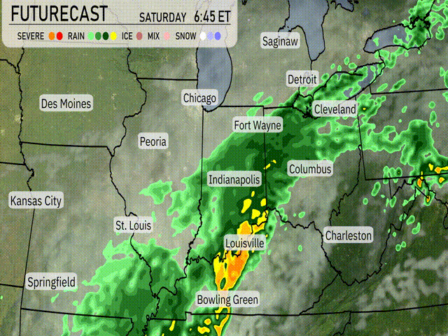
A cold front is advancing across the Midwest, bringing widespread rainfall and potential thunderstorms. Areas from St. Louis to Indianapolis and northward are expected to see steady showers transitioning to heavier rain by tomorrow afternoon. Louisville and Bowling Green should brace for periods of intense rainfall and strong winds, particularly late into the night. This system could cause brief flooding in low-lying areas. Colder air follows the front, leading temperatures to drop by approximately 10 degrees as we head into Sunday, with drier conditions returning. Remain alert for any severe weather alerts, especially for those in the Storm Prediction Center’s Severe Outlook zone, and plan for a potentially wet commute on Saturday.
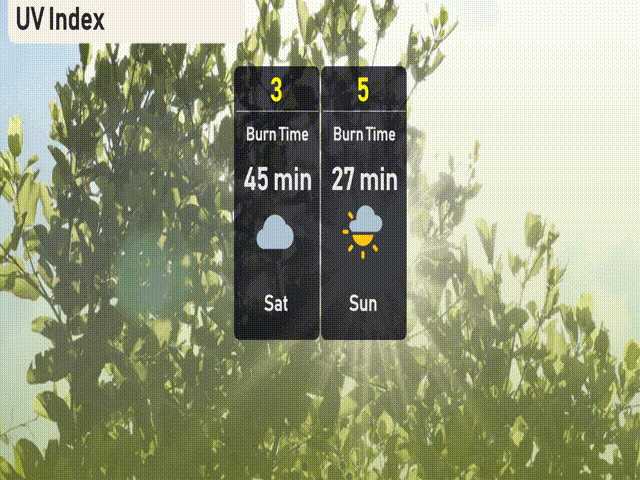
The UV index in Chicago is low today, with storms reducing exposure significantly. For Sunday, expect a moderate UV index of 5, leading to a burn time of about 27 minutes.
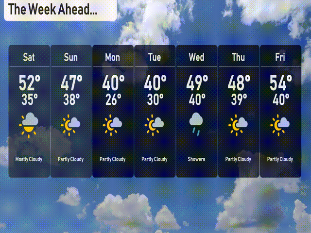
For the 7-day outlook in Chicago:
Saturday: Mostly cloudy with a high of 52 degrees, cooling to 35 overnight.
Sunday: A partly cloudy day, highs reaching 47 degrees, lows around 38.
Monday: Cold start to the week with partly cloudy skies, highs near 40 degrees and quite chilly with lows dropping to 26 at night.
Tuesday: Another cold day with sunshine peeking through, high of 40 degrees and a low of 30.
Wednesday: Rain moves in with showers expected, warming to 49 degrees during the day and a low of 40 at night.
Thursday: A cooler day with partly cloudy skies, high of 48 degrees, dipping to 39 overnight.
Friday: Partly cloudy conditions with temperatures reaching up to 54 degrees and a low around 40.
Hope that helps! Stay safe!