Midwest Mosaic: Weather Patterns Stir Chicago and Beyond
By
Amy Freeze
Explore how shifting weather patterns affect Chicago and neighboring areas, from serene skies to stormy nights. Stay ahead with our detailed forecast.
From clear skies to storm alerts, find out what the weather holds for Chicago and the Midwest this week. Detailed forecasts include temperature variations and storm warnings.
This week, Chicago and the surrounding Midwest region are experiencing a dynamic weather pattern. With a detailed look at the daily forecasts, shifts from clear skies to potentially hazardous thunderstorms are expected. Each day brings a new aspect of meteorological intrigue, from high UV indexes which pose health risks, to evening storms that could disrupt your plans. Our comprehensive guide will help you understand these patterns and plan accordingly, ensuring you are prepared for any weather eventuality. Explore our full insights in the blog post at https://amyfreeze.ai/
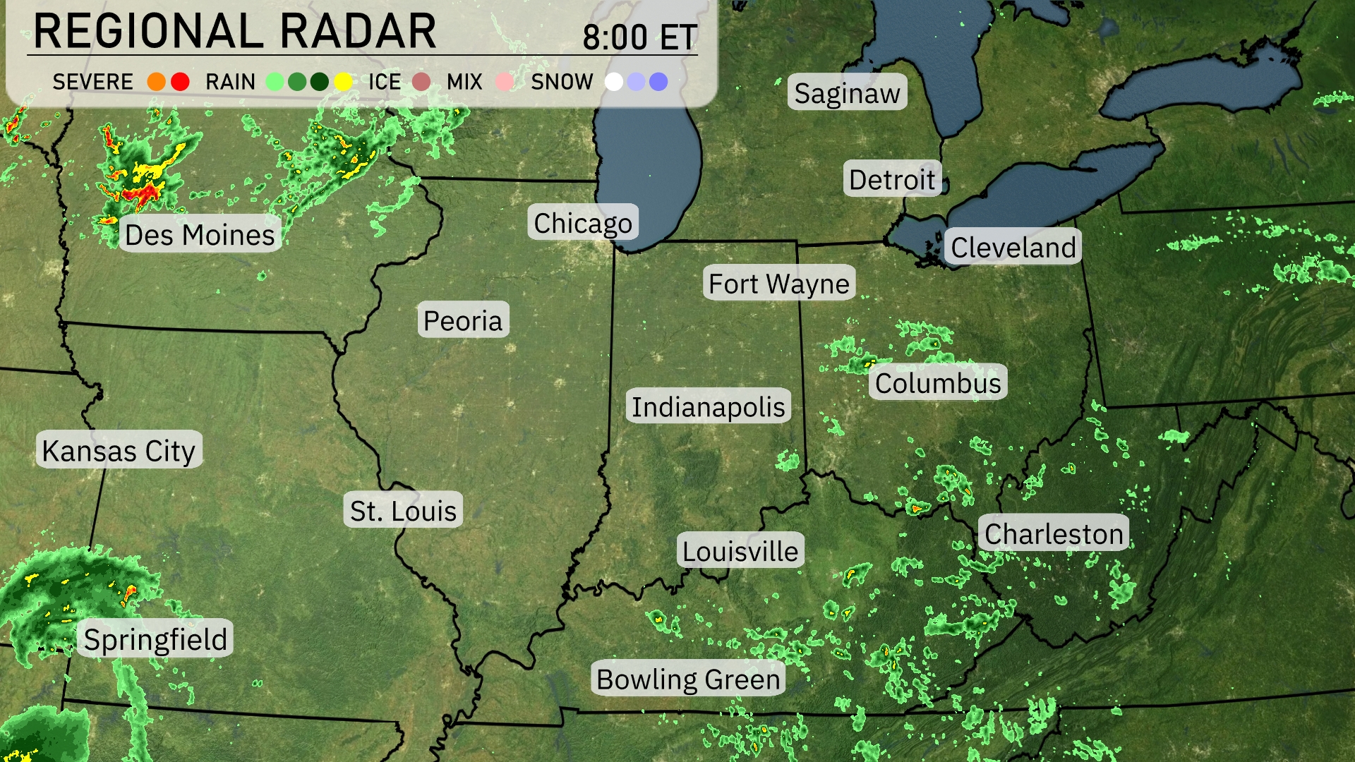
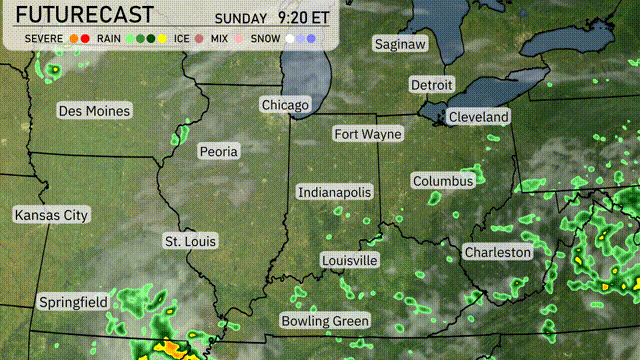
A cluster of severe thunderstorms is located to the northwest of Des Moines, moving towards the east, with significant rainfall. Further south, near Springfield, there is a developing storm system bringing rain showers into the region. The Ohio Valley from Indianapolis to Cleveland is mostly cloudy, interspersed with patches of light rain showers. The Great Lakes region, particularly around Detroit and Fort Wayne, remains relatively dry with scattered cloud cover.
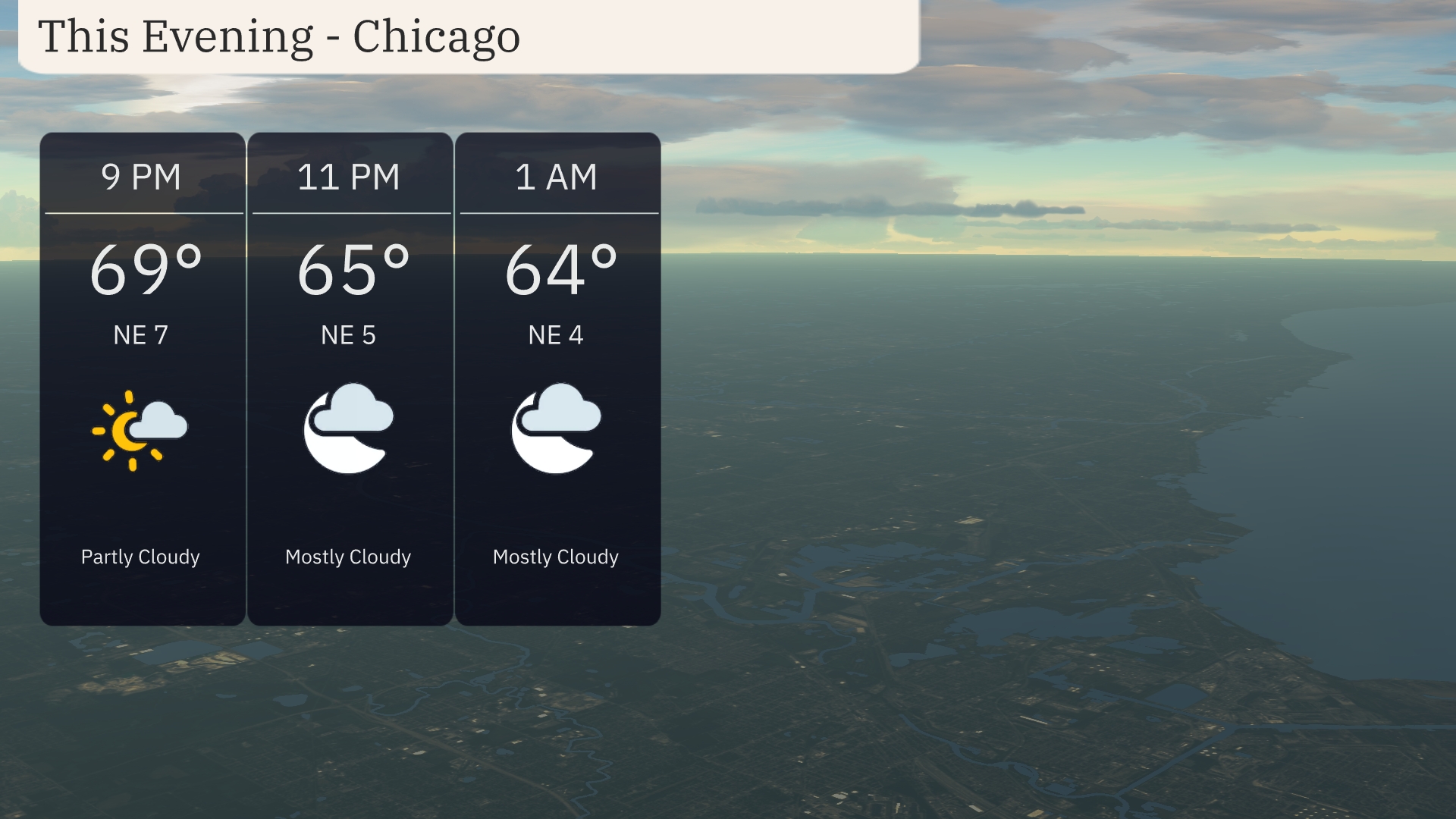
For this evening in Chicago, expect partly cloudy skies around 9 PM with temperatures at 69 degrees and a northeast breeze around 7 mph. By 11 PM, clouds increase, and temperatures dip to 65 degrees with winds easing to 5 mph. Clouds persist overnight into 1 AM, holding steady at 64 degrees with a gentle northeast wind of 4 mph.
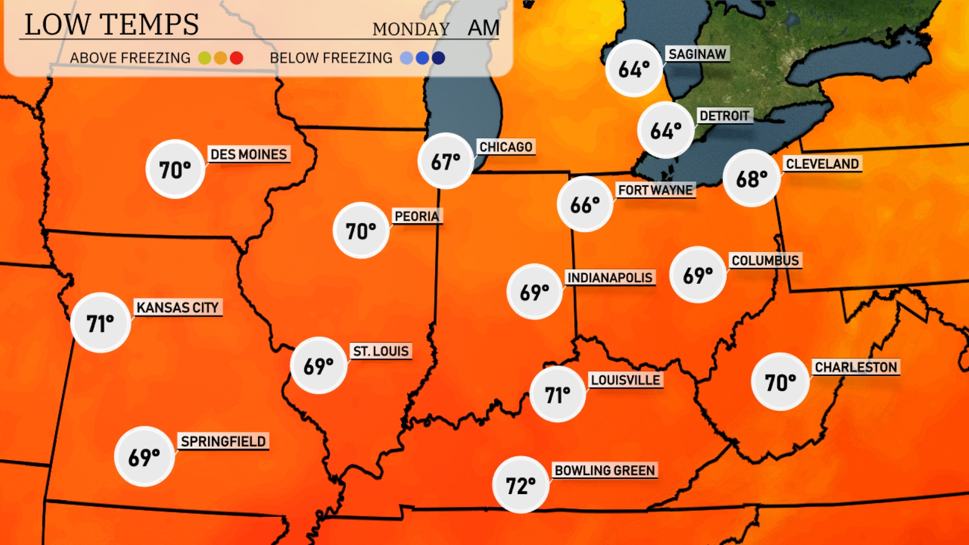
Tonight, Des Moines will cool down to 70 degrees, while Kansas City will also see a low of 71. Indianapolis is expected to drop to 69 degrees, and Peoria will match that with a low of 70. In contrast, St. Louis will stay slightly warmer at 69 degrees, with Louisville hitting 71.
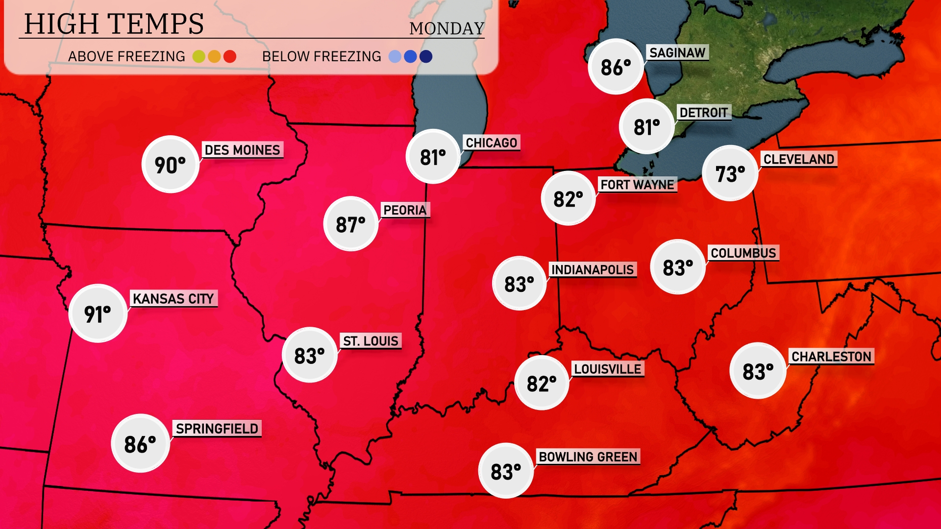
Tomorrow, high temperatures in the Midwest will be quite warm. Kansas City is expected to reach 91 degrees, while St. Louis and Peoria both warm up to 83 and 87 degrees, respectively. Chicago will hit a pleasant 81 degrees, and Indianapolis will see highs around 83 degrees. Notably, temperatures are running above average for this time of year due to a robust high-pressure system settling over the region, leading to clear skies and a lot of sunshine. Cleveland will be cooler at 73 degrees, under the influence of a weak frontal boundary.
A weather system brings scattered showers and thunderstorms across the Midwest, impacting areas including Chicago and Indianapolis tomorrow. Expect brief heavy downpours with these storms, especially during the afternoon, leading to localized flooding concerns. Temperatures remain warm, in the mid-80s, maintaining humid conditions despite periodic rain. St. Louis may experience stronger thunderstorm activity tonight, with gusty winds being a primary concern. As the system moves east, clearing skies are expected later in the day on Tuesday, bringing cooler and calmer weather into the evening.
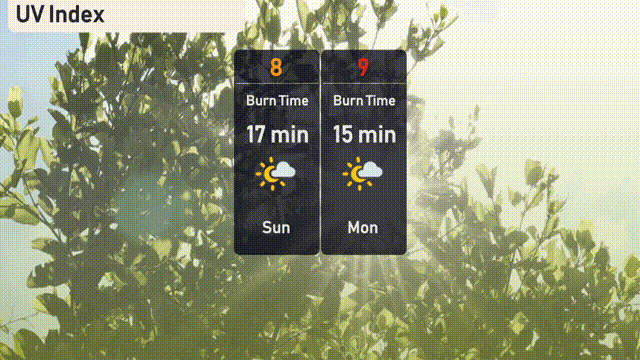
The UV index in Chicago will be high, reaching 8 on Sunday and very high at 9 on Monday, with burn times of 17 and 15 minutes respectively.
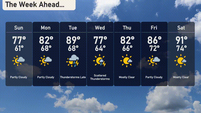
For the 7 Day Forecast in Chicago:
Sunday: Partly cloudy with a high of 77 degrees and a low of 61 degrees.
Monday: Warmer, high reaching up to 82 degrees, low at 68 degrees with mostly clear skies.
Tuesday: Thunderstorms are likely late in the day. Expect temperatures to peak at 89 degrees, with a low of 68 degrees.
Wednesday: Scattered thunderstorms expected, with highs around 77 degrees and a low of 64 degrees.
Thursday: Mostly clear skies anticipated with a high of 82 degrees and a low of 66 degrees.
Friday: Warmer and partly cloudy, high of 86 degrees and a low of 72 degrees.
Saturday: Mostly clear conditions return with a high of 91 degrees and a low of 74 degrees.