Catch up on the critical weather forecasts for Chicago and its surrounding areas as storms move through the Midwest. Stay prepared with our detailed evening update.
Tonight’s Midwest forecast brings a mix of partly cloudy skies and incoming storms. Check out our detailed report for Chicago’s evening weather and be ready for what’s ahead!
Welcome to your Midwest Evening Weather Forecast on this vibrant Chicago evening. As storms roll across the region, we offer a detailed look at what to expect in major cities including Chicago, Des Moines, and St. Louis. Discover how these conditions could impact your plans and how to stay safe during severe weather episodes. Join us as we delve into temperatures, storm timings, and more on https://amyfreeze.ai/
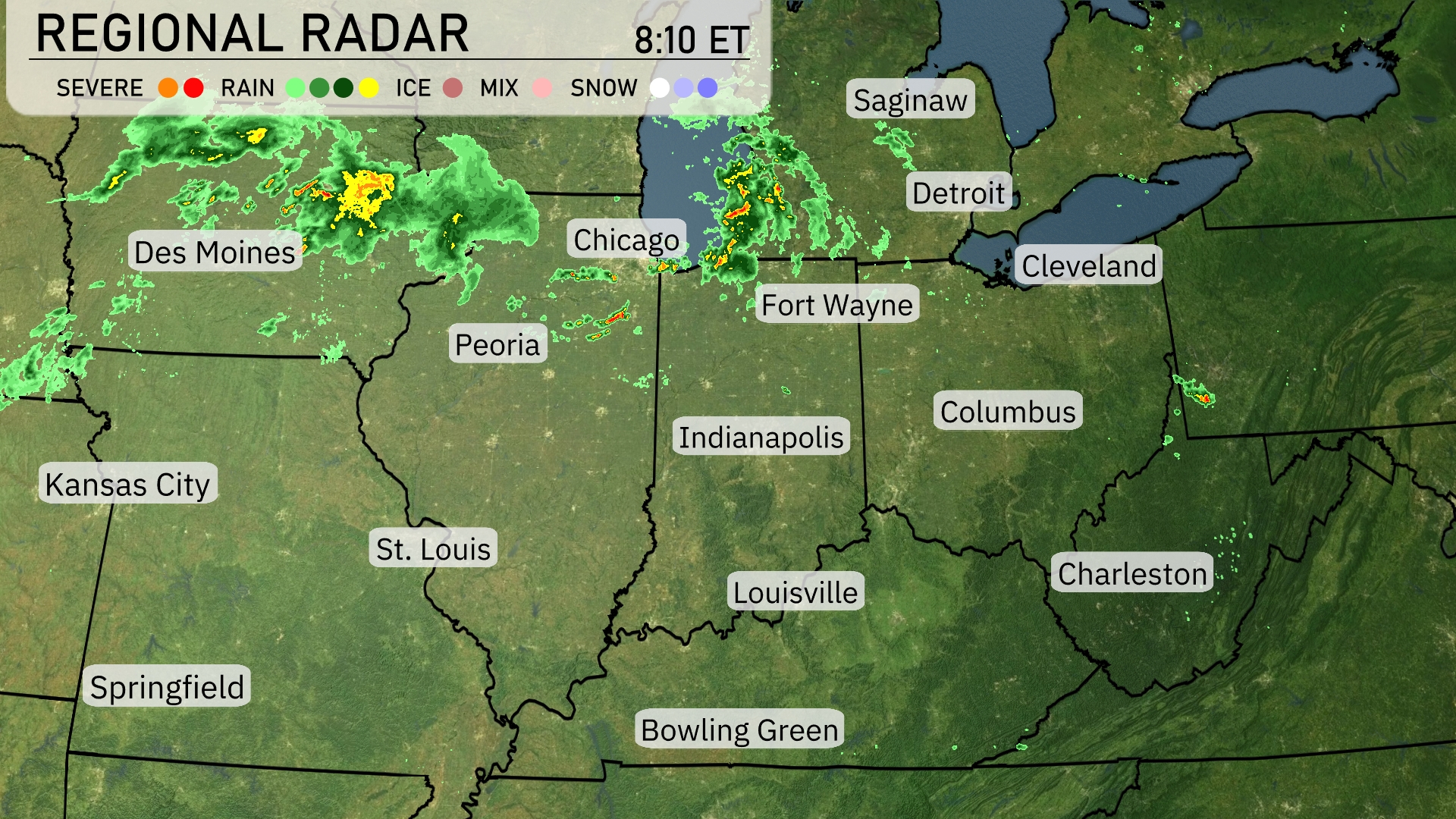
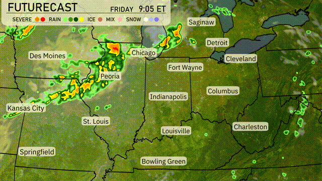
A line of storms is sweeping across the Midwest, with severe weather highlighted just north of Des Moines, pushing towards Chicago. Peoria is experiencing steady rain as these systems progress eastward. Fort Wayne is seeing scattered showers that are set to intensify as they merge with the incoming front. Detroit and Cleveland can expect increasing cloud cover and possible precipitation later in the day as the storm system moves southeastward.
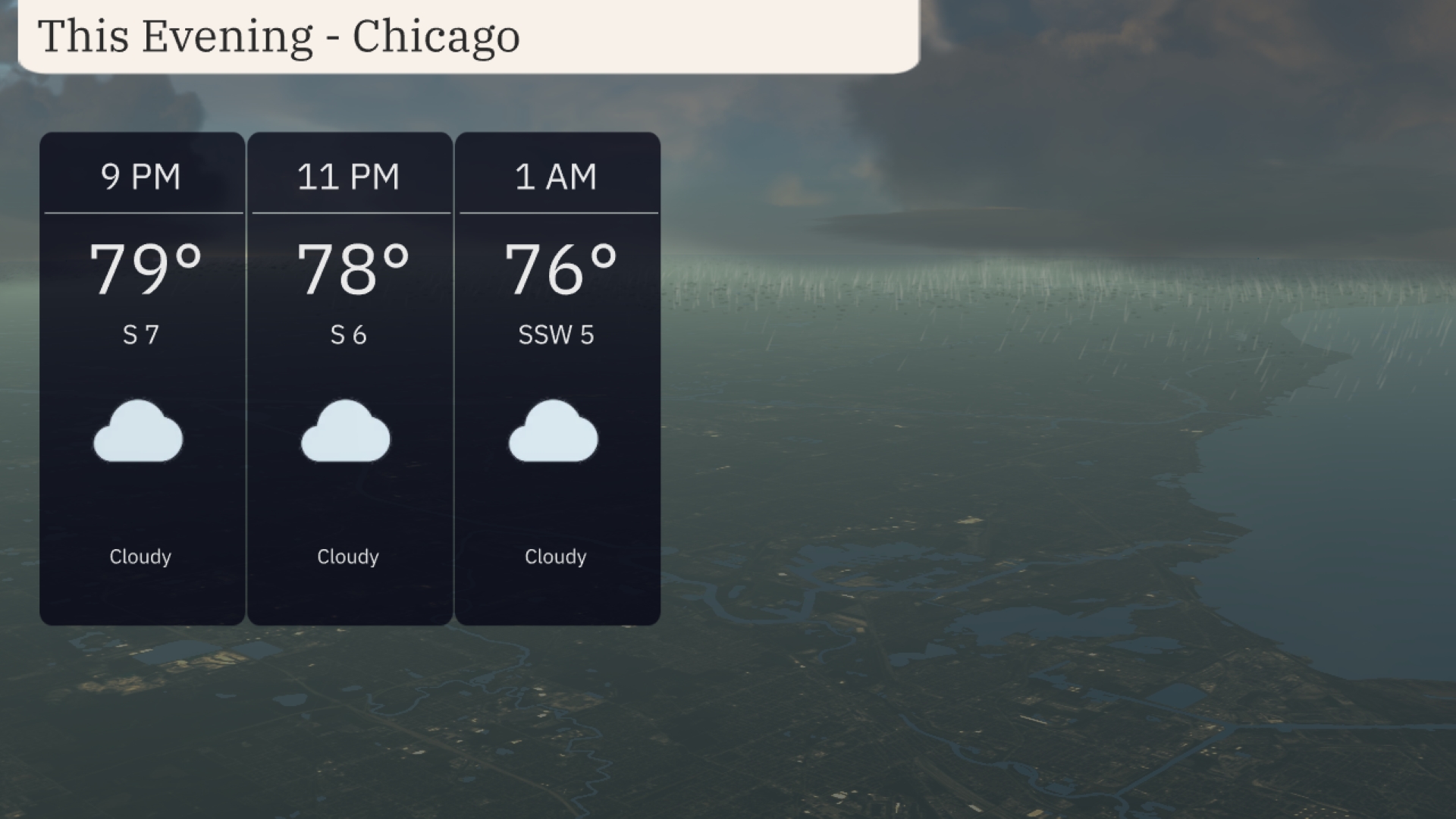
In Chicago this evening, temperatures will gradually decrease from 79 degrees at 9 PM to 76 degrees by 1 AM. Expect cloud cover throughout the evening, accompanied by gentle winds shifting from the south at 7 mph to the south-southwest at 5 mph. A mild night is ahead as cloudiness persists, with comfortable conditions for any evening plans.
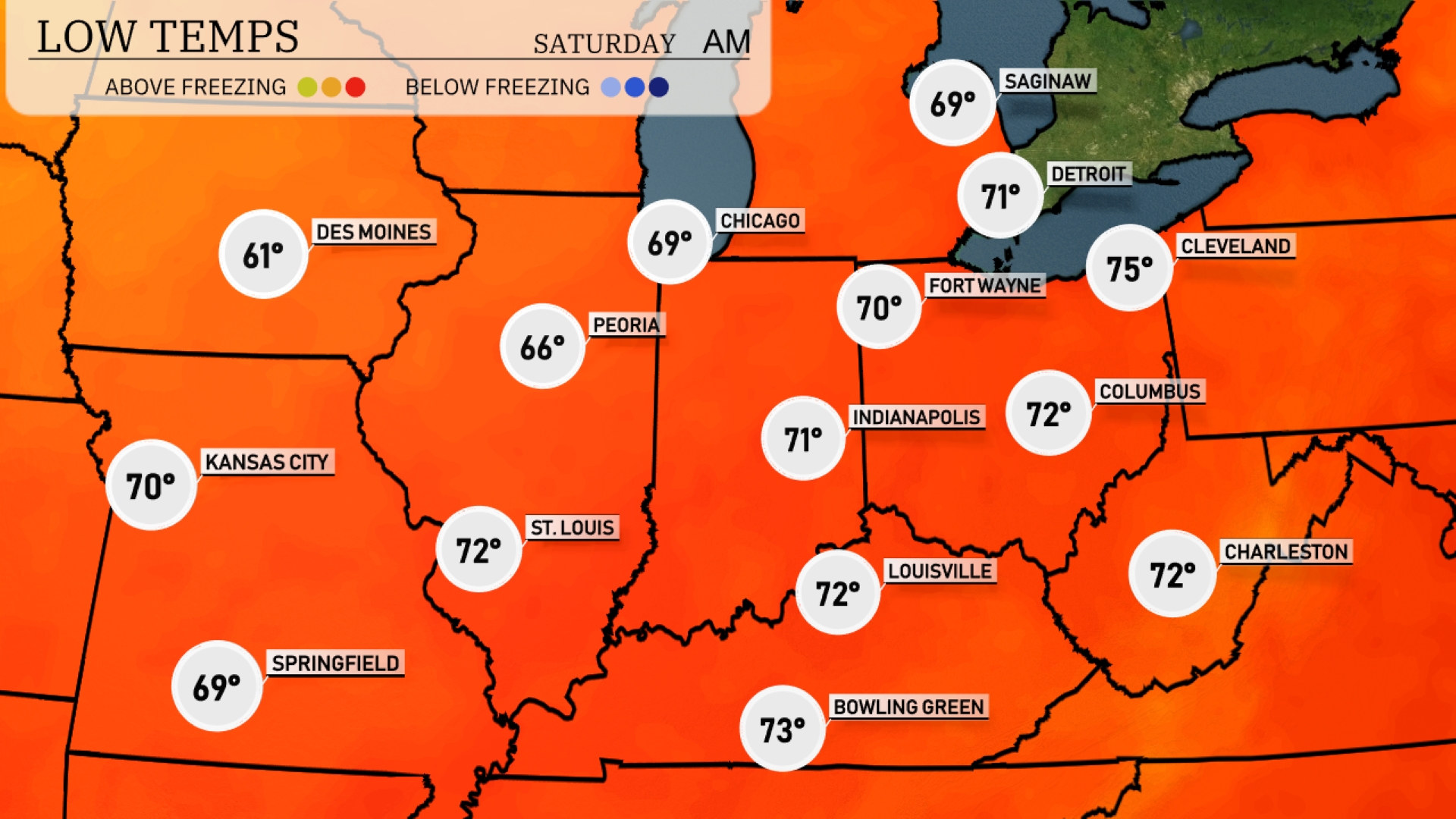
Tonight in the Midwest, temperatures will dip notably with Des Moines dropping to 61 degrees. Indianapolis is looking at a low of 71 degrees, while Chicago expects a milder night at 69 degrees. Kansas City will cool down to 70 degrees, and St. Louis will see a low of 72. Expect temperatures to remain above 60 in most major cities, but it’s a reminder that the cooler air is settling in.
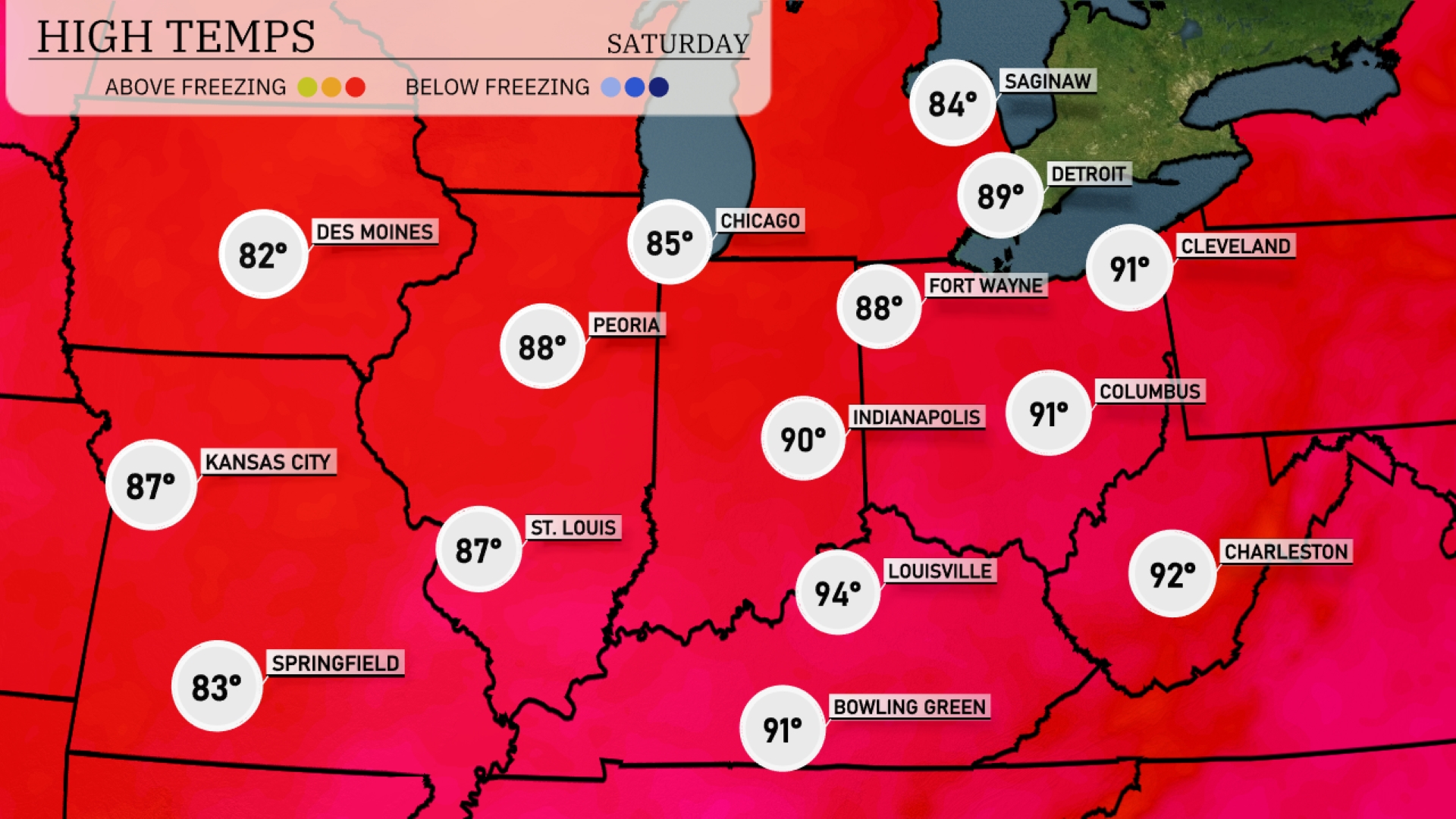
Tomorrow in Indianapolis, expect a high of 90 degrees, with temperatures in Fort Wayne reaching 88. Chicago will be warm at 85, while St. Louis is pegged for a high of 87. The hottest spot will be Louisville, hitting 94 degrees, significantly above average for this time of year. Kansas City is set to enjoy a warm day at 87 degrees, as the region experiences a surge of warm air influencing these highs.
A cold front is set to sweep through the Midwest, triggering storms and the potential for severe weather from Des Moines to Fort Wayne. Expect heavy rainfall and strong winds, particularly around Chicago and Peoria, which could lead to localized flooding on Saturday. As the system moves east, Detroit and Cleveland should brace for thunderstorms in the afternoon. Temperatures will drop slightly behind the front, bringing cooler conditions to St. Louis and Kansas City by Saturday evening.
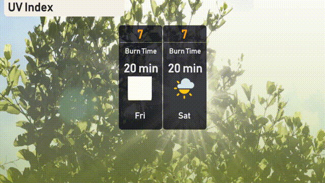
Chicago’s UV index is high at 7 on both Friday and Saturday, with a burn time of approximately 20 minutes under direct sunlight.
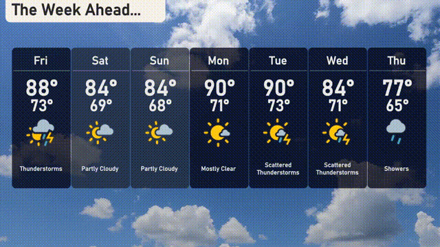
For the 7-day forecast in Chicago:
Friday: Thunderstorms with a high of 88 degrees and a low of 73 degrees.
Saturday: Partly cloudy skies with temperatures reaching a high of 84 degrees and a low of 69 degrees.
Sunday: Expect partly cloudy conditions again, with a high of 84 degrees and a low of 68 degrees.
Monday: Mostly clear skies, warming up to a high of 90 degrees and a low of 71 degrees.
Tuesday: Scattered thunderstorms are likely, with a high of 90 degrees and a low of 73 degrees.
Wednesday: More scattered thunderstorms expected, with a high of 84 degrees and a low of 71 degrees.
Thursday: Showers return, bringing cooler weather with a high of 77 degrees and a low of 65 degrees.