Chicago and Beyond: A Sweeping Glimpse at This Week’s Midwest Weather Trends
By
Amy Freeze
Explore how a mix of sunny days, thunderstorms, and a cold front are shaping up the Midwest's weather. From warm highs to stormy evenings, here's what to expect in Chicago and surrounding areas.
Catch up on the upcoming weather in the Midwest, from sizzling highs to stormy predictions. Click here for detailed forecast: https://amyfreeze.ai/
This week in the Midwest, we’re watching varying weather conditions sweep across the region. Chicago will start with comfortable evenings, but a line of storms from central Illinois is moving towards the area, bringing potential showers and an increase in cloud coverage. Find out how temperatures will climb before a cooling cold front hits, bringing rain and possible strong winds. Detailed daily projections for Chicago and neighboring cities are available on our blog at https://amyfreeze.ai/
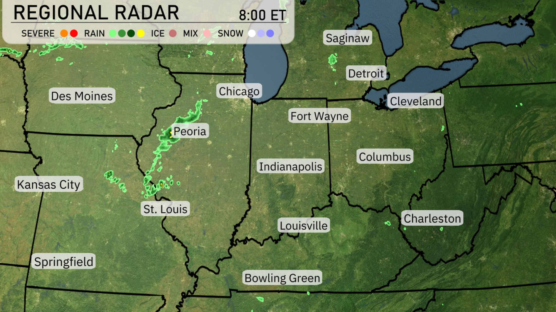
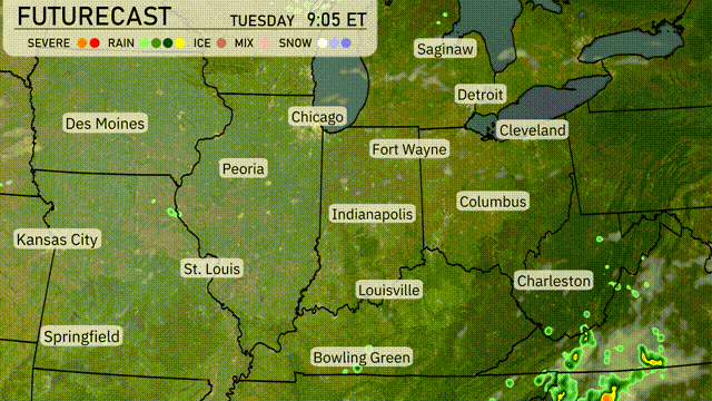
A line of storms extends from central Illinois southward towards St. Louis, creating a rainy start to the day for Peoria and nearby areas. Expect these showers to push northeast, bringing increased cloud coverage over Chicago. Indianapolis is experiencing rain showers moving in from the west. Most of the eastern part of the Midwest, including Detroit and Cleveland, remains dry with clear skies.
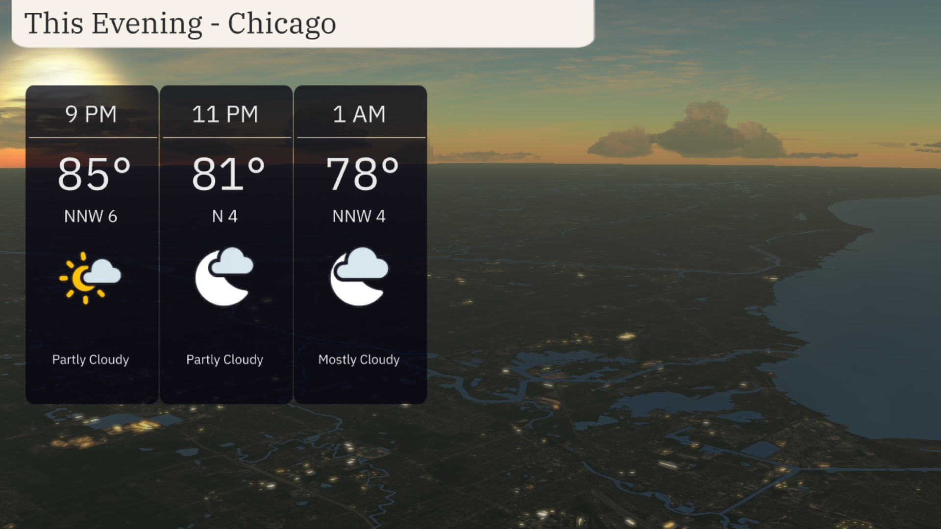
For this evening in Chicago, temperatures begin around 85 degrees at 9 PM, with a gentle northwest wind at 6 mph. By 11 PM, expect temperatures to drop to 81 degrees as the wind shifts to the north at 4 mph. Cloud cover increases, becoming mostly cloudy by 1 AM with temperatures at 78 degrees and a northwest breeze continuing at 4 mph.
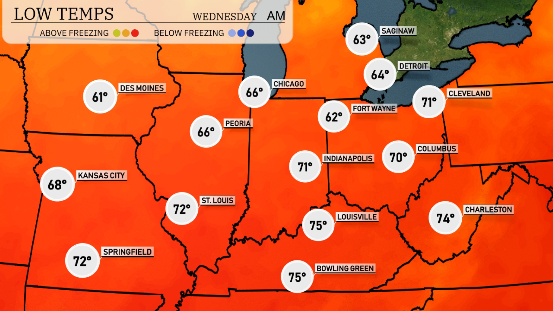
Tonight in the Midwest, expect lows around 61 degrees in Des Moines and 68 in Kansas City. Chicago will see a low of 66, while Peoria will drop to 66 as well. Indianapolis is projected to be a bit cooler at 71 degrees, with Columbus expected to hit 70.
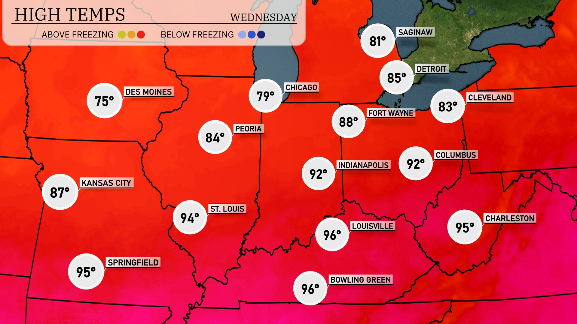
Tomorrow in the Midwest, temperatures soar with St. Louis reaching a sizzling 94 degrees, while Kansas City can expect a high of 87 degrees. In northern regions, Chicago will enjoy a pleasant 79 degrees and Fort Wayne will see a warm 88 degrees. Indianapolis is set to heat up to 92 degrees, and both Louisville and Bowling Green will hit a stifling 96 degrees.
A cold front is making its way into the Midwest, bringing scattered showers and thunderstorms from Kansas City through Indianapolis by tomorrow afternoon. Expect cooler temperatures with this front, dropping several degrees behind it as it moves east. Heavy bursts of rain with these storms could lead to localized flooding, particularly in low-lying areas. Strong winds are a possibility, so remain cautious, especially in open fields or near large trees.
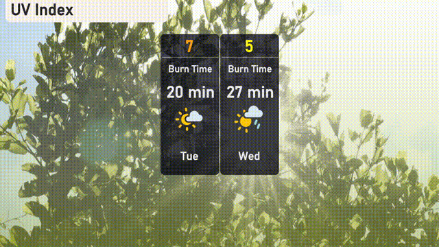
The UV index in Chicago for Tuesday is 7, indicating a high exposure risk with a burn time of about 20 minutes. On Wednesday, expect a UV index of 5 with a moderate exposure risk, resulting in a burn time of around 27 minutes.
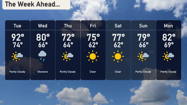
For the 7-day forecast in Chicago:
Tuesday: Partly cloudy skies with a high of 92 degrees and a low of 74 degrees.
Wednesday: Expect showers with the temperature peaking at 80 degrees and cooling down to 66 degrees.
Thursday: Partly cloudy, with a high of 72 degrees and a low of 64 degrees.
Friday: Clear skies, temperatures rising to 75 degrees and a low of 62 degrees.
Saturday: Another clear day, with the high reaching 77 degrees and the low at 62 degrees.
Sunday: Partly cloudy conditions, with a high of 79 degrees and a low of 66 degrees.
Monday: Partly cloudy skies continue, with temperatures climbing to 82 degrees and a low of 69 degrees.