Navigating Midwest Skies: A Comprehensive Storm and Weather Update
By
Amy Freeze
Meteorologist Amy Freeze provides an encompassing update on the moving weather patterns across the Midwest, including a sneak peek into tomorrow's forecast and storm alerts!
Get the latest on Chicago’s evening forecast and upcoming storm warnings across the Midwest in a detailed update from meteorologist Amy Freeze.
As evening sets in Chicago, the city braces for partly cloudy skies and a calm night, while a dynamic weather front moves across the Midwest. Amy Freeze breaks down the expected weather patterns, including storm alerts in Missouri and calm conditions in Chicago. Dive deep into each day’s specifics from cloud cover to expected rain showers, and prepare for a sudden drop in temperature tonight across the Midwest states. Don’t miss out on the detailed seven-day forecast!
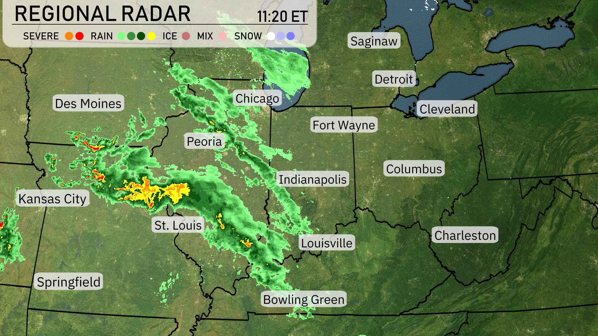
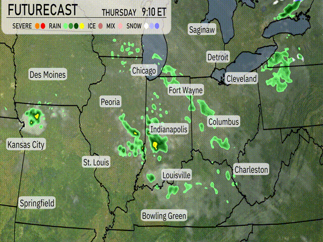
Across the Midwest, the regional radar shows an organized band of storms sweeping from western Missouri towards Illinois, with St. Louis currently experiencing heavy rain and potential severe storm conditions. Further north, areas like Springfield and Des Moines are under lighter rain, tapering off as we move towards Chicago, which is witnessing increasing cloud cover.
Peoria, caught in the path of this rain band, will see moderate showers progressing eastward. The line of precipitation stretches into Indiana, affecting areas like Indianapolis where rain is becoming more persistent as it moves eastward. Further east, cities such as Fort Wayne and Detroit have overcast skies but remain dry for now.
In Bowling Green and Louisville, expect showers to continue moving through, while Cleveland and Charleston are currently experiencing clear skies, though cloud cover will increase as the day progresses, potentially bringing showers later.
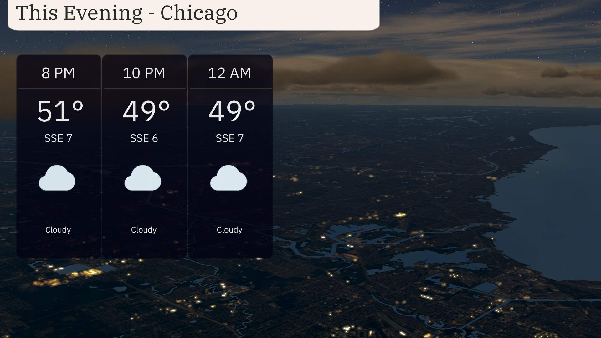
For this evening in Chicago, skies will remain cloudy with a steady breeze from the south-southeast. Temperatures will start at 51 degrees at 8 PM, cooling slightly to 49 degrees by 10 PM, and holding at 49 degrees through midnight. Expect consistent cloud cover and a light breeze, with winds around 7 miles per hour.
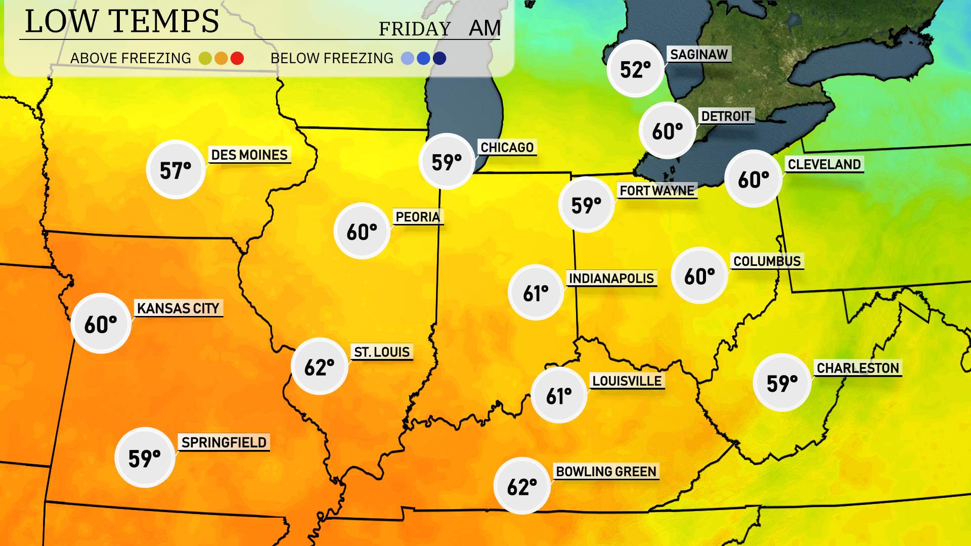
Tonight, the Midwest will experience a notable dip in temperatures. Chicago is looking at a low of 52 degrees, while Peoria will be slightly milder at 53. Indianapolis is expected to drop to 54 degrees, with St. Louis also seeing a low of 55.
In contrast, Kansas City will chill down to 56 degrees, while the northern tier will experience cooler conditions, with Fort Wayne forecasted at 49 degrees.
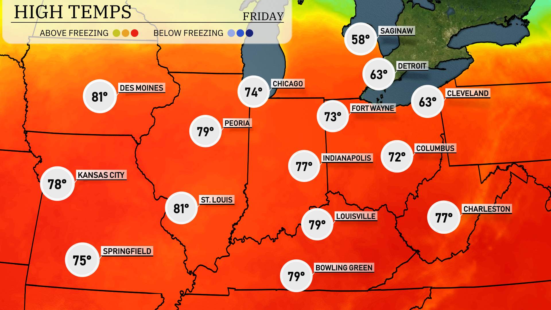
High temperatures for the Midwest region tomorrow are expected to be well above average, bringing a warm and pleasant day across many cities.
Kansas City is looking at a high of 78 degrees, while Springfield will enjoy a comfortable 75. St. Louis is set for a high of 81 degrees, making it one of the warmer spots in the region. Peoria will follow closely at 79 degrees, with Indianapolis expecting a high of 77.
Moving into Ohio, Columbus will see temperatures peaking at 72 degrees. Further east in Louisville, Kentucky, expect highs around 79 degrees, with similar readings in Bowling Green.
“A cold front is set to move through the Midwest tomorrow, beginning late tonight and progressing into Thursday. Expect scattered thunderstorms primarily in central Indiana, impacting areas like Indianapolis and Fort Wayne. Rain showers will extend from Chicago across to Columbus, potentially disrupting the morning commute. Isolated heavy rain could lead to minor flooding concerns. As the front travels farther east, anticipate a drop in temperatures with cooler yet dry conditions settling in by Friday. ”
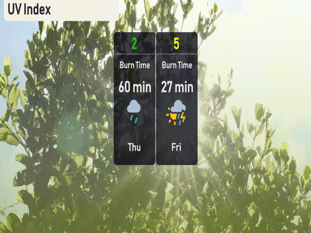
The UV index in Chicago is low today with a rating of 2 due to cloud cover from a storm system, minimizing harmful UV exposure. Tomorrow, the UV index rises to 5 with a burn time of about 27 minutes, so be mindful if you find some sun between clouds. Keep your sun protection handy!
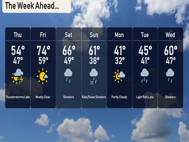
For the 7-day forecast in Chicago:
Thursday: Expect thunderstorms late with a high of 54 degrees and a low of 47.
Friday: Mostly clear skies with temperatures rising to 74 degrees and a low of 59.
Saturday: Showers with a daytime high reaching 66 degrees and a low of 49.
Sunday: Rain and snow showers possible, with a high of 61 degrees and a low of 38.
Monday: Partly cloudy conditions with cooler temperatures, high of 41 degrees and a low of 32.
Tuesday: Light rain expected late in the day with temperatures peaking at 45 degrees, low of 41.
Wednesday: Showers return with a high of 60 degrees and a low of 47.