Weather Whirlwind: A Week of Midwest Moods from Sunny Skies to Storm Alerts
By
Amy Freeze
Dive into our comprehensive Midwest weather forecast from your favorite meteorologist, Amy Freeze. From the sunny heights to the stormy nights, we cover it all!
Stay ahead of the weather! This week’s Midwest forecast has it all from balmy sunny days to chilling cold nights and wary storm alerts. Gear up for an unpredictable week.
Amy Freeze here with your Midwest Forecast, promising a varied climatic scenario across the region. From Chicago’s cooler temps to Kansas City’s heatwave, and looming thunderstorms that may bring about severe weather in areas like St. Louis and Des Moines. Prepare for sudden weather shifts with daily updates and expert tips on coping with these changes.
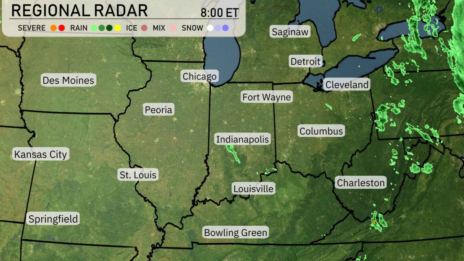
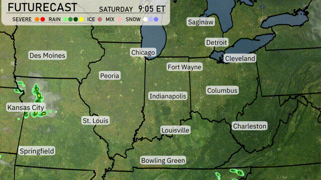
The Midwest radar reveals rain showers crossing into Cleveland and extending into areas like Saginaw and Detroit. Fort Wayne is experiencing scattered light precipitation, as part of a wider cloud cover stretching across parts of Indiana. If you’re in Louisville, expect a chance of light showers potentially sweeping through with the broader band of moisture. Areas like Des Moines and Springfield are enjoying clear skies, a brief respite from the active weather pattern elsewhere in the region.
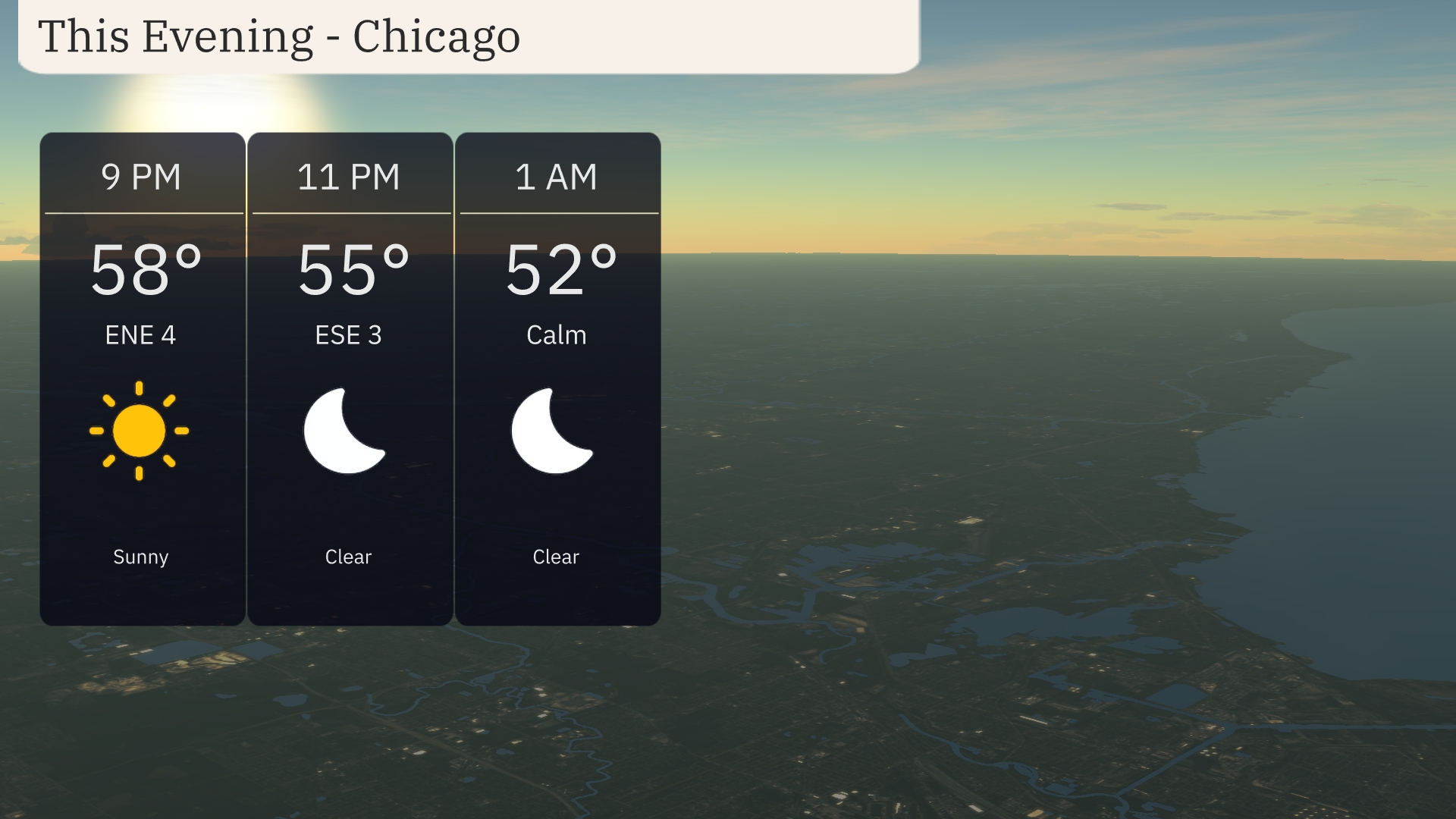
For the evening in Chicago, expect a sunny start as temperatures reach 58 degrees by 9 PM, accompanied by a gentle east-northeast breeze at 4 miles per hour. By 11 PM, the skies will remain clear with temperatures dropping to 55 degrees, and a shift to east-southeast winds at 3 miles per hour. Overnight, calm conditions persist with clear skies and the temperature falling to 52 degrees by 1 AM.
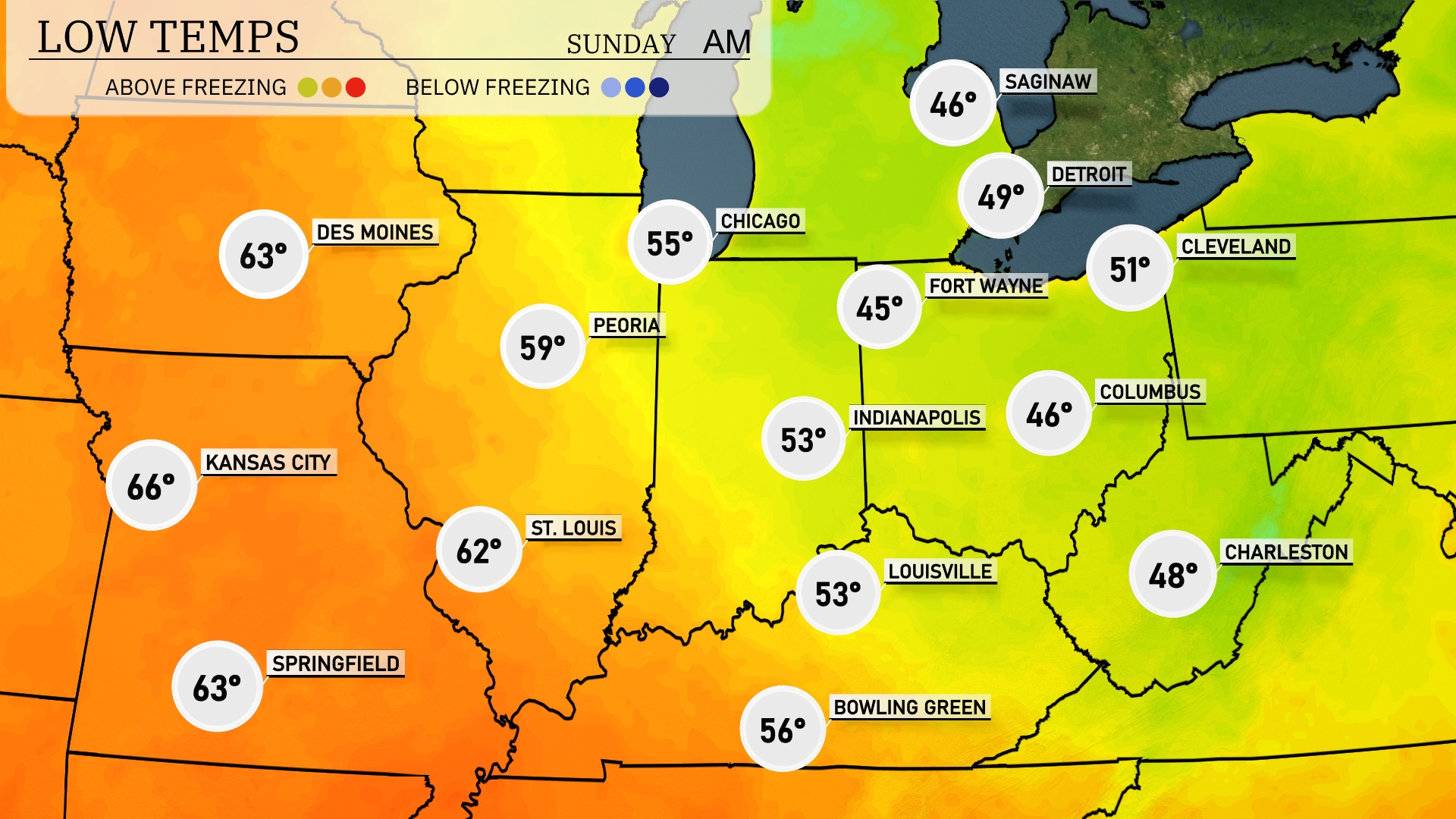
Tonight Chicago will dip to 55 degrees, while Indianapolis will be a bit chillier at 53. Expect lows of 46 in Fort Wayne and Columbus, and a crisp 45 in Indianapolis. Farther north, Saginaw will be the coldest at 46 degrees. Temperatures will remain mild in St. Louis at 62 degrees and Kansas City at 66, but those in the northern reaches should prepare for a chilly night ahead.
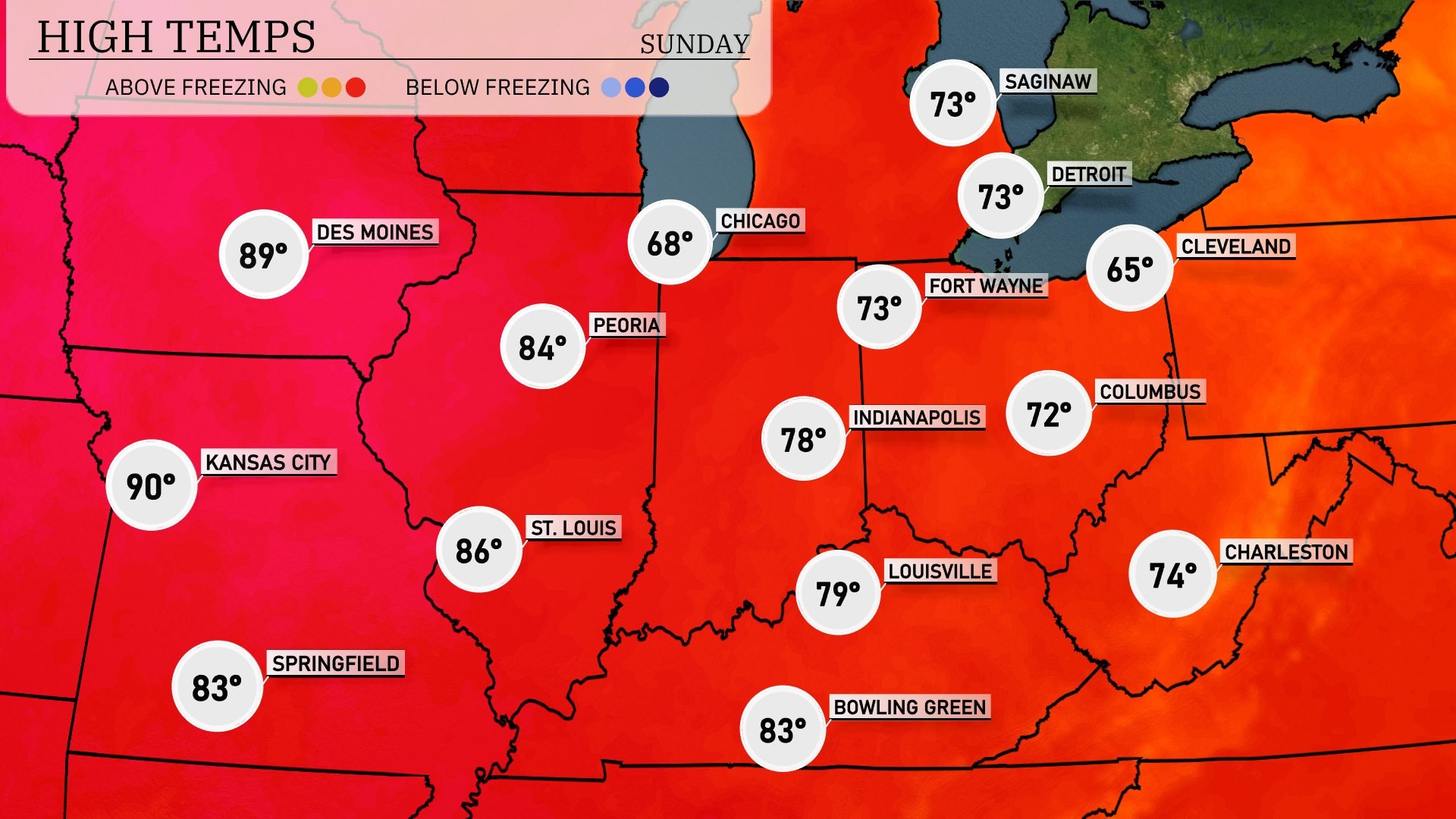
Tomorrow Kansas City leading the way at a sizzling 90 degrees. St. Louis will follow closely with a high of 86, while Peoria will reach 84. Indianapolis and Louisville will see comfortable highs of 78 and 79, respectively. Chicago stays cooler at 68 degrees, significantly below the surrounding averages due to persistent cloud cover.
Expect an active weather scenario across the Midwest tomorrow. A vigorous cold front sweeping in from the west will bring scattered thunderstorms with the potential for severe weather, particularly in Des Moines, Kansas City, and St. Louis. Be prepared for heavy rain, localized flooding, and strong winds during the afternoon into the evening. Temperatures will drop moderately post-front, creating cooler conditions as skies clear towards Friday.
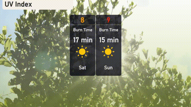
The UV index in Chicago is high on Saturday with a value of 8, leading to a burn time of just 17 minutes under direct sunlight. On Sunday, the UV index climbs even higher to 9, reducing the burn time to a swift 15 minutes.
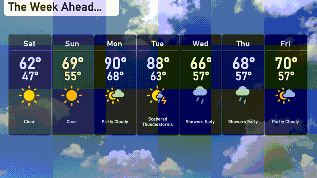
For the 7-day forecast in Chicago:
Saturday: Clear and sunny, with a high of 62 degrees and a low of 47.
Sunday: Another clear day, warming up to 69 degrees with a nighttime low of 55.
Monday: Partly cloudy with a high of 90 degrees and a low of 68.
Tuesday: Scattered thunderstorms expected, reaching a high of 88 degrees and a low of 63.
Wednesday: Showers early in the day, cooler with a high of 66 degrees and a low of 57.
Thursday: More early showers, with temperatures peaking at 68 degrees and dipping to 57 at night.
Friday: Partly cloudy conditions, a high of 70 degrees and a low of 57.