Weather Whirlwind: Amy Freeze Breaks Down This Week’s Midwest Mosaic
By
Amy Freeze
Meteorologist Amy Freeze provides a comprehensive look at the fluctuating weather conditions across the Midwest, from serene sun to stormy showers.
Tap into the dynamic weather landscape of the Midwest with Amy Freeze as she guides you through a week of unpredictable weather, from sunlit afternoons in Chicago to potential storm warnings in the region.
In her detailed analysis, Amy Freeze dissects the complex weather systems affecting the Midwest. With conditions ranging from snowy landscapes in northern cities to looming storms in the south, this week promises dramatic shifts. Understand the highs and lows, both in temperature and atmospheric pressure, with a day-by-day breakdown. Amy also offers safety tips and weather preparedness for upcoming severe conditions, ensuring you stay informed and ready.
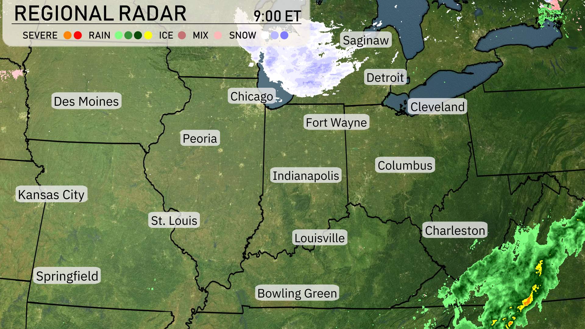
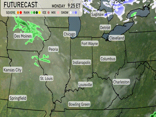
The Midwest radar reveals a mix of weather patterns today. Snow is concentrated in the upper Midwest around Saginaw and stretching across to Fort Wayne. Detroit is also experiencing some snow showers, contributing to wintery conditions there. Farther south, rain is moving through parts of Kentucky, particularly around Bowling Green and nearing Louisville. Indianapolis stands under overcast skies, while Columbus is preparing for potential rain sweeping in from Ohio’s western side. In contrast, cities like Chicago and St. Louis are enjoying clear conditions.
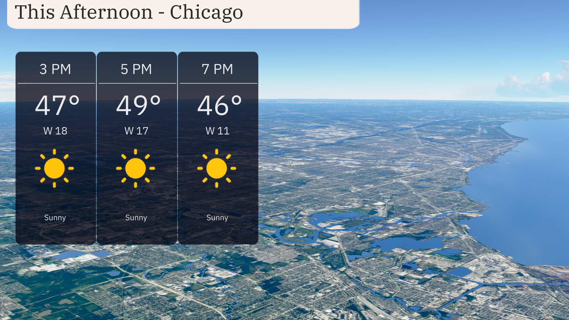
This afternoon in Chicago, temperatures will rise to 49 degrees by 5 PM before cooling to 46 degrees by 7 PM. Enjoy the sun as it dominates the skies, bringing clear conditions. Winds will come from the west, brisk at 18 miles per hour at 3 PM and easing to 11 miles per hour by evening, offering a calm and pleasant afternoon.
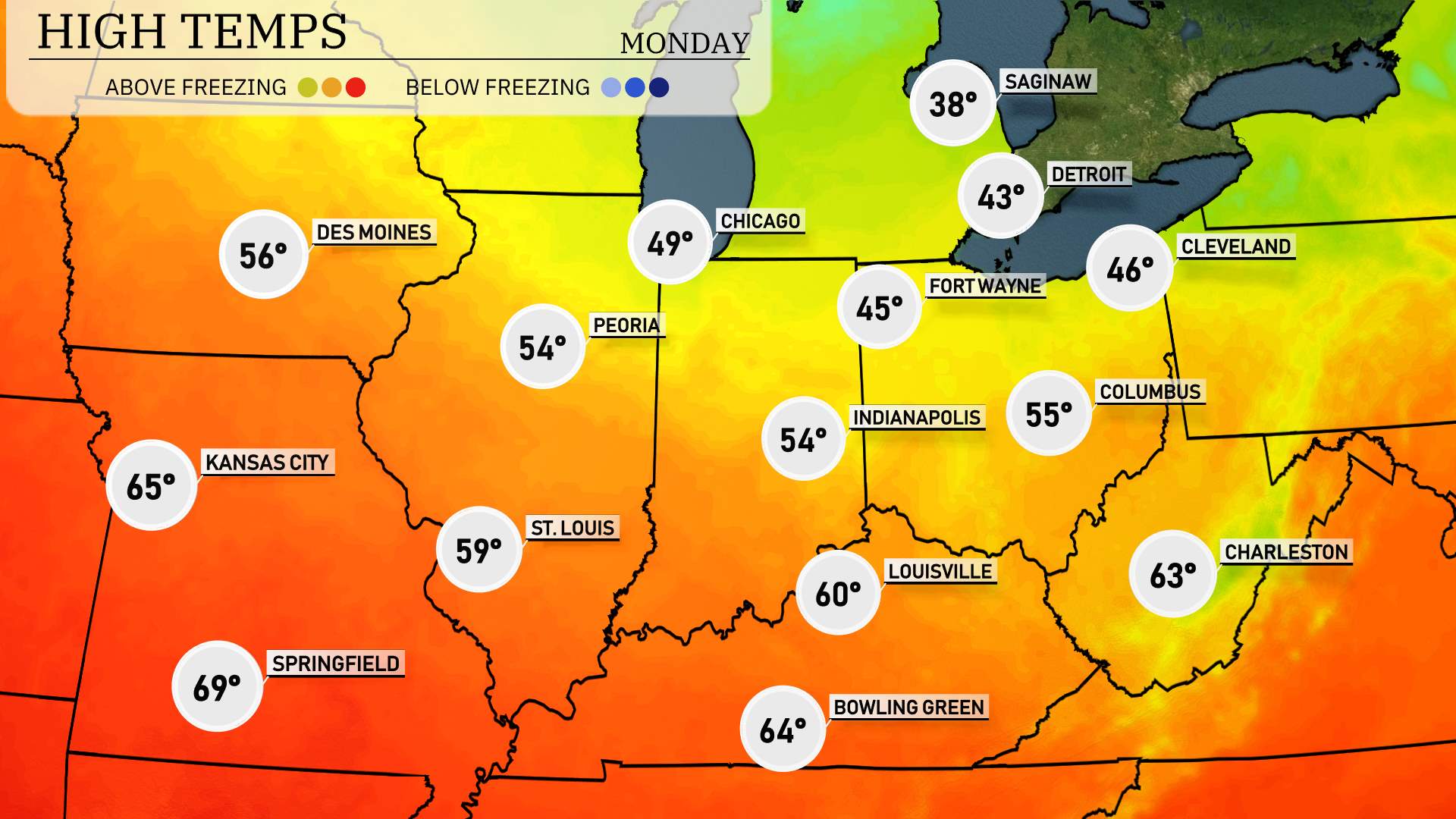
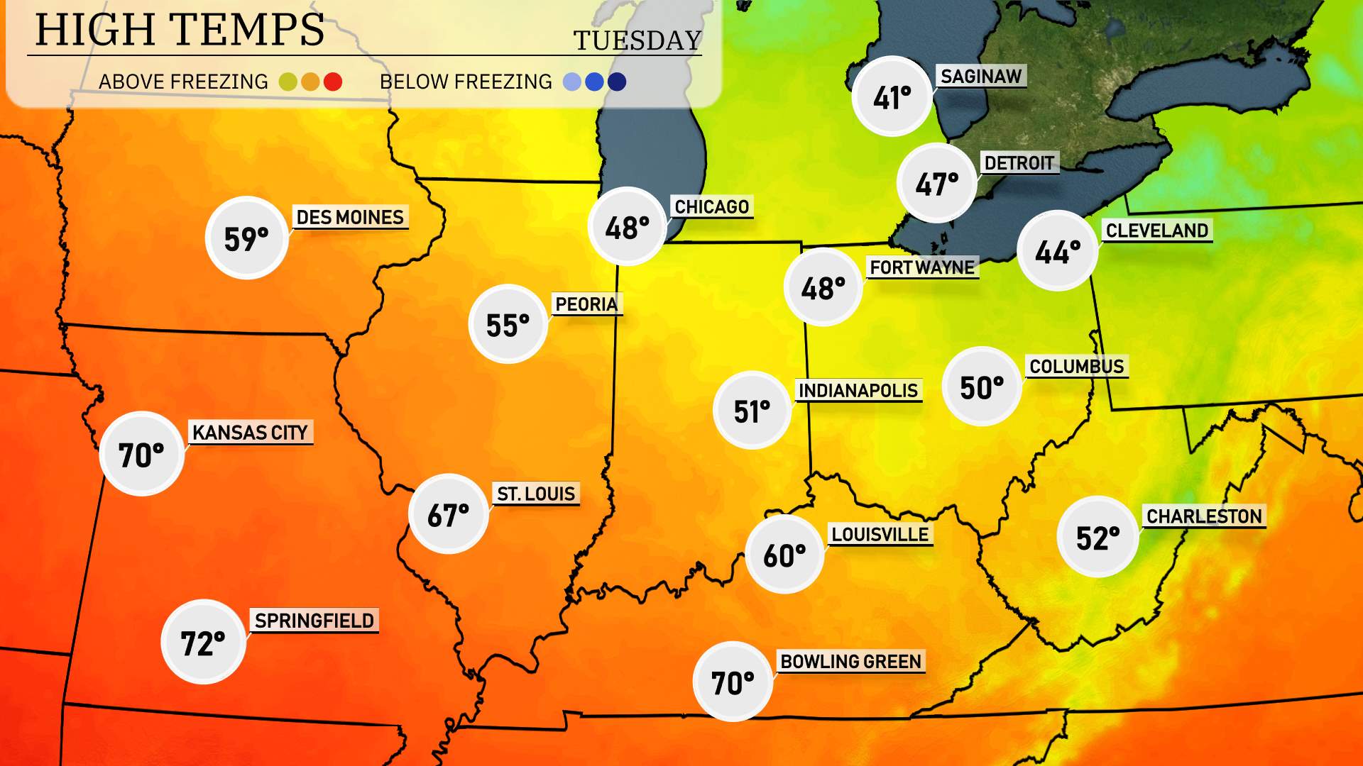
Let’s dive into today’s regional high temperatures across the Midwest.
In the northern part of the region, it’s a cool day in Chicago with a high of 49 degrees and Fort Wayne slightly warmer at 45 degrees. Meanwhile, Indianapolis isn’t far behind with a high of 54 degrees.
Heading south, things start to warm up significantly. St. Louis experiences a pleasant 59 degrees, and Kansas City sees a nice high of 65 degrees. Further south, Bowling Green reaches 64 degrees, while Louisville hits 60 degrees.
Springfield enjoys the warmest temperatures in the Midwest today at 69 degrees.
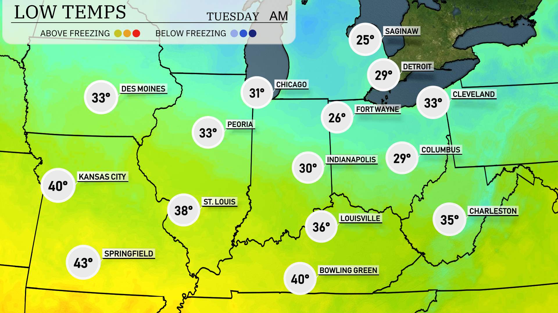
Tonight, the Midwest is gearing up for some chilly temperatures as a cold front pushes through the region. In Chicago, expect a low of 31 degrees, while Peoria will cool down to 33. Indianapolis will see temperatures drop to 30 degrees, and Fort Wayne will shiver with a low of 26. Detroit is forecasted to be even colder at 29 degrees.
Farther south, St. Louis will register a low of 38, while Kansas City experiences a slightly milder 40 degrees. Forties will also be seen in Springfield, with a low of 43. Louisville is looking at 36 degrees, and Charleston can expect a low of 35.
High temperatures for the Midwest region tomorrow are looking quite favorable. In Kansas City, expect a pleasant high of 70 degrees, while St. Louis is set to reach 67 degrees. Moving to Illinois, Peoria will have a high of 55 degrees. Indianapolis will see a slightly cooler day with a high of 51 degrees. In Indiana, Fort Wayne registers at 48 degrees, a bit below average for this time of year.
Springfield is poised to have a warm high of 72 degrees, creating a mild contrast with surrounding areas. Farther south, Louisville reaches 60 degrees, while Bowling Green mirrors Kansas City at 70 degrees. As we analyze these temps, it’s evident that a mild air mass is influencing the region, setting the stage for spring-like conditions.
A dynamic day is ahead for the Midwest with a weather system moving in. Tomorrow, expect scattered rain showers across Des Moines to St. Louis through the afternoon as the front approaches. By evening, the region could potentially face storms from Chicago to Indianapolis. Areas like Fort Wayne and Bowling Green must stay alert for possible severe weather warnings as strong winds and heavy rain may occur. These storms are set to clear out by late Wednesday, ushering in cooler, dry conditions by midweek.
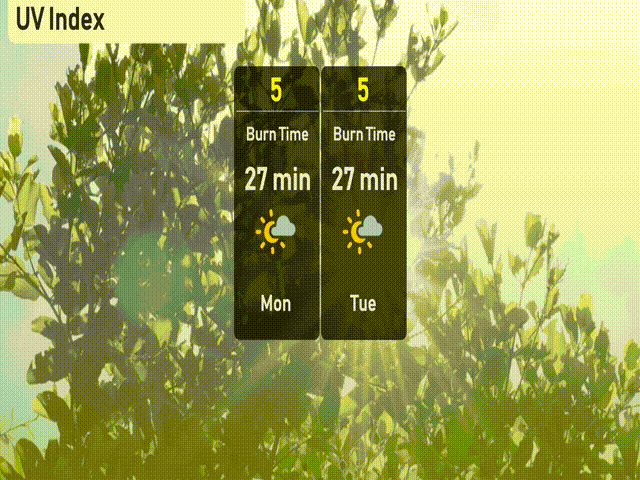
For Chicago, the UV index is moderate at 5 on Monday and Tuesday, with a burn time of about 27 minutes in direct sunlight. Remember to use sunscreen and protective clothing if you’re outside for extended periods.