Midwest Mosaic: A Tapestry of Temperatures and Storms
By
Amy Freeze
Dive into a detailed analysis of this week's fluctuating weather patterns across the Midwest, from chilling winds to stormy skies, with insights from meteorologist Amy Freeze.
Amy Freeze delivers an insightful forecast for the Midwest, featuring a mix of rain, sleet, and cooling temperatures. Learn more about what to expect and how to prepare in our latest blog!
Hello Midwest residents! Meteorologist Amy Freeze here with a detailed look at your week’s weather. Expect a rollercoaster of conditions with everything from sleet to warm breezes. Cities like Chicago, Indianapolis, and St. Louis will see various changes, impacting everything from your wardrobe choices to travel plans. Stay tuned to updates and ensure your safety by following our forecast tips. Read the full story on our official blog: https://amyfreeze.ai/
The Midwest is currently experiencing a diverse range of weather conditions. A significant system is bringing rain and a mix of sleet and snow across the upper Midwest. The radar shows heavier snow activity around Saginaw, possibly impacting local travel with accumulating snow.
Meanwhile, a band of rain is stretching from Kansas City all the way up through St. Louis towards Peoria. This line of showers is moving gradually eastward, likely bringing wet conditions to Springfield and even edging closer to Indianapolis. As the rain moves, expect brief heavy downpours and strong storms are possible.
In the Great Lakes region, areas like Detroit and Cleveland are under widespread rain, with heavier precipitation observed just south of Lake Erie. This rain extends into Columbus, leading to a wet and possibly stormy afternoon in these areas. Farther southeast, Charleston and the surrounding western regions are experiencing intense rainfall, accompanied by some thunderstorms.
Bowling Green is currently seeing a break between the rain bands, providing a brief respite from the showers affecting surrounding regions. Stay weather aware today east of the Mississippi River.
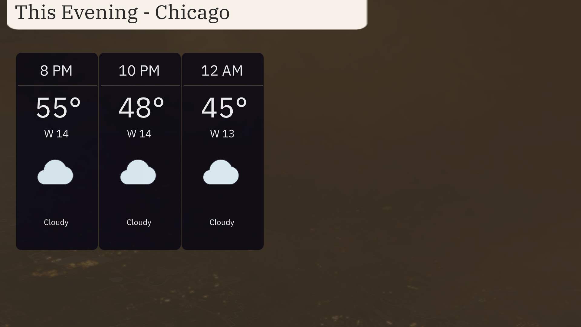
For this evening in Chicago, temperatures will start at 55 degrees at 8 PM, dipping to 45 degrees by midnight. Expect consistent cloudy skies throughout the evening. Winds will maintain a westerly direction, ranging from 14 miles per hour at 8 PM, easing slightly to 13 miles per hour by midnight.
Tonight in the Midwest, expect a notable drop in temperatures as cold air settles into the region. Peoria dips to 33 as well. Indianapolis is looking at a chilly low of 32 degrees, and over in Fort Wayne, it will be a brisk 28. Detroit doesn’t escape the cold either, with an overnight low of 30. Farther south, St. Louis will see 36 degrees, while Kansas City remains slightly warmer at 42. Expect a low of 37 in Louisville and 39 in Bowling Green.
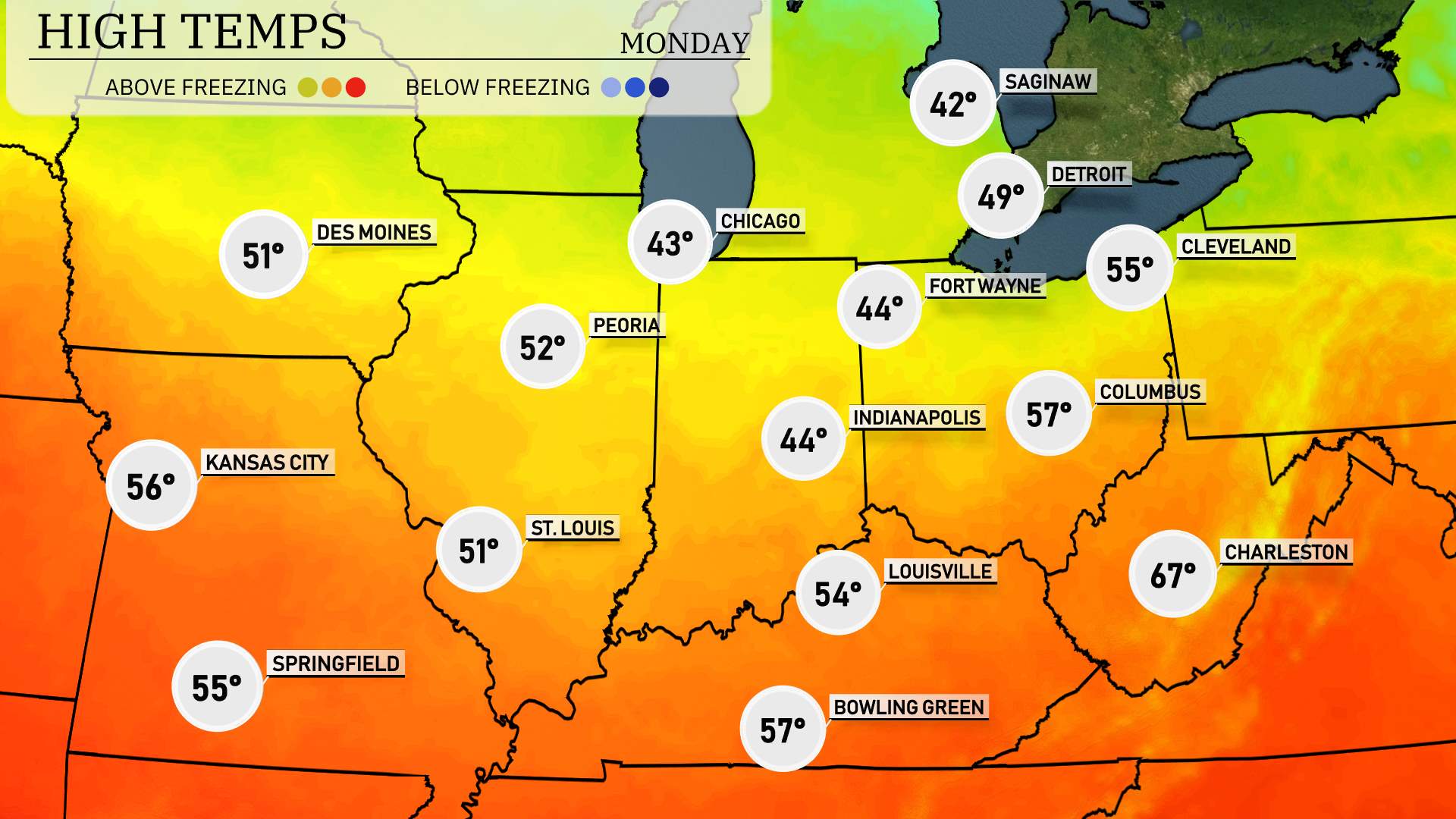
Tomorrow’s high temperatures across the Midwest are looking relatively cool for this time of year, with many cities experiencing below-average readings behind the cold front..
In Indianapolis, expect a chilly 44 degrees.
Fort Wayne is slightly warmer at 44 degrees as well.
St. Louis will have a high of 51 degrees, while Kansas City warms up to 56 degrees.
Peoria is forecasted to reach 52 degrees.
Bowling Green stands out with a higher temperature of 57 degrees, and Louisville closely follows at 54 degrees.
Charleston will get a nice boost, hitting 67 degrees.
“A dynamic weather scenario unfolds across the Midwest as we track a strong line of storms moving eastward. Expect heavy rain and thunderstorms from Des Moines to Louisville by Sunday evening. These conditions bring potential for damaging winds and hail, especially along the frontal boundary. Temperatures ahead of this front are warm but will drop noticeably behind it, bringing more mild conditions into early Monday. Stay alert for weather advisories over the next 24 to 48 hours as this weather system advances farther east.”
The UV index in Chicago is low today, with the storm system blocking harmful rays. Tomorrow, expect a moderate UV index of 5, with a potential burn time of 27 minutes under the sun.
For the 7-day forecast in Chicago:
Sunday: Expect cloudy skies with a high of 69 degrees and a low of 36.
Monday: Look for partly cloudy conditions with a high reaching 43 degrees and a low of 33.
Tuesday: Rain arrives, with temperatures peaking at 45 degrees and dipping to 42 overnight.
Wednesday: Showers early in the day, leading to a warmer afternoon high of 65 degrees and a low of 47.
Thursday: Mostly cloudy with the thermometer hitting a high of 57 degrees and a low around 40.
Friday: Continue with mostly cloudy skies and a high of 48 degrees, cooling down to 40 degrees at night.
Saturday: Mostly cloudy once more, with temperatures reaching a high of 50 degrees and a nighttime low of 38.
Stay safe and enjoy the week ahead!