Weather Whiplash: Midwest Faces a Mix from Snow to Sunshine
By
Amy Freeze
Experience the dramatic shifts in the Midwest weather as Amy Freeze guides you through the varying forecasts, from chilly snowfalls to mild sunny days.
Catch the latest swings in Midwest weather—snowflakes to sunshine—on our blog!
Welcome to a comprehensive look at the Midwest’s ever-changing weather. With a detailed forecast by Amy Freeze, uncover the nuances from city to city, understanding the signs and how to prepare for each day. Explore insights on temperature trends, precipitation patterns, and safety tips during weather transitions.
Across the Midwest, the regional radar is lighting up with a sprawling area of rain stretching from St. Louis through Indianapolis and reaching as far as Charleston. The heaviest showers are currently positioned over Louisville, moving eastward. Northern areas like Fort Wayne and Peoria are seeing lighter showers.
In the northern reaches, including Detroit and Saginaw, conditions are more clear, though Cleveland is encountering a mix of precipitation, including some wet snowflakes that have sparked winter advisories.
Chicago appears to be between systems with milder weather, offering a respite from the wider region’s rain. Springfield and Des Moines are experiencing dry conditions, but showers may be on the way as the day progresses.
Keep your umbrella handy if you’re along the rain corridor, particularly in cities like Bowling Green and Columbus, where rain remains constant this morning.
For this evening in Chicago, expect partly cloudy skies transitioning to clear conditions later in the night. Temperatures will dip from 41 degrees at 9 PM to 39 degrees by midnight, remaining steady. You’ll feel a light southeast wind shifting to south-southeast, then south-southwest, staying around 6 to 7 miles per hour. Stay cozy if you’re heading out!
In Chicago, expect a chilly low of 27 degrees. Des Moines will drop to 25 degrees, and Indianapolis isn’t far behind at 25 degrees as well. St. Louis will see lows around 28 degrees, while Kansas City will cool down to 30 degrees. In Louisville, temperatures will reach 28 degrees, and further to the northeast, Cleveland will sit at 28 degrees. The coldest spot in the region appears to be Fort Wayne, where temperatures will dip to 23 degrees.
In Chicago, expect a high reaching 54 degrees, significantly warmer than the seasonal average. Indianapolis will warm up to 55 degrees as well, enjoying similar conditions.
Meanwhile, further south in St. Louis, temperatures could peak at 61 degrees, while Kansas City will see a high of 57 degrees, both above normal for this time of year.
To the east, Louisville could experience a high of 57 degrees, and Columbus is forecasted for 55 degrees.
Overall, a warm front moving through the region is contributing to these above-average temperatures, providing a welcome shift as we start to feel the rhythm of spring.
Expect an active weather day across the Midwest with a mix of winter and spring conditions. A cold front brings widespread rain showers stretching from St. Louis to Cleveland, gradually moving south and east through tomorrow. Indianapolis may see a transition from rain to snow showers overnight, though accumulations are expected to be minor. Areas north of Columbus and south of Fort Wayne could face a mix of ice and snow, leading to potentially tricky travel conditions, particularly around Fort Wayne this evening.
Temperatures will hover above freezing southward, but expect a cooler, more mild trend as the rain persists into the early hours of Tuesday. Keep a close watch for any severe weather warnings, particularly in southern Indiana and Ohio as the system moves through. The southern part of the region, including Bowling Green and Charleston, should prepare for the potential of heavy rain, which may cause localized flooding, especially along waterlogged roads and low-lying areas. Stay informed and travel with caution.
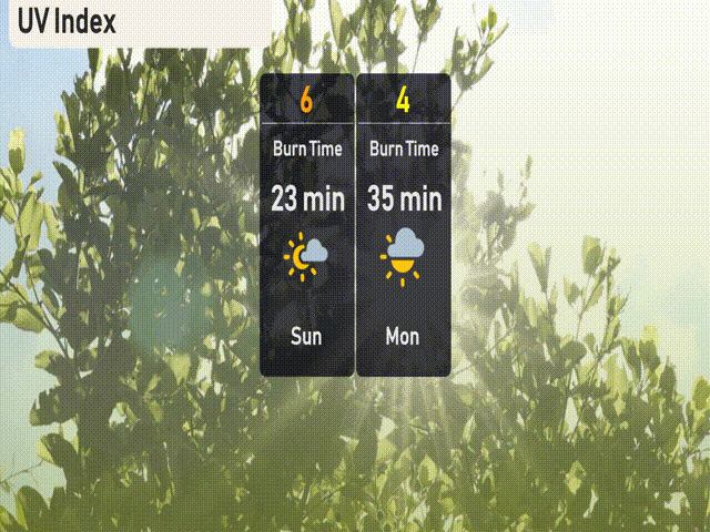
The UV index in Chicago for Sunday is a strong 6, with a burn time of about 23 minutes in direct sunlight. On Monday, it decreases to a moderate level of 4, with a burn time of 35 minutes.
For the 7-day forecast in Chicago:
Sunday: Partly cloudy with a high of 46 degrees and a low of 37.
Monday: Colder temperatures expected with a high of 39 degrees, dipping to a brisk 26 degrees at night.
Tuesday: Mostly cloudy skies, reaching 40 degrees for the day and dropping to 32 in the evening.
Wednesday: Rain showers anticipated throughout the day with a high of 43 degrees, cooling to 37 degrees overnight.
Thursday: Enjoy partly cloudy conditions with daytime temperatures around 45 degrees and a low of 36.
Friday: The sun peeks through with a high reaching 51 degrees and a nighttime low of 37.
Saturday: Partly cloudy skies with the week’s warmest high of 55 degrees and a low of 41.
Stay safe and enjoy the changing weather!