Storm Watch: Amy Freeze’s Insightful Forecast for Chicago and Beyond
By
Amy Freeze
Explore the dynamic weather landscape as Amy Freeze provides an expert analysis on the Midwest's incoming storm system, temperature variations, and what to expect over the next week.
Meteorologist Amy Freeze brings you the latest weather conditions for Chicago and the Midwest including storm forecasts, temperature shifts, and safety precautions.
With a focus on Chicago and the greater Midwest, Amy Freeze analyzes a line of storms moving through, creating potential thunderstorms and heavy rain. From morning temperatures to nightly lows across the Midwest, and a detailed 7-day outlook, stay informed on what these changes could mean for your area. Safety tips and weather preparedness are also covered.
On the regional radar, a dynamic weather system is affecting the Midwest region. A line of storms is currently moving from Kansas City towards St. Louis, bringing heavy rain and possible thunderstorms. Springfield is experiencing rain, which is advancing northeast towards Peoria. Chicago and Fort Wayne are under thick cloud cover, suggesting possible light rain to showers as the system progresses. Farther east, cities like Detroit and Cleveland remain relatively clear at the moment, although cloud cover is increasing. Indianapolis and Louisville are beginning to see showers moving in from the west, which may intensify as the front approaches. The rest of the region, including cities like Saginaw and Columbus, can expect increasing clouds as the day progresses.
Tomorrow morning in Chicago, temperatures start at 48 degrees at 7 a.m. with a chance of scattered thunderstorms. Winds are coming from the south at 8 miles per hour. By 9 a.m., temperatures climb to 53 degrees with cloudy skies and a south-southwest wind at 10 miles per hour. As the morning progresses, expect the temperature to reach 60 degrees by 11 a.m., while the south-southwest wind picks up to 14 miles per hour, maintaining cloudy skies.
High temperatures across the Midwest for tomorrow are expected to be notably warm for this time of year. Kansas City is set to reach 78 degrees, experiencing a pleasant trend. Peoria anticipates a similar high at 79 degrees, while St. Louis will edge slightly higher at 81 degrees as well.
Farther east, Indianapolis expects a comfortable 77 degrees, with Louisville also hitting 79 degrees. Columbus will see a high around 72 degrees, while the colder air to the north keeps Detroit at a cooler 63 degrees.
“Across the Midwest tomorrow, expect scattered rain showers impacting cities from St. Louis to Cleveland, with Chicago and Indianapolis likely seeing some heavier downpours. Watch out for localized flooding in low-lying areas, as the rain persists into the afternoon. Temperatures will remain mild, ranging from the upper 50s to mid-60s. An approaching cold front will move from the west, possibly bringing isolated thunderstorms in areas farther east towards Bowling Green and Louisville.”
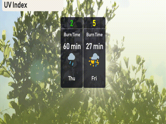
The UV index in Chicago is low today and will not be significant due to the storm system in the area. Tomorrow’s UV index rises to moderate at 5.
For the 7 Day Outlook in Chicago:
Friday: Thunderstorms arriving late with a high of 74 degrees and a low of 58.
Saturday: Expect partly cloudy skies with some windy conditions, the temperature drops to a high of 65 degrees and a low of 48.
Sunday: Showers are likely, with a high of 61 degrees and a low of 37.
Monday: Rain and snow showers mix, temperatures cool further to a high of 40 degrees and a low of 32.
Tuesday: Partly cloudy with a high of 46 degrees and a low of 41.
Wednesday: Light rain develops late in the day with a high of 60 degrees and a low of 45.
Thursday: More showers expected, cooling down with a high of 55 degrees and a low of 43.