Midwest Mosaic: Weather Patterns Sweep Across Chicago and Beyond
By
Amy Freeze
Explore the ebb and flow of weather from gentle Chicago breezes to severe Midwest storms. A close look at what makes this week uniquely challenging and vibrant.
This week, Chicago and the Midwest brace for a dynamic weather shift, featuring everything from sunny days to severe storms. Get insights into daily temperature swings and storm predictions.
As we navigate through another Midwest summer, the weather continues to mesmerize and challenge us. This detailed post delves into the complexities of Chicago’s weather patterns and forecasts the impact of ongoing meteorological phenomena across the region. From daily temperature updates to severe storm tracking, every element is covered to provide you with the information you need to stay prepared. With expert insights and the latest data, understand how these patterns influence life in the Midwest. Check out the full story at [Amy Freeze’s Weather Insights](https://amyfreeze.ai/).
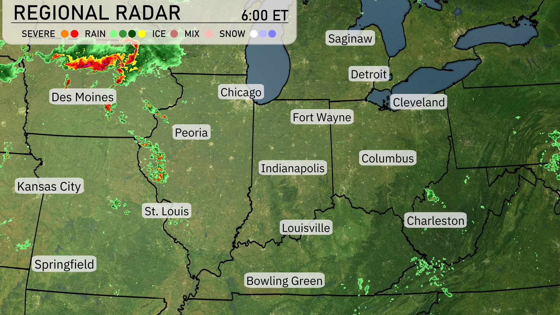
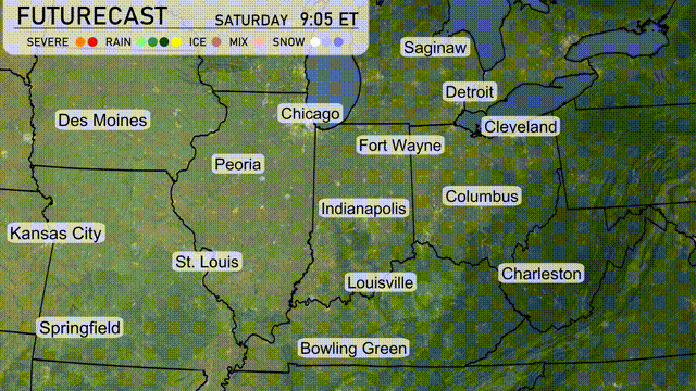
The Midwest radar shows a strong line of storms currently stretching across eastern Iowa, impacting areas like Des Moines and moving southeastward towards Peoria. Heavy rain accompanied by severe weather is progressing, bringing strong thunderstorms along this path. Meanwhile, isolated showers are touching regions near St. Louis, while the Great Lakes cities such as Detroit and Cleveland enjoy clear skies. Columbus and Charleston are experiencing some light rain showers moving eastward.
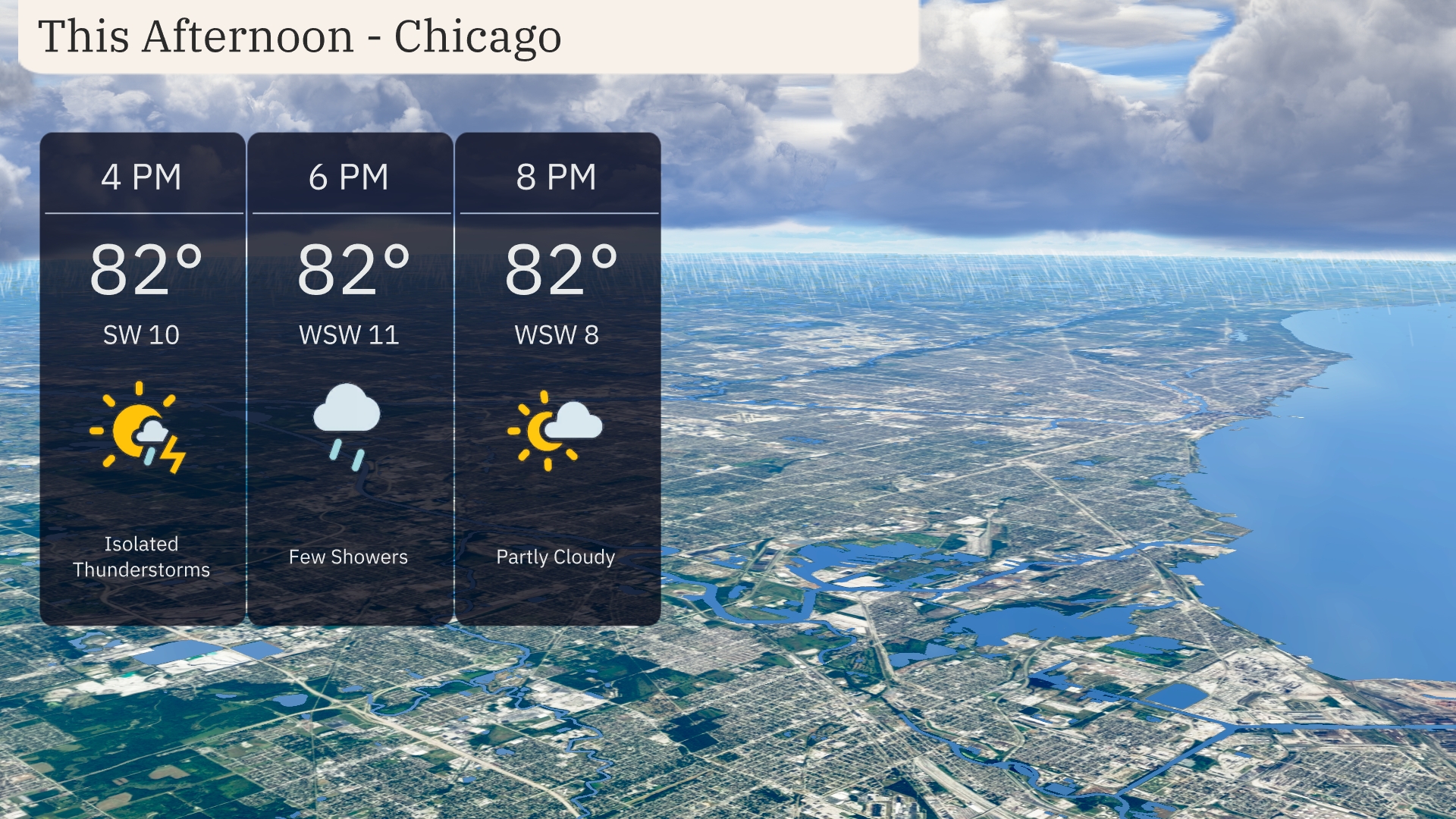
Expect isolated thunderstorms this afternoon in Chicago, starting at 4 PM with temperatures reaching 82 degrees. Winds will be coming from the southwest at 10 miles per hour. By 6 PM, showers will continue with a slight wind shift to west-southwest at 11 miles per hour. Cloud cover decreases by 8 PM, as skies become partly cloudy and winds ease to west-southwest at 8 miles per hour, while temperatures hold steady at 82 degrees.
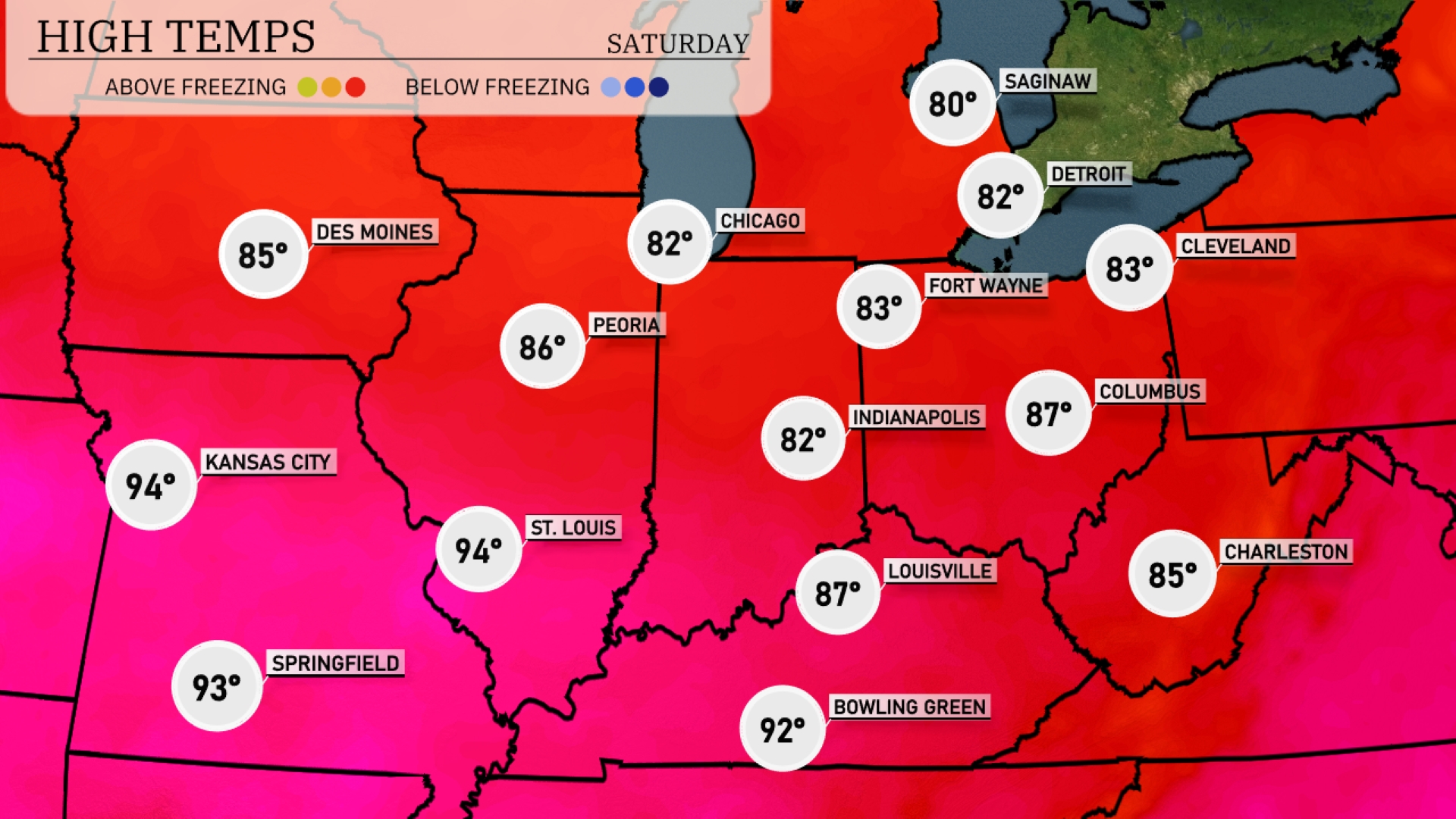
Today, the Midwest is seeing some warm temperatures across the region. Kansas City and St. Louis stand out with highs of 94 degrees, while Des Moines is slightly cooler at 85. In Indiana, Indianapolis reaches 82 degrees, while Fort Wayne is just a degree warmer at 83. The contrast continues with Columbus hitting 87 degrees and Louisville warming up to 87 as well. Over in Michigan, Detroit will see a high of 82, making for a pleasant summer day.
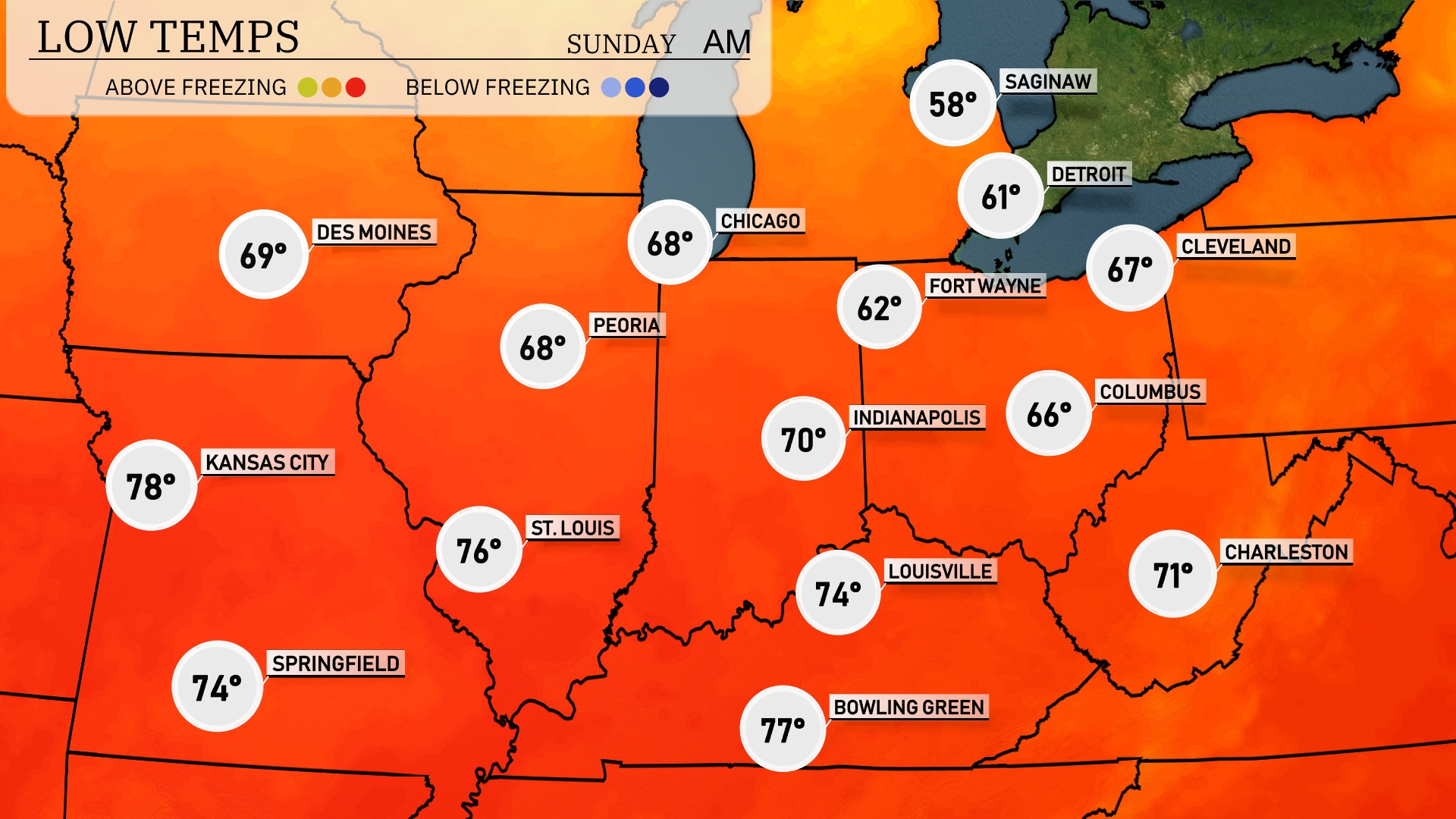
Tonight, temperatures in the Midwest will remain warm, but a few cities will see notable drops. Expect a low of 62 degrees in Fort Wayne, while Indianapolis cools to 70. Chicago will have a low of 68, and Peoria will also experience a mild night at 68. Kansas City will stay warm with a low of 78 degrees.
Tomorrow in the Midwest, we’re tracking some sizzling highs. Kansas City leads the way at 96 degrees, closely followed by St. Louis hitting 97. In Illinois, Springfield will see a high of 95, while Peoria reaches 82. Indianapolis and Louisville are looking at 85 and 91 degrees, respectively, with Columbus checking in at 82. These temperatures are significantly above average for this time of year, fueled by a strong high-pressure system dominating the region.
Expect a dynamic day in the Midwest with a frontal passage moving eastward. As it progresses, scattered storms are likely from Kansas City to Chicago, with the strongest activity expected in the afternoon. Be prepared for heavy rainfall and gusty winds, particularly in areas from Des Moines to Indianapolis. Temperatures will start warm but drop noticeably as the front clears. While severe weather threats are moderate, stay alert for localized flooding due to intense downpours.
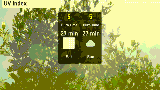
The UV index in Chicago on Saturday and Sunday is moderate at a level of 5, with a burn time of approximately 27 minutes in direct sunlight. Make sure to protect your skin with sunscreen and take breaks in the shade if you’re out enjoying the weekend!