Midwest Weather Scoop: Chicago’s Cool Spell and Rain Outlook
By
Amy Freeze
Dive into our comprehensive weather forecast with Amy Freeze, featuring a special look at Chicago's partly cloudy skies and the anticipated regional temperature shifts. Stay tuned for daily updates!
Explore the weather dynamics from Chicago to the broader Midwest. Learn about the rain predictions, temperature trends, and how to plan your week with Amy Freeze’s insights.
In Chicago, the afternoons are turning pleasant with partly cloudy skies, setting the scene for outdoor activities. However, keep the umbrella close as rain is around the corner. Dive deeper into the Midwest’s temperature variations and expected rainfalls with forecasts for cities like Kansas City, Indianapolis, and Detroit. Stay ahead of the weather with daily updates from meteorologist Amy Freeze.
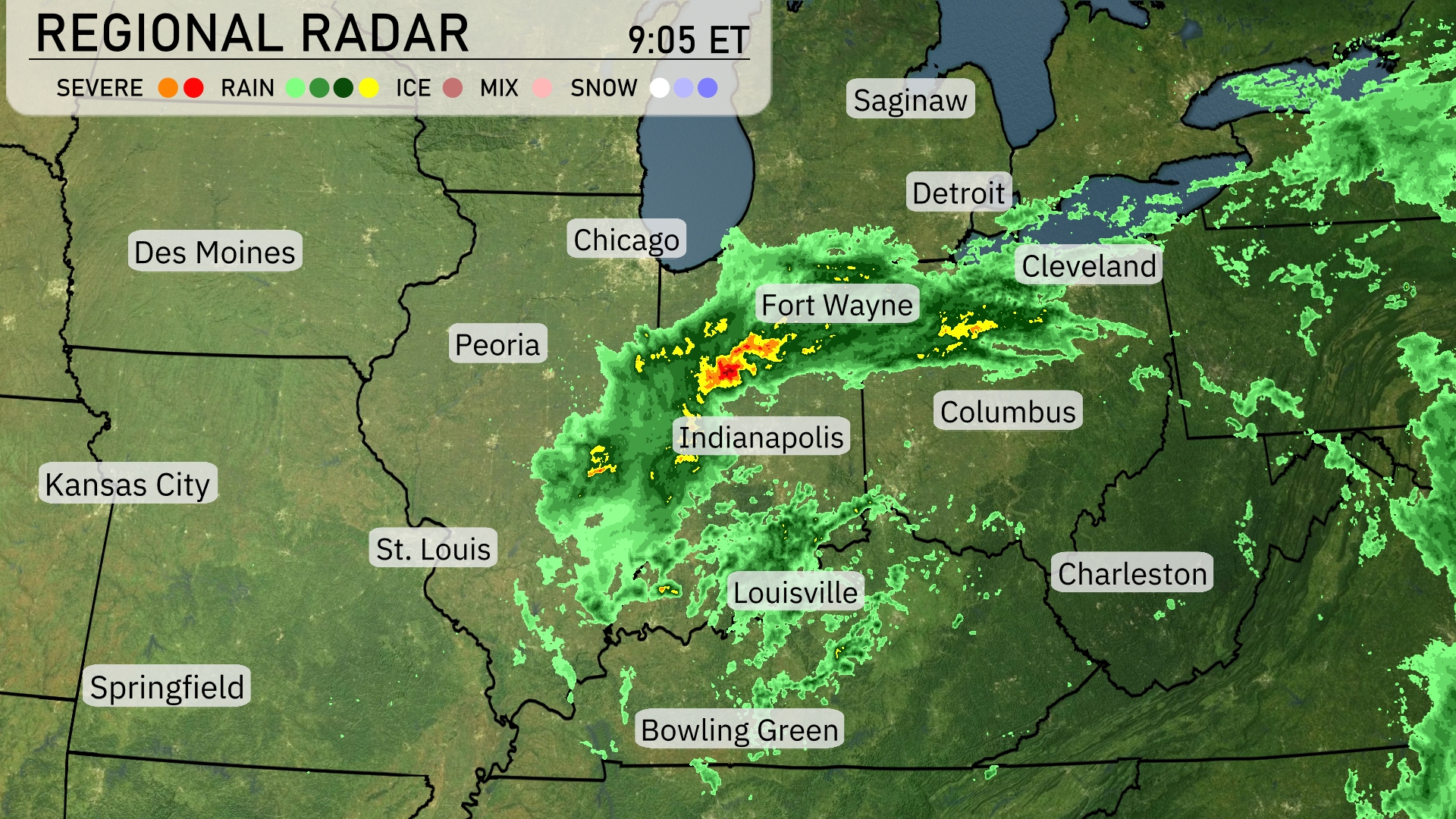
A line of heavy rain, accompanied by embedded thunderstorms, is sweeping across Indiana, stretching from Indianapolis to Fort Wayne. This band of precipitation is heading towards western Ohio, bringing rain to cities like Dayton and Columbus. Moderate rain extends south into Kentucky, impacting areas like Bowling Green and north towards the Great Lakes with some lighter showers reaching Detroit. Over in Illinois, Chicago is experiencing lighter rain showers, with more significant precipitation just to its east. Des Moines and St. Louis remain free of precipitation, with partly cloudy skies prevailing in these areas.
In Chicago this afternoon, temperatures will start at 50 degrees around 4 PM, with a north-northeast wind blowing at 16 miles per hour. Rain is expected, becoming lighter by 6 PM as temperatures ease to 49 degrees with winds around 14 miles per hour. By 8 PM, expect scattered showers, with temperatures slightly dropping to 48 degrees and winds calming to 13 miles per hour.
In the Midwest today, we’re seeing quite a spread in high temperatures. Kansas City is warming up to a comfortable 71 degrees, while St. Louis will reach 61. Over in Peoria, we’re expecting a high of 60 degrees, and Indianapolis will see a chilly 51. Chicago is struggling to hit 51 as well, compared to Fort Wayne, which is slightly cooler at 49 degrees. Columbus is enjoying a warmer afternoon at 63 degrees, and Charleston is looking pleasant with a high of 68. This temperature variation highlights the cool air lingering over the northern parts of the Midwest while the southern areas enjoy milder conditions.
Low temperatures tonight in the Midwest will be on the cooler side, with several areas dipping down into the upper 40s. Expect 46 degrees in St. Louis and 47 in both Chicago and Des Moines. Indianapolis will see a low of 50, while Kansas City will be slightly warmer at 51. Fort Wayne and Detroit will both rest at 53 degrees.
Tomorrow, the Midwest will experience above-average temperatures as a warm front moves through the region. Kansas City is expected to hit a high of 75 degrees, while St. Louis will reach 71. Des Moines is forecasted at 73 degrees, indicating a pleasant day ahead. Meanwhile, Chicago will be cooler at 56 degrees, and Indianapolis sees a high of 61, slightly below the seasonal average.
A low-pressure system will bring showers and thunderstorms to the Midwest tomorrow. Expect scattered rainfall across Indianapolis and into Louisville, with heavier pockets possible in areas like Columbus and Fort Wayne, which might lead to localized flooding. Temperatures will remain mild as the system moves through, though cooler air is set to follow. Watch for stormy conditions over Detroit and Chicago, with the potential for gusty winds. A clearing trend begins late tomorrow as the system advances eastward, bringing drier conditions into the midweek.
The UV index in Chicago will be a moderate 4 both today and tomorrow, with potential sun exposure risks leading to a burn time of about 35 minutes.