Thunderstorms on the Horizon: Brace for Midwest Weather Shifts
By
Amy Freeze
Explore our detailed analysis of the upcoming weather shifts across Chicago and the broader Midwest - scorching heat, thunderstorms, and everything in between.
As Chicago gears up to tackle up to 89 degrees today, ominous thunderstorms approach. Stay updated and prepared with our latest forecasts and expert tips.
With a UV index of 8 and scorching temperatures around Chicago, the city is aiming for a high of 85 degrees. But it’s not just the heat; a line of potent thunderstorms is expected to sweep across the Midwest, beginning tonight. Expect storms capable of heavy downpours and localized flooding, especially in Peoria and Indianapolis. Read our full report to navigate through these changes smoothly and safely with expert tips and frequent updates.
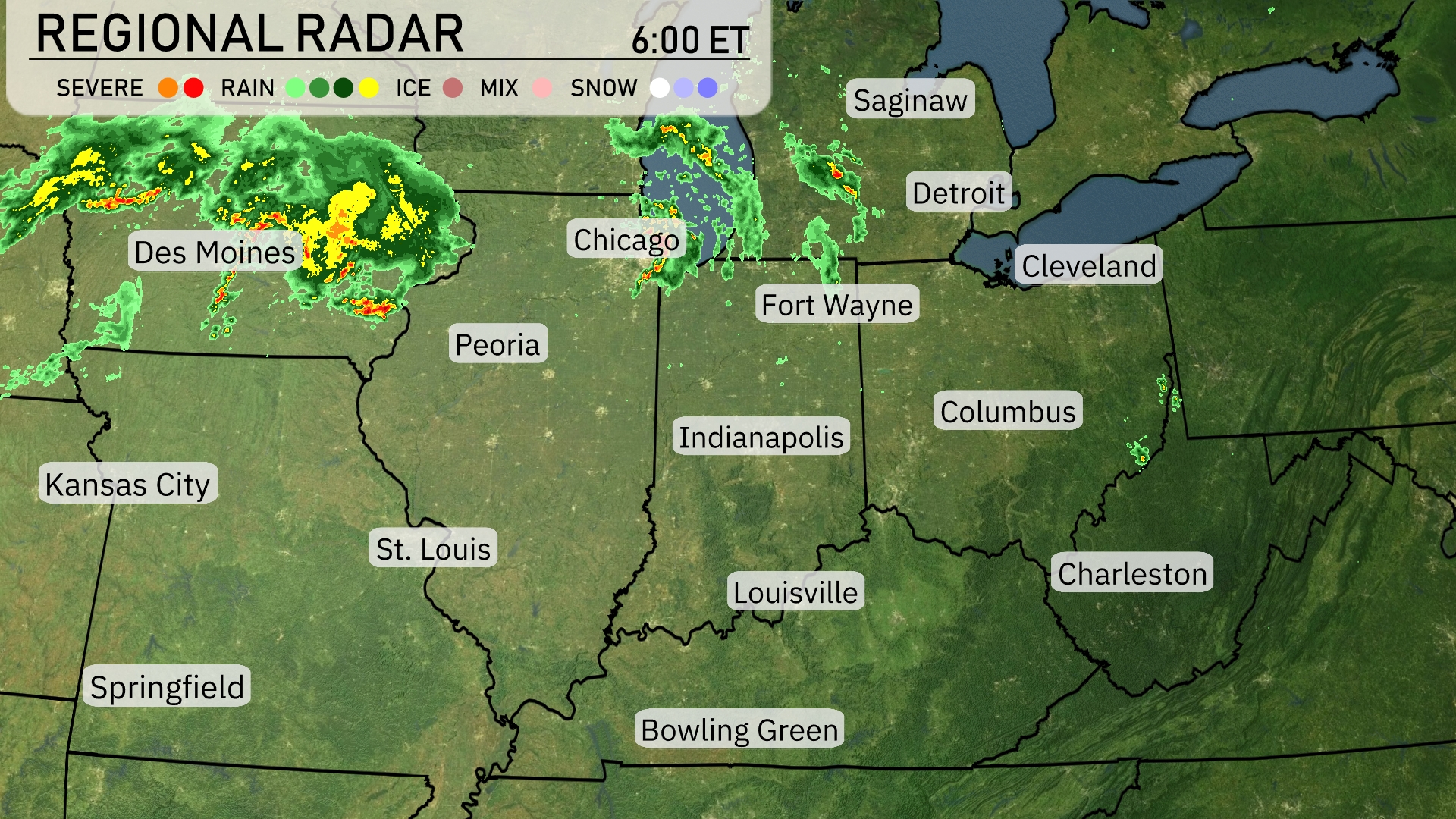
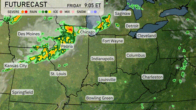
Strong storms are sweeping through Iowa, notably around Des Moines, moving towards Chicago. Peoria also sees pockets of heavy precipitation as the rain advances eastward. Rain is making its way into the Great Lakes region, with Fort Wayne and Detroit experiencing light showers. Southern Illinois, Ohio, and parts of Kentucky are currently under clear skies, enjoying calm conditions.
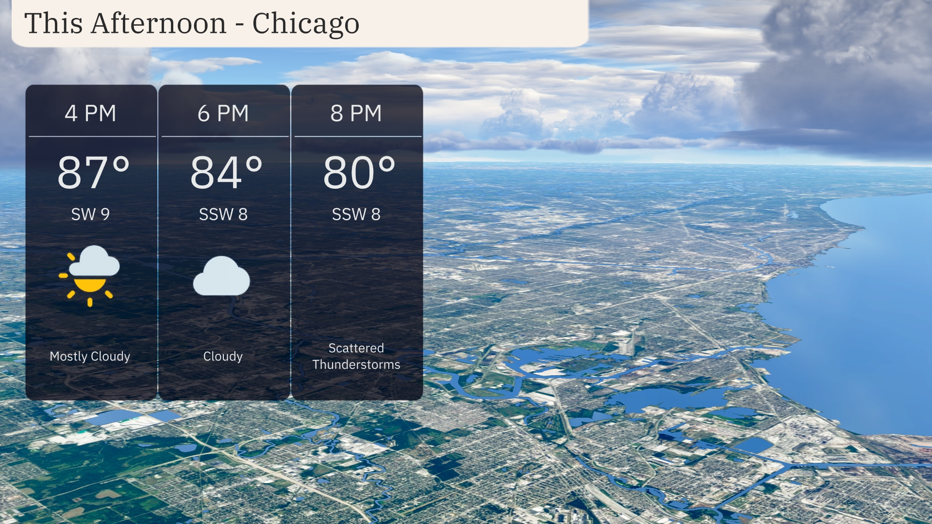
Temperatures in Chicago this afternoon are reaching up to 87 degrees with a southwesterly wind at 9 mph. By 6 PM, expect cloud cover to increase as temperatures dip slightly to 84 degrees, with winds turning to the south-southwest at 8 mph. Later in the evening, scattered thunderstorms are likely, bringing temperatures down to around 80 degrees with continued south-southwest winds.
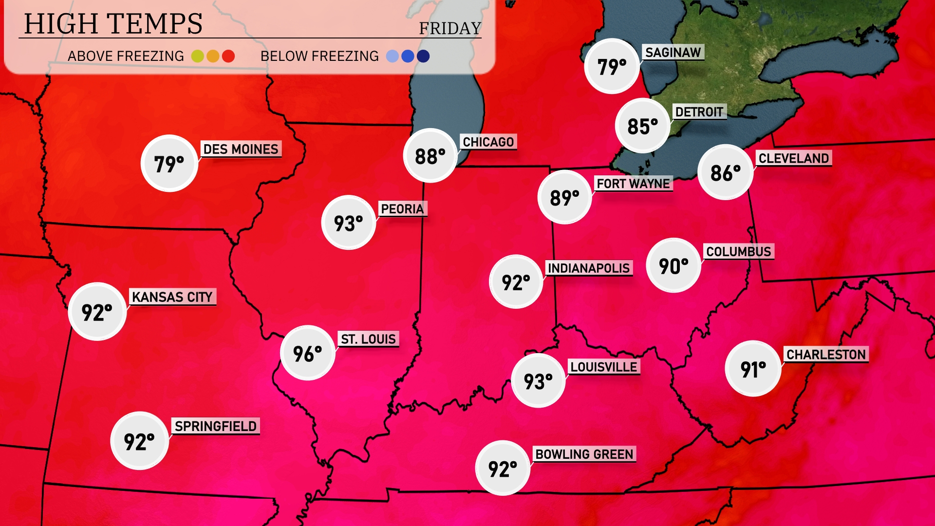
In the Midwest today, Des Moines reaches a pleasant high of 79 degrees, while Kansas City is warmer at 92. Chicago experiences a steamy day with a high of 88, and St. Louis is on the hotter side, hitting 96 degrees. Indianapolis sees a high of 89, closely followed by Columbus at 90. Fort Wayne is slightly cooler at 89, providing some relief from the intense heat that’s dominating the region.
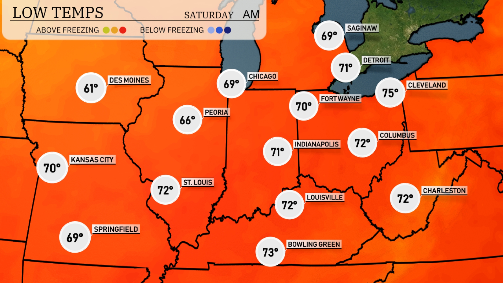
Tonight in the Midwest, expect lows around 61 degrees in Des Moines and a mild 70 in Kansas City. Chicago will dip to 69 degrees, while Indianapolis is forecasted to see a low of 71. Peoria will cool down to 66 degrees, with St. Louis holding steady at 72.
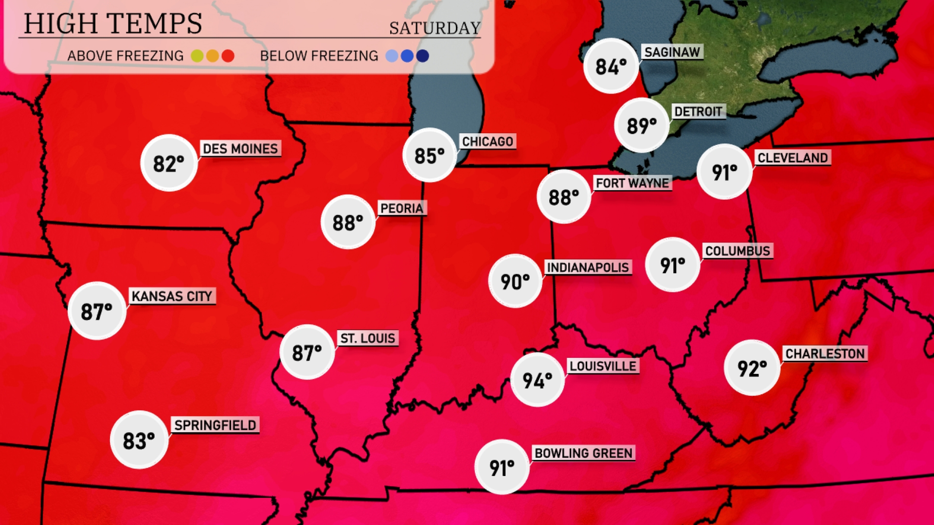
Tomorrow in the Midwest, expect sizzling temperatures as Chicago hits 85 degrees. Indianapolis will reach a warm 90 degrees, with nearby Louisville warming up to a steamy 94 degrees. Kansas City is looking at a high of 87 degrees, while Peoria will see 88 degrees.
A line of thunderstorms is poised to advance into the Midwest, starting tonight near Des Moines and sweeping through Chicago by early Friday morning. With this frontal system, expect strong thunderstorms capable of producing brief heavy downpours and gusty winds, particularly over areas like Peoria and Indianapolis. As the system continues eastward, keep an eye out for potential localized flooding due to heavy rainfall, especially in low-lying areas. Daytime temperatures across cities like Detroit and Cleveland remain mild under cloudy skies. Watch for developing weather alerts and stay informed as the system progresses eastward into Friday evening.
The UV index in Chicago is high today with a value of 8, presenting a burn time of about 17 minutes in direct sunlight. Expect similar conditions tomorrow with another UV index of 8.