Chilly Winds and Rain: Your Midwest Weather Update with Amy Freeze
By
Amy Freeze
Meteorologist Amy Freeze provides a comprehensive look at the shifting weather patterns across the Midwest, from cold fronts to sunny highs. Stay informed with our detailed forecast.
Catch the latest weather trends and forecasts across the Midwest. Amy Freeze guides you through upcoming changes, including temperature dips and rain predictions.
As the skies over Chicago show partly cloudy conditions tonight, a line of rain is advancing through the Midwest impacting cities from Springfield to St. Louis. We’re seeing a temperature range in major cities, warming up nicely in some parts while cooling in others. A cold front will bring scattered showers and possible thunderstorms tomorrow. Dive deeper into our comprehensive 7-day forecast for Chicago and tips on how to prepare for the weather shifts.
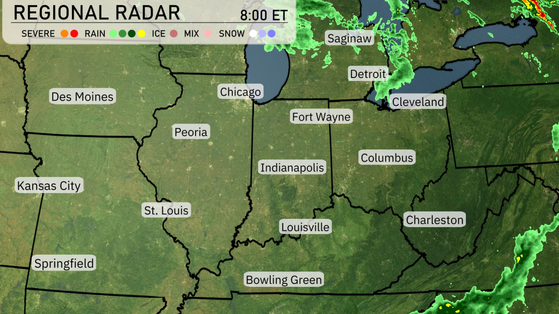
A line of rain is advancing through the Midwest, with precipitation moving into Springfield and heading towards St. Louis. Chicago is currently under cloudy skies but is expected to see rain arriving soon. In the Great Lakes region, clouds are thickening from Saginaw to Detroit, signaling approaching wet weather. Fort Wayne and Cleveland are experiencing overcast conditions with a light drizzle in some areas. By the time this system reaches Bowling Green, expect sporadic showers possibly extending toward Charleston later in the day.
For this evening in Chicago, temperatures will dip from 63 to 57 degrees by 1 AM. The wind will remain steady, coming from the west-northwest at 14 miles per hour, decreasing slightly through the night. Expect the sky to be mostly cloudy at 9 PM, becoming partly cloudy by 11 PM, and mostly clear as the night progresses.
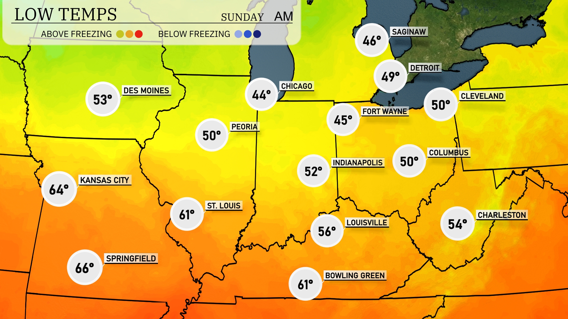
The Midwest will experience a drop in temperatures tonight as cold air settles in. Chicago is forecasted to drop to 44 degrees, while Indianapolis will see a low of 52. Fort Wayne and Detroit are expected to reach chilly lows of 45 and 49 degrees, respectively. Meanwhile, Louisville will stay warmer at 56 degrees, but it’s a significant cooldown compared to yesterday.
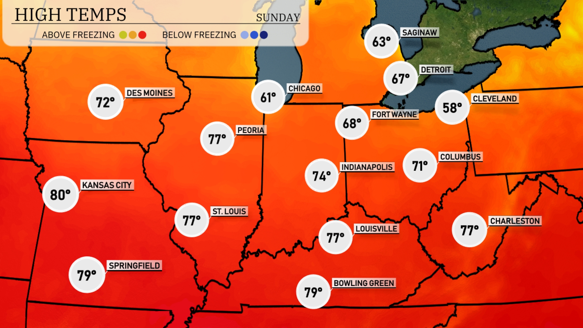
Tomorrow’s high temperatures across the Midwest indicate a warm trend, with several cities stretching into the upper 70s and even hitting the 80s. Kansas City is forecasted to reach a warm 80 degrees, while St. Louis and Peoria both register highs of 77 degrees. Indianapolis will see a comfortable high of 74 degrees, with Louisville and Charleston also approaching 77. Cooler weather is expected in Chicago at 61 degrees and Fort Wayne at 68 degrees.
A cold front is set to move across the Midwest tomorrow, bringing a notable shift in weather conditions. Expect scattered showers and thunderstorms developing late in the afternoon from Des Moines to Indianapolis, with the potential for strong winds and localized heavy rainfall. Temperatures will drop behind the front, resulting in cooler and drier conditions by Friday evening. Areas like Louisville and Columbus should prepare for a sharp decline in temperatures overnight.
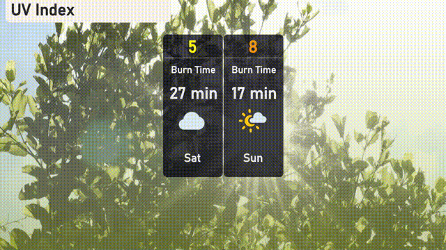
The UV index in Chicago for Saturday is at a moderate level of 5, with a burn time of about 27 minutes. On Sunday, the UV index is expected to rise to 8, which is considered very high, reducing the burn time to just 17 minutes.
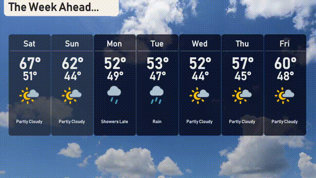
For the 7-day forecast in Chicago:
Saturday: Partly cloudy skies with a high of 67 degrees and a low of 51.
Sunday: Expect some clouds, cooling slightly to a high of 62 degrees and a low of 44.
Monday: Showers arrive late in the day with temperatures peaking at 52 degrees and a low of 49.
Tuesday: Rain continues through the day with a high of 53 degrees and a low of 47.
Wednesday: Look forward to drier conditions, partly cloudy with a high of 52 degrees and a low of 44.
Thursday: Partly cloudy again, warmer with the temperature reaching 57 degrees, dipping to 45 overnight.
Friday: Closing the week with partly cloudy skies and a high of 60 degrees, a low of 48.