From Calm Skies to Stormy Nights: Chicago and the Midwest’s Weather Whirl
By
Amy Freeze
Dive into this comprehensive look at the Midwest's weather patterns with Meteorologist Amy Freeze. From serene evenings in Chicago to storm alerts in Indianapolis, know what the week holds for your area!
Catch a glimpse of what this week’s Midwest weather holds. Amy Freeze breaks down serene skies, sudden showers, and chilly forecasts!
Hello Midwest dwellers! Meteorologist Amy Freeze here with a glance at the ever-changing tapestry of your local weather. As we move through the week, expect various shifts from clear to cloudy skies, punctuated by sudden rainfall and significant temperature drops. Discover how these patterns will affect Chicago and surrounding cities, and learn what you can do to stay prepared. For an in-depth daily breakdown, remember to visit us online!
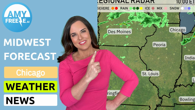
The radar image for the Midwest region presents a varied tapestry of weather conditions. Starting from the south and moving northward, substantial rainfall is impacting Bowling Green, surging northward toward Louisville. This rain band is gradually advancing toward Indianapolis, suggesting an umbrella might be an excellent companion for the day, primarily as the system builds strength toward Fort Wayne.
Farther northeast, Columbus is experiencing scattered showers, and this precipitation is expected to drift toward Cleveland, keeping the region wet. Detroit to Saginaw seems to catch a break with drier conditions persisting for now. St. Louis and Springfield are under dry conditions.
All eyes on Indianapolis as this system approaches, with expectations of increasing cloudiness ahead of the rain. Kansas City remains comfortably out of the rain’s reach today, enjoying more tranquil weather. Regions farther south, like Charleston, are under heavier rain bands, causing the area’s moisture content to spike.
For this evening in Chicago, temperatures will cool down gradually, beginning at 38 degrees at 8 PM, dropping to 37 degrees by 10 PM, and reaching 36 degrees by midnight. Expect clear skies initially turning mostly clear as the evening progresses. Winds will blow gently from the northeast, starting at 8 miles per hour and decreasing to 5 miles per hour closer to midnight.
Tonight, the Midwest is bracing for a chilly night as colder air settles in. In Chicago, expect a low of 42 degrees, while Fort Wayne will dip to 38. Indianapolis is looking at a low of 48, but farther to the north, Saginaw will see a much colder 29 degrees. Temperatures are 36 in both Detroit and Cleveland. St. Louis will stay warmer at 55 degrees.
High temperatures for tomorrow in the Midwest are showing a notable range, with some areas experiencing above-average warmth.
– **Kansas City** will reach a comfortable **65 degrees**.
– Over in **Springfield**, expect slightly warmer conditions, peaking at **67 degrees**.
– **St. Louis** warms up to **61 degrees**, while **Peoria** may see a high of **53 degrees**.
– **Indianapolis** will hover around **56 degrees**, which is near seasonal averages.
– **Chicago** is on the cooler side at about **45 degrees**.
– The temperature in **Louisville** is looking mild with a high of **62 degrees**.
– **Bowling Green** stands out with the highest forecasted temperature in the area at **66 degrees**.
– Meanwhile, **Fort Wayne** will remain cooler at **49 degrees**.
Overall, a mix of mild and cool temperatures is influenced by an oscillating weather pattern that’s keeping warmer air in place for much of the region.
In the Midwest, a cold front sweeping through will bring active weather from today into tomorrow. Expect showers and scattered thunderstorms over to Indianapolis, with the possibility of heavy downpours leading to localized flooding. Cool air filters in behind the front, dropping temperatures about 5 to 10 degrees across the region.
On the futurecast, the risk of severe weather is elevated for areas closer to Chicago and Detroit, so keep a lookout for storm warnings. As the front progresses farther east, Cleveland and Columbus could see strong storms that may disrupt travel.
For Chicago today, the UV index stands at 5, indicating a moderate level of sun exposure with an expected burn time of approximately 27 minutes in direct sunlight. Tomorrow’s forecast remains the same, with a UV index of 5.
Here’s the 7-day forecast for Chicago:
Monday: Partly cloudy with a high of 46 degrees and a low of 32.
Tuesday: Expect thundershowers late, with temperatures reaching a high of 46 and a low of 43.
Wednesday: Showers early in the day, with a high of 46 degrees and a low of 43.
Thursday: Mostly cloudy skies with a warmer high of 56 degrees and a low of 41.
Friday: Cloudy with showers throughout the day, reaching a high of 49 degrees and a low of 42.
Saturday: More showers expected with a high of 48 degrees and a low of 38.
Sunday: Partly cloudy conditions, with a high of 47 degrees and a low of 30.
Stay safe!